Washington hiking trails - Smooth Ridge Trail, Blue Mountains, Columbia County

   
  There are backcountry hiking trails all over Washington, and Smooth Ridge Trail is one of them, and it's in Columbia County. Smooth Ridge Trail is positioned a pretty long journey from La Grande, but it is an amusing place to trek. There are numerous backcountry hiking trails in Washington, and each one has something unique to offer. Smooth Ridge Trail has only one trailhead, so in and out is the way to backcountry walk it normally. Finally, backpacking time is here again, and Smooth Ridge Trail in Columbia County, Washington is just what you need.
    This walk should take you about 5.5 days, so make sure you've got all your overnight gear packed. With its 36.8 miles of walking distance; it's considered a longer backcountry trek. This neighborhood does get very dry sometimes, so do check for current fire restrictions before
you go if you plan to bring a stove or make a camp fire. Keep in mind that this is a long great outdoors hiking trail, so do pack enough food to last the whole trip. In Washington you never run out of outdoors fun. This wilderness hiking trail is many miles long with an average amount of climbing distance which makes this a very tough wilderness trail for advanced backcountry walkers looking for an outstanding challenge. Backpacking in Washington is so much fun. Backcountry hiking here in the Blue Mountains is a very fine way to see these hills. This  
is just one of a large number of wilderness trails in this region. Please follow all local rules about fires and camping. Smooth Ridge Trail goes through some very different elevations, and that means that some parts of the great outdoors trail could be very different from other parts of it. Around Smooth Ridge Trail you don’t get a lot of rain; January is the month that gets the most rain, and the driest month is July. Smooth Ridge Trail has a total elevation difference of 5,156 feet which is a higher than average number. Throughout the summer months here at Smooth Ridge Trail, high temperatures frequently reach the 80's. Once the sun is down it sinks down to the 50's. Through the wintertime this place gets highs in the 40's; nighttime lows at Smooth Ridge Trail through the wintertime ordinarily sink into the 20's.

Briefly about the general area:
Stay the night at Teepee Campground; unsurprisingly Trout Creek flows through this vicinity. These mountains rock, just look at all the exciting stuff to do in the Blue Mountains. Smooth Ridge Trail is a good place to visit for more than one day, Tepee Campground is a good place to camp nearby, and close by you stumble on pleasant locations like Cross Canyon.
You completely must adore the Blue Mountains. You have to stop at Getaway Point when you're here at Smooth Ridge Trail, and whitewater paddling is not for everybody but if it's for you then, we recommend Grande Ronde River. So many amusing things to do here at Smooth Ridge Trail, too pleasant to be true. Places like Ant Flat are nice to stop by, and get your heart beating on the nice whitewater of Grande Ronde River.
Ant Flat is a great place, and Bobcat Spring is an inspiring site to explore during your stay. A quick visit to Third Creek in the vicinity of Smooth Ridge Trail is a magnificent idea, and a short spree to Patterson Spring is always worthwhile.

Location of Trailhead: Latitude 45.9656, Longitude -117.5955
- - Directions and Road Map

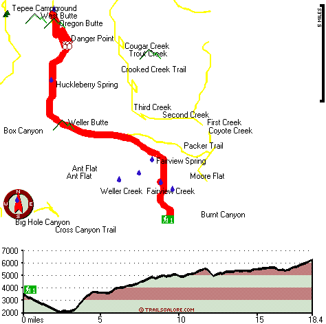
Total in and out hiking length = 36.8 miles

Total climbing distance = 15.5 miles

Difficulty : Difficult

Casual Hiking Pace: 5.5 days

Fast Hiking Pace: 3.5 days

Total elevation difference: 5156 feet


Best Western Rama Inn & Suites, Enterprise
38 miles away
This full-service Enterprise, Oregon hotel is minutes away from local attractions and is an ideal weekend getaway from busy everyday life. Enjoy a peaceful and relaxing getaway to Northwestern Orego...
  
Best Western Rivertree Inn, Clarkston
44 miles away
Stay at this Clarkston hotel and experience an exceptional staff and comfortable accommodations near Washington State's key area attractions and business locations. Located at the Gateway to Hell's C...
User input for Smooth Ridge Trail, Blue Mountains, Columbia County, Washington:

Submit Input:
Your Name:
Write or Paste Input here:

Upload picture:      Review Guidelines


Outdoors Recreation Near La Grande, Oregon
Very comprehensive list of a variety of outdoors recreation in the vicinity of La Grande, Oregon, the metro area neareast to Smooth Ridge Trail. Find info on campgrounds, hiking trails, ski resorts, lakes, beaches, parks, whitewater and more.

Current weather conditions at Smooth Ridge Trail, Blue Mountains, Columbia County, Washington
WXPort

Local climate location: POMEROY 21 miles away

Best Western Wheatland Inn, Colfax
45 miles away
Stay at this pet-friendly Colfax, Washington hotel situated in the heart of the Palouse River near Washington State University, the Colfax Trail and the University of Idaho. Located near Southeastern...

Quality Inn & Suites Conference Center, Clarkston
45 miles away
The Quality Inn and Suites features a restaurant on premise with free full hot breakfast each morning for each registered adult. All rooms are newly renovated and come with a microwave, refrigerator, ...

More Hotels and Campgrounds Near Smooth Ridge Trail, Blue Mountains, Columbia County, Washington

OTHER_INFO
  Blue Mountains Campgrounds
Complete list of all the campgrounds in the Blue Mountains.

Blue Mountains Outdoors Info
Complete outdoors info for the Blue Mountains.

Washington Hiking Trails
Complete list of all hiking trails in Washington

Books about hiking trails in Washington
List of books available on Amazon.com about hiking trails in Washington.

Washington Outdoors Index
This is a very comprehensive index of outdoors activities in the great state of Washington.


TOPO
High quality water resistant topo map of Smooth Ridge Trail, Blue Mountains, Columbia County, Washington.

OUTDOORS_GUIDE
These outdoors activities are available near Smooth Ridge Trail.
 Trails Near Smooth Ridge Trail:
Crooked Creek Trail, Garfield County County , 2 miles away, 21.4 hiking miles, 4731 feet elevation difference
Packer Trail, Garfield County County , 4 miles away,  14.2 hiking miles, 2776 feet elevation difference
Mount Misery Trail, Columbia County County , 5 miles away,  22.8 hiking miles, 969 feet elevation difference
Cross Canyon Trail, Wallowa County County , 5 miles away,  9 hiking miles, 2827 feet elevation difference
Grizzly Bear Trail, Columbia County County , 6 miles away,  25.2 hiking miles, 3837 feet elevation difference
Melton Creek Trail, Garfield County County , 6 miles away,  16.4 hiking miles, 4283 feet elevation difference
East Butte Creek Trail, Columbia County County , 7 miles away,  27.4 hiking miles, 3023 feet elevation difference
 Camp Grounds Near Smooth Ridge Trail:
Tepee Campground, Columbia County, 6 miles away
Teepee Campground, Columbia County, 6 miles away
Panjab Campground, Columbia County, 9 miles away
Spruce Spring Campground, Garfield County, 9 miles away
Tucannon Campground, Columbia County, 10 miles away
 Whitewater Near Smooth Ridge Trail:
Grande Ronde River, Wallowa County County , 13 miles away, Class II-III - 46 miles long (Wallowa River to Grande Ronde River)
Grande Ronde River, Asotin County County , 20 miles away, Class II-III - 19.5 miles long (Troy to Boggan's Oasis)
Grande Ronde River, Union County County , 26 miles away, Class II-IV - 13 miles long (Elgin to Palmer Junction)
Grande Ronde River, Asotin County County , 36 miles away, Class II-IV - 27 miles long (Boggan's Oasis to Snake River)
Grande Ronde River, Union County County , 37 miles away, Class I - 32 miles long (Riverside City Park to Elgin)
 Hotels Near Smooth Ridge Trail:
Best Western Rama Inn & Suites, Enterprise , 38 miles away
Best Western Rivertree Inn, Clarkston , 44 miles away
Best Western Wheatland Inn, Colfax , 45 miles away
Quality Inn & Suites Conference Center, Clarkston , 45 miles away
Best Western Rama Inn & Suites, La Grande , 45 miles away

Outdoors related information copyright © Stratus-Pikpuk, Inc. - Detailed hotel information copyright © Interactive Hotel Solutions