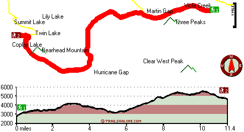
| |
|
| | There are numerous backcountry trails in Washington, and each one has something unique to offer. You'll must go far from Seattle-Tacoma-Bellevue to get to Carbon Trail, but backpacking it is always cool. As long as you like the great outdoors you will like Washington. Different parts of this backcountry trail are at very different elevations, and that means that some parts of the backcountry trail could be very different from other parts of it. Backcountry trekking here in Washington is something that is always fun to do. A large amount of rain falls |
|
at Carbon Trail; most of the rain falls through November, and July meanwhile is the driest month. These backcountry hiking trails here in the Northern Cascade Range are a very fine way to see these highlands. There are so many backpacking trails in this neighborhood. Please follow
| | all local rules about fires and camping. At Carbon Trail during the summer highs are in the 70's while overnight lows are regularly in the 50's. Throughout the winter this place gets highs in the 40's with temperatures at Carbon Trail dipping down into the 30's through winter nights. With its 22.8 miles of walking distance; it's a long backcountry trail. This backcountry hiking trail is many miles long with an average amount of climbing distance which makes this backpacking trail tremendous for hard core backpackers looking for adventure. Of course, this is | |
|
an overnight walk, 3.5 days normally, so it's a wonderful thing if your backpack is big enough to do the job. The total elevation difference for this backpacking trail is 3,299 feet which is a higher than average number. Now this great outdoors hiking trail is pretty long, so don't
forget to pack enough supplies. Wilderness hiking trails for backcountry backpacking, and backpacking can be found all over Washington; Carbon Trail in Pierce County is one of them. Spending too much time indoors got you down? No problem, Carbon Trail in Pierce County, Washington
is such a wonderful site. Carbon Trail is a two ended backpacking trail with two trailheads, so if you can get a ride from someone, you can backcountry walk it just one way.
Briefly about the general area: You simply must fancy the Northern Cascade Range. Getting to
Test Creek from Carbon Trail is simple; obviously, A spree to Hurricane Gap is always fun. Don't leave Carbon Trail without first paying a visit to Alice Falls, and Scarface is very near and is a tremendous site to have a look at. This river is so good. There are some nice
whitewater spots on Clearwater River - White River Tributary, and do set aside some time for Mosquito Flat if you're here at Carbon Trail. The beauty of mother nature reveals herself at Cress Falls; whitewater paddling is not for everybody but if it's for you then, we recommend
White River. Man, is there loads of exciting stuff to do in the Northern Cascade Range. You'll need more than a day to explore everything Carbon Trail has to offer, you can camp at Ipsut Creek Campground; why not take a little trip to Lily Creek if you're here. Don't you try
to stop me, cause I'm havin' a great time here at Carbon Trail. There's so much to do here at Carbon Trail that you need to camp here for a while, White River Campground is a brilliant place for that, and you should beyond doubt dedicate some time to Bee Flat since you're here at Carbon Trail. At this river you will never have a bad time. A journey to Mount Rainier National Park is worthwhile.
|
|
Location of Trailhead 1: Latitude 47.0471, Longitude -121.7127 - - Directions and Road Map
Location of Trailhead 2: Latitude 47.0322, Longitude -121.8272 - - Directions and Road Map

Trailhead 1 to Trailhead 2: Total hiking length = 11.4 miles Total climbing distance = 5.9 miles Difficulty : Difficult Casual Hiking Pace:
2 days
Fast Hiking Pace:
6 hours
Trailhead 2 to Trailhead 1: Total hiking length = 11.4 miles Total climbing distance = 4.5 miles Difficulty : Difficult Casual Hiking Pace:
1.5 days
Fast Hiking Pace:
5.5 hours
| | Trailhead 1 back to Trailhead 1: Total hiking length = 22.8 miles Total climbing distance = 10.4 miles Difficulty : Difficult Casual Hiking Pace:
3.5 days
Fast Hiking Pace:
2.5 days
Trailhead 2 back to Trailhead 2: Total hiking length = 22.8 miles Total climbing distance = 10.4 miles Difficulty : Difficult Casual Hiking Pace:
3.5 days
Fast Hiking Pace:
2.5 days
|
Total elevation difference: 3299 feet

Kings Value Inn - Enumclaw, Wa, Enumclaw
|
16 miles away
Kings Valu Inn **Free Wireless Internet - Outdoor Seasonal Pool - In-Room Coffee - Quality Rooms** Kings Valu Inn is the complete home away from home for your traveling convenience. Stay for a day, a ...
|
| |
Mt. View Inn, Buckley
|
20 miles away
Located 6 miles from White River Amphitheater and with easy access to Mt. Rainier National Park, the AAA-approved 2 diamond Mt. View Inn Buckley, a Magnuson Hotels affiliate, is located on State Highw...
|
|
User input for Carbon Trail, Northern Cascade Range, Pierce County, Washington:

Outdoors Recreation Near Seattle-Tacoma-Bellevue, Washington Very comprehensive list of a variety of outdoors recreation in the vicinity of Seattle-Tacoma-Bellevue, Washington, the metro area neareast to Carbon Trail. Find info on campgrounds, hiking trails, ski resorts, lakes, beaches, parks, whitewater and more.
More Hotels and Campgrounds Near Carbon Trail, Northern Cascade Range, Pierce County, Washington
| |
| |
 |
|
| These outdoors activities are available near Carbon Trail. |
| | Trails Near Carbon Trail:
 |
Clearwater Trail, Pierce County
County
, 4 miles away, 10.6 hiking miles, 2788 feet elevation difference |
 |
Flip-O-Way Trail, Pierce County
County
, 4 miles away, 2.7 hiking miles, 2399 feet elevation difference |
 |
Summit Lake Trail, Pierce County
County
, 5 miles away, 5.1 hiking miles, 1322 feet elevation difference |
 |
Northern Loop Trail, Pierce County
County
, 5 miles away, 32.2 hiking miles, 4766 feet elevation difference |
 |
Ipsut Creek Trail, Pierce County
County
, 7 miles away, 4.8 hiking miles, 3790 feet elevation difference |
 |
Paul Peak Trail, Pierce County
County
, 10 miles away, 3 hiking miles, 1081 feet elevation difference |
 |
Moraine Trail, Pierce County
County
, 11 miles away, 2.4 hiking miles, 452 feet elevation difference |
|
| | Whitewater Near Carbon Trail:
 |
Clearwater River - White River Tributary, Pierce County
County
, 6 miles away, Class III - 4 miles long (Bridge to confluence with White River) |
 |
White River, Pierce County
County
, 6 miles away, Class III - 13.5 miles long (West Fork to Bridge Camp) |
 |
Greenwater River, Pierce/King County
County
, 14 miles away, Class II(IV) - 7.2 miles long (FR 7030 Bridge to Highway 410) |
 |
White River, Pierce County
County
, 14 miles away, Class III - 10 miles long (Silver Springs Campground to West Fork White) |
 |
South Praire Creek, Pierce County
County
, 15 miles away, Class V - 6.6 miles long (East Fork to Spiketon Road) |
|
| | Hotels Near Carbon Trail:
 |
King's Valu Inn, Enumclaw
, 16 miles away |
 |
Kings Value Inn - Enumclaw, Wa, Enumclaw
, 16 miles away |
 |
Park Center Hotel, Enumclaw
, 17 miles away |
 |
Lee Hotel, Enumclaw
, 17 miles away |
 |
Alexander's Country Inn, Ashford
, 18 miles away |
|
|
|
 |
|