| |
|
| | Dinner Ridge Way is located a relatively long journey from Eugene-Springfield, but it is a great sanctuary from the urban center. Backpacking here in Oregon never gets boring. Ok, you've been cooped up too long, time to get out in the outdoors a bit, and Dinner Ridge Way in Lane County, Oregon is a great spot for getting out. At parts of the year this vicinity sees very little rain, so don’t forget to check for any current fire restrictions before you go. The length of this backpacking trail is on the longer side having an average number of uphill miles |
|
which makes it a fine hiking and backpacking trail for experienced trekkers in delightful shape. Please follow all local rules about fires and camping. Different parts of Dinner Ridge Way are at very different elevations which of course means you need to be prepared for different
| | conditions on different parts of the great outdoors trail. In Oregon you never run out of outdoors fun. All through the long summer days, highs frequently are in the 80's at Dinner Ridge Way with night lows in the 50's. Throughout the wintertime this place gets highs in the 40's; after the sun is down during the wintertime temperatures at Dinner Ridge Way drop into the 30's. There are two trailheads to chose from, one in each end, so hiking it one way is an option if you can arrange for a ride back. This backcountry hike should take you about 2.5 days, | |
|
so make sure you've got all your overnight gear packed. This is a region covered with lots of hiking and backpacking trails. Being 15.4 miles long; it's considered a longer hike. The striking backpacking trails of the Central Cascade Range are a really wonderful way to spend quality
time in the great outdoors. There are many perfect hiking trails in Oregon; Dinner Ridge Way in Lane County is one of them. This hiking and backpacking trail has a total elevation difference of 4,056 feet which is higher than average. Keep in mind that this is a long hiking and
backpacking trail, so don't forget to pack enough supplies. All the water falling down from the sky makes Dinner Ridge Way a wet place; the wettest month of the year is ordinarily November, that's the one that rains the most while July is the month with the least amount of precipitation.
Each one of the many hiking trails of Oregon is different from the others.
Briefly about the general area: All the outdoors exciting stuff in the Central Cascade Range will keep you coming back persistently. Sand Prairie is a perfect spot; if you came for an overnight
stay Errin Campground is a wonderful site to camp. Yeah, come up here to the Central Cascade Range for a magnificent time. Spot Creek is one of the streams close by that might be worth a visit, and Larison Cove is nearby and always splendid to go to. There's some flowing water
close by, Gray Creek is a stream you can explore while you're here, and Oakridge Mobile Home Park is a good local campground. Yep, outdoors cool stuff to do are really plentiful here at Dinner Ridge Way. Put some time aside to spend at Moonfalls since you're here at Dinner Ridge
Way, and get your heart pumping on the magnificent whitewater of Brice Creek. Holland Meadows is a brilliant location to check out, and there's whitewater on Willamette River - Middle Fork for all you adrenaline rush seekers.
|
|
Location of Trailhead 1: Latitude 43.6689, Longitude -122.4353 - - Directions and Road Map
Location of Trailhead 2: Latitude 43.6675, Longitude -122.5733 - - Directions and Road Map

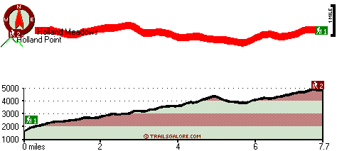
Trailhead 1 to Trailhead 2: Total hiking length = 7.7 miles Total climbing distance = 5.3 miles Difficulty : Difficult Casual Hiking Pace:
8 hours
Fast Hiking Pace:
4.5 hours
Trailhead 2 to Trailhead 1: Total hiking length = 7.7 miles Total climbing distance = 1.4 miles Difficulty : Difficult Casual Hiking Pace:
5.5 hours
Fast Hiking Pace:
3 hours
| | Trailhead 1 back to Trailhead 1: Total hiking length = 15.4 miles Total climbing distance = 6.7 miles Difficulty : Difficult Casual Hiking Pace:
2.5 days
Fast Hiking Pace:
9 hours
Trailhead 2 back to Trailhead 2: Total hiking length = 15.4 miles Total climbing distance = 6.7 miles Difficulty : Difficult Casual Hiking Pace:
2.5 days
Fast Hiking Pace:
9 hours
|
Total elevation difference: 4056 feet

Best Western Oakridge Inn, Oakridge
|
4 miles away
This Oakridge, Oregon hotel offers a complimentary continental breakfast each morning and convenient access to a variety of outdoor activities. Discover the Best Western Oakridge Inn, nestled agains...
|
| |
Super 8 Creswell, Creswell
|
37 miles away
Conveniently located on I-5 at Exit, 182, our Super 8 is AAA approved. We have a friendly staff and are also Pet Friendly. We offer a SuperStart Breakfast, Free High Speed Wirelless Internet, an Out...
|
|
User input for Dinner Ridge Way, Central Cascade Range, Lane County, Oregon:

Outdoors Recreation Near Eugene-Springfield, Oregon Very comprehensive list of a variety of outdoors recreation in the vicinity of Eugene-Springfield, Oregon, the metro area neareast to Dinner Ridge Way. Find info on campgrounds, hiking trails, ski resorts, lakes, beaches, parks, whitewater and more.
More Hotels and Campgrounds Near Dinner Ridge Way, Central Cascade Range, Lane County, Oregon
| |
| |
 |
|
| These outdoors activities are available near Dinner Ridge Way. |
| | Trails Near Dinner Ridge Way:
 |
Packard Creek Trail, Lane County
County
, 2 miles away, 4.9 hiking miles, 2844 feet elevation difference |
 |
Larison Creek Trail, Lane County
County
, 2 miles away, 1.6 hiking miles, 191 feet elevation difference |
 |
Rocky Point Way, Lane County
County
, 3 miles away, 4.4 hiking miles, 2915 feet elevation difference |
 |
Grass Mountain Trail, Lane County
County
, 4 miles away, 0.6 hiking miles, 341 feet elevation difference |
 |
Holland Meadows Trail, Lane County
County
, 4 miles away, 1.4 hiking miles, 603 feet elevation difference |
 |
Johnson Meadows Trail, Lane County
County
, 5 miles away, 2.3 hiking miles, 1607 feet elevation difference |
 |
Willamette Divide Trail, Lane County
County
, 6 miles away, 3.8 hiking miles, 884 feet elevation difference |
|
| | Whitewater Near Dinner Ridge Way:
 |
Willamette River - Middle Fork, Lane County
County
, 5 miles away, Class II - 12.5 miles long (Hills Creek Dam to Lookout Point Reservoir) |
 |
Brice Creek, Lane County
County
, 8 miles away, Class IV-V - 4.5 miles long (Parker Falls to Champion Creek) |
 |
Salmon Creek, Lane County
County
, 9 miles away, Class II-V - 12 miles long (Top of Upper Salmon Creek Gorge to Oakridge) |
 |
Champion Creek, Lane County
County
, 10 miles away, Class IV-V - 1.1 miles long (Gorge 1 mile above Brice Creek to Brice Creek) |
 |
Willamette River - North Fork of Middle Fork, Lane County
County
, 11 miles away, Class IV-V - 13.5 miles long (to Westfir) |
|
| | Hotels Near Dinner Ridge Way:
 |
Best Western Oakridge Inn, Oakridge
, 4 miles away |
 |
Super 8 Creswell, Creswell
, 37 miles away |
 |
Moonstone Village Green Resort, Cottage Grove
, 38 miles away |
 |
Comfort Inn Cottage Grove, Cottage Grove
, 38 miles away |
 |
Holiday Inn Express Cottage Grove, Or, Cottage Grove
, 38 miles away |
|
|
|
 |
|