| |
|
| | Hey, time for a trek don’t you think? if you happen to be in Gila County of Arizona, Hells Gate Trail is an outstanding local wilderness hiking trail for doing a bit of leg stretching. As long as you like the outdoors you will like Arizona. Every single Arizona great outdoors hiking trail is different from the others. Some parts of this wilderness trail are much higher up than other parts of the wilderness trail which of course means you need to be prepared for different conditions on different parts of the wilderness trail. The length of this hiking |
|
trail is on the longer side with an average amount of climbing distance which makes this wilderness trail good for hard core backpackers looking for adventure. This is a region covered with lots of wilderness trails. Hells Gate Trail is 19 miles long; it's a long wilderness trail.
| | Trekking here in the Mogollon Rim Mountains is an excellent way to explore these mountains. Of course, this is an overnight backcountry hike, 3 days normally, so better have big backpack to fit all the stuff you need. Keep in mind that this is a long wilderness hiking trail, so do pack enough food to last the whole trip. The total elevation difference for this great outdoors hiking trail is 2,084 feet which is about average. A typical amount of precipitation falls here at Hells Gate Trail; during August this region sees the most rain; June meanwhile is | |
|
the driest month. Hells Gate Trail is a long tour away from Payson, but it sure is a an outstanding wilderness hiking trail. Please follow all local rules about fires and camping. Hells Gate Trail is a two ended great outdoors hiking trail with two trailheads which means you have
the option of trekking it one way if you have someone to pick you up at the other end. Going for a walk here in Arizona never gets boring. Backpacking and hiking trails are pleasant and plentiful in Arizona; one of those is Hells Gate Trail in Gila County. The warmest time of the
year at Hells Gate Trail arrives with high temperatures in the 90's. Summer nighttime lows fall down to the 50's. All through the winter the highs are typically in the 50's; after the sun is down all through the winter temperatures at Hells Gate Trail fall into the 20's. Sometimes
this wilderness hiking trail gets really dry, so do check for current fire restrictions before you go if you plan to bring a stove or make a camp fire.
Briefly about the general area: Whohoo, so many amusing things in one place! The Mogollon Rim Mountains is unbeatable!
The beauty of mother nature reveals herself at Mud Spring, and if you came for an overnight stay Star Vale is a brilliant location to camp. You just can't picture the amount of outdoors cool things the Mogollon Rim Mountains has to offer. Bear Flat is right here at Hells Gate Trail.
Whitewater paddling is not for everyone but if it's for you then we recommend Tonto Creek, and Bear Flat Campground is a great local campground. Haigler Creek is a tremendous local stream; get your heart pumping on the perfect whitewater of East Verde River. Wildcat Spring is an
inspiring place to take a look at while you're here, and swing by Horton Creek it's a tremendous place to take a look at. That right there is loads already, but it keeps on going; Hells Gate Trail has it all. A pleasant place like Derrick Pocket here at Hells Gate Trail is too fine to miss, and since you're here, you might as well stop at Little Green Valley.
|
|
Location of Trailhead 1: Latitude 34.2804, Longitude -111.1337 - - Directions and Road Map
Location of Trailhead 2: Latitude 34.1822, Longitude -111.0972 - - Directions and Road Map

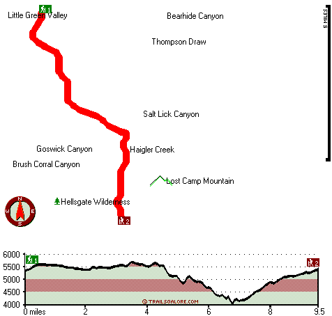
Trailhead 1 to Trailhead 2: Total hiking length = 9.5 miles Total climbing distance = 4.5 miles Difficulty : Difficult Casual Hiking Pace:
8.5 hours
Fast Hiking Pace:
5 hours
Trailhead 2 to Trailhead 1: Total hiking length = 9.5 miles Total climbing distance = 4.1 miles Difficulty : Difficult Casual Hiking Pace:
8.5 hours
Fast Hiking Pace:
4.5 hours
| | Trailhead 1 back to Trailhead 1: Total hiking length = 19 miles Total climbing distance = 8.6 miles Difficulty : Difficult Casual Hiking Pace:
3 days
Fast Hiking Pace:
2 days
Trailhead 2 back to Trailhead 2: Total hiking length = 19 miles Total climbing distance = 8.6 miles Difficulty : Difficult Casual Hiking Pace:
3 days
Fast Hiking Pace:
2 days
|
Total elevation difference: 2084 feet

Kohls Ranch Lodge, Payson
|
8 miles away
Located on the Banks of Tonto Creek in the largest Ponderosa Pine Forest in the world, Kohl*s Ranch Lodge is historically famous for its western hospitality. The Lodge is near the Mogollon Rim in the ...
|
| |
Super 8 Motel, Payson
|
12 miles away
The Super 8 is centrally located in Payson to enjoy local attractions like Christopher Creek. Free High Speed Internet Access Free Local Calls Outdoor Whirlpool/Hot Tub Outdoor Pool and Heated Spa Ext...
|
|
User input for Hells Gate Trail, Mogollon Rim Mountains, Gila County, Arizona:

Outdoors Recreation Near Payson, Arizona Very comprehensive list of a variety of outdoors recreation in the vicinity of Payson, Arizona, the metro area neareast to Hells Gate Trail. Find info on campgrounds, hiking trails, ski resorts, lakes, beaches, parks, whitewater and more.
|
Current weather conditions at Hells Gate Trail, Mogollon Rim Mountains, Gila County, Arizona

Local climate location: PAYSON 8 miles away

           
| |
Best Western Payson Inn, Payson
|
13 miles away
**Hotel Pool and Hot Tub will be closed for the Winter season beginning November 1, 2008 to May 1, 2009** This full-service Payson, Arizona hotel offers a variety of amenities, a deluxe continental b...
|
Holiday Inn Express Payson, Az, Payson
|
13 miles away
Payson is nestled among the Ponderosa pines and clean air of the Mogollon Rim. The Tonto Natural Bridge, camping, hiking, fishing, hunting and boating areas are a short drive away. The Holiday Inn Exp...
|
|
More Hotels and Campgrounds Near Hells Gate Trail, Mogollon Rim Mountains, Gila County, Arizona
| |
| |
 |
|
| These outdoors activities are available near Hells Gate Trail. |
| | Trails Near Hells Gate Trail:
 |
Highline Trail, Gila
County
, 6 miles away, 6.9 hiking miles, 2002 feet elevation difference |
 |
Horton Creek Trail, Gila
County
, 6 miles away, 8.8 hiking miles, 722 feet elevation difference |
 |
Bear Flat Pleasant Valley Trail, Gila
County
, 7 miles away, 7.7 hiking miles, 1293 feet elevation difference |
 |
Myrtle Trail, Gila
County
, 8 miles away, 2.7 hiking miles, 1565 feet elevation difference |
 |
Old Mail Trail, Gila
County
, 13 miles away, 10.2 hiking miles, 2203 feet elevation difference |
|
| | Whitewater Near Hells Gate Trail:
 |
Tonto Creek, Gila County
County
, 20 miles away, Class IV(V) - 2 miles long (Box) |
 |
East Verde River, Gila County
County
, 26 miles away, Class V+ - 34 miles long (US Route 87 to Verde River confluence) |
 |
Chevelon Creek, Coconino/ Navajo County
County
, 36 miles away, Class -blank- - 75 miles long (Woods Canyon Lake to Little Colorado River) |
 |
Verde River, Yavapai County
County
, 39 miles away, Class I-III - 25 miles long (Childs to Horseshoe Reservoir) |
|
| | National Parks Near Hells Gate Trail:
 |
Tonto National Monument, Roosevelt - AZ
, 38 miles away |
 |
Montezuma Castle National Monument, Camp Verde - AZ
, 51 miles away |
 |
Tuzigoot National Monument, Clarkdale - AZ
, 51 miles away |
|
| | Hotels Near Hells Gate Trail:
 |
Kohls Ranch Lodge, Payson
, 8 miles away |
 |
Super 8 Motel, Payson
, 12 miles away |
 |
Best Western Payson Inn, Payson
, 13 miles away |
 |
Holiday Inn Express Payson, Az, Payson
, 13 miles away |
 |
Pine Victorian Inn, Payson
, 13 miles away |
|
|
|
 |
|