Arizona hiking trails - Boulder Creek Trail, Mogollon Rim Mountains, Maricopa County

   
  Hitting the backcountry hiking trails is always an amusing thing to do, and Boulder Creek Trail in Maricopa County, Arizona is such a perfect spot. When you're here in Arizona backcountry backpacking along one of its hiking and backpacking trails is a brilliant way to spend some time. Arizona has lots of outdoors things to do. With its 9 miles of walking distance it's an average length wilderness trail. This is an area covered with lots of great outdoors trails. Each one of the many hiking and backpacking trails of Arizona has something unique to offer.
    Arizona has plenty of pleasant hiking and backpacking trails, and one of these is Boulder Creek Trail in Maricopa County. Don’t forget to check for any current restrictions or closures before you go. This wilderness trail goes through some very different elevations, and that means
that some parts of the wilderness trail could be very different from other parts of it. Backcountry backpacking here in the Mogollon Rim Mountains is the best way to enjoy these mountains. Summertime highs at Boulder Creek Trail mostly tend to be in the 100's, and during the night it cools down to the 70's. The wintertime brings highs down to the 60's while Boulder Creek Trail night low temperatures during the wintertime are in the 30's. You should count on this backcountry walk taking about 8 hours, but of course some people walk a bit slower and some a  
bit faster. This is a long wilderness trail, so make sure you bring plenty of supplies. Sometimes this wilderness trail gets really dry, so do check for current fire restrictions before you go if you plan to bring a stove or make a camp fire. This is a two-ended wilderness trail with two trailheads, so if you can get a ride from someone, you can backcountry walk it just one way. This wilderness trail has a total elevation difference of 1,533 feet, and that is about average. This hiking trail is a mid length hiking trail with an average amount of climbing distance which makes this a very tough great outdoors trail for advanced hikers looking for an outstanding challenge. It is very dried out here at Boulder Creek Trail commonly; through December this region sees the most rain, and June is the month with the least moisture. Boulder Creek Trail is not very close to Payson at all, but it is a really tremendous backcountry hiking trail.

Briefly about the general area:
Little Pine Flat is a delightful spot, and Bear Spring is an inspiring place to stop by while here. Don't leave Boulder Creek Trail without first paying a visit to Crabtree Spring, and why not camp at Jakes Corner RV Park since you're here at Boulder Creek Trail.
Yep, outdoors exciting things to do are in fact plentiful here at Boulder Creek Trail. Tonto National Forest is a forest right next door to Boulder Creek Trail that you can go to, and there are some glorious whitewater spots on Tonto Creek. Having a great time in the Mogollon Rim Mountains is simple. Boulder Pass is next to Boulder Creek Trail and is a brilliant spot, and why not a little side trip to Boulder Creek. But wait, there's more amusing things to do in the Mogollon Rim Mountains. Whitewater paddling is not for everyone but if it's for you then we recommend Verde River.
Places like Edwards Park are tremendous to stop by, and if you came for an overnight stay Tonto Creek Trail Adult RV Park is a wonderful spot to camp.

Location of Trailhead 1: Latitude 33.8471, Longitude -111.442
- - Directions and Road Map

Location of Trailhead 2: Latitude 33.8119, Longitude -111.385
- - Directions and Road Map


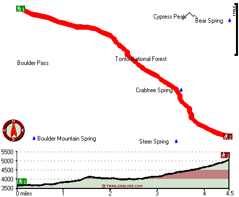
Trailhead 1 to Trailhead 2:
Total hiking length = 4.5 miles
Total climbing distance = 3.2 miles
Difficulty : Difficult
Casual Hiking Pace: 5 hours
Fast Hiking Pace: 2.5 hours

Trailhead 2 to Trailhead 1:
Total hiking length = 4.5 miles
Total climbing distance = .8 miles
Difficulty : Easy
Casual Hiking Pace: 3.5 hours
Fast Hiking Pace: 1.5 hours
    Trailhead 1 back to Trailhead 1:
Total hiking length = 9 miles
Total climbing distance = 4 miles
Difficulty : Difficult
Casual Hiking Pace: 8 hours
Fast Hiking Pace: 5.5 hours

Trailhead 2 back to Trailhead 2:
Total hiking length = 9 miles
Total climbing distance = 4 miles
Difficulty : Difficult
Casual Hiking Pace: 8 hours
Fast Hiking Pace: 5.5 hours

Total elevation difference: 1533 feet


Kohls Ranch Lodge, Payson
23 miles away
Located on the Banks of Tonto Creek in the largest Ponderosa Pine Forest in the world, Kohl*s Ranch Lodge is historically famous for its western hospitality. The Lodge is near the Mogollon Rim in the ...
  
Paysonglo Lodge, Payson
23 miles away
Nestled among the majestic mountains of the Mogollon Rim lies a unique and serene Payson Arizona hotel: Paysonglo Lodge. The perfect spot for a Payson AZ hotel getaway. Here in Payson we offer more...
User input for Boulder Creek Trail, Mogollon Rim Mountains, Maricopa County, Arizona:

Submit Input:
Your Name:
Write or Paste Input here:

Upload picture:      Review Guidelines


Outdoors Recreation Near Payson, Arizona
Very comprehensive list of a variety of outdoors recreation in the vicinity of Payson, Arizona, the metro area neareast to Boulder Creek Trail. Find info on campgrounds, hiking trails, ski resorts, lakes, beaches, parks, whitewater and more.

Current weather conditions at Boulder Creek Trail, Mogollon Rim Mountains, Maricopa County, Arizona
WXPort

Local climate location: BARTLETT DAM 19 miles away

Americas Best Value Inn - Payson, Payson
23 miles away
Welcome to the Americas Best Value Inn. Our hotel is strategically located in Payson, the largest community in Arizona Rim Country. Payson is also one of the fastest growing vacation centers in the ar...

Days Inn and Suites Payson, Payson
24 miles away
Welcome to the Days Inn & Suites of Payson. When you are visiting Payson next, take refuge in this comfortable interior hotel. Experience the difference and we are sure you will make it your home aw...

More Hotels and Campgrounds Near Boulder Creek Trail, Mogollon Rim Mountains, Maricopa County, Arizona

OTHER_INFO
  Mogollon Rim Mountains Campgrounds
Complete list of all the campgrounds in the Mogollon Rim Mountains.

Mogollon Rim Mountains Outdoors Info
Complete outdoors info for the Mogollon Rim Mountains.

Arizona Hiking Trails
Complete list of all hiking trails in Arizona

Books about hiking trails in Arizona
List of books available on Amazon.com about hiking trails in Arizona.

Arizona Outdoors Index
This is a very comprehensive index of outdoors activities in the great state of Arizona.


TOPO
High quality water resistant topo map of Boulder Creek Trail, Mogollon Rim Mountains, Maricopa County, Arizona.

OUTDOORS_GUIDE
These outdoors activities are available near Boulder Creek Trail.
 Trails Near Boulder Creek Trail:
Pipeline Trail, Maricopa County , 4 miles away, 6.5 hiking miles, 2229 feet elevation difference
Pine Mountain Trail, Maricopa County , 4 miles away, 4.3 hiking miles, 1829 feet elevation difference
Denton Trail, Gila County , 6 miles away, 4.9 hiking miles, 3521 feet elevation difference
Soldier Camp Trail, Maricopa County , 10 miles away,  14.4 hiking miles, 2657 feet elevation difference
Four Peaks Trail, Gila County , 10 miles away, 10.1 hiking miles, 3059 feet elevation difference
Baldy Trail, Gila County , 12 miles away,  8 hiking miles, 3403 feet elevation difference
Del Shay Trail, Gila County , 15 miles away,  9.4 hiking miles, 2132 feet elevation difference
 Camp Grounds Near Boulder Creek Trail:
Jakes Corner RV Park, Tonto Basin, 9 miles away
Tonto Creek Trail Adult RV Park, Tonto Basin, 9 miles away
Punkin Center Trailer Corral, Tonto Basin, 9 miles away
Sleepy Hallow RV Park, Tonto Basin, 9 miles away
Apache Lake Campground, Maricopa County, 18 miles away
 Whitewater Near Boulder Creek Trail:
Tonto Creek, Gila County County , 11 miles away, Class IV(V) - 2 miles long (Box)
Verde River, Yavapai / Maricopa County County , 18 miles away, Class I-II - 19 miles long (Horseshoe Reservoir to Bartlett Reservoir)
Verde River, Maricopa County County , 18 miles away, Class I-II - 19 miles long (Bartlett Reservoir to confluence with Salt River)
 National Parks Near Boulder Creek Trail:
Tonto National Monument, Roosevelt - AZ , 31 miles away
Casa Grande Ruins National Monument, Coolidge - AZ , 50 miles away
Hohokam Pima National Monument, Coolidge - AZ , 50 miles away
 Hotels Near Boulder Creek Trail:
Kohls Ranch Lodge, Payson , 23 miles away
Paysonglo Lodge, Payson , 23 miles away
Americas Best Value Inn - Payson, Payson , 23 miles away
Days Inn and Suites Payson, Payson , 24 miles away
Holiday Inn Express PAYSON, Payson , 24 miles away

Outdoors related information copyright © Stratus-Pikpuk, Inc. - Detailed hotel information copyright © Interactive Hotel Solutions