| |
Pacific Crest Trail - section 26 has a total elevation difference of 5,875 feet which is higher than average. Some parts of this backpacking trail are much higher up than other parts of the backpacking trail, and that means that some parts of the backpacking trail could be very different from other parts of it. Pacific Crest Trail - section 26 is quite long, so don't forget to pack enough supplies. Pacific Crest Trail - section 26 is 260.6 miles long; it's considered a longer hike. Of course, this is an overnight trek, 40 days normally, so make sure you've got all your overnight gear packed. Pacific Crest Trail - section 26 is a two ended hiking and backpacking trail with two trailheads, so if you can get a ride from someone, you can backcountry hike it just one way.
|
Trailhead 1 to Trailhead 2:
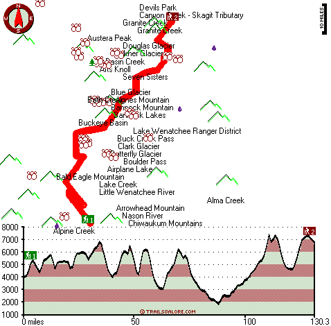
Total hiking length = 130.3 miles
Total climbing distance = 66.6 miles
Difficulty : Difficult
Casual Hiking Pace:
20.5 days
Fast Hiking Pace:
11.5 days
Trailhead 2 to Trailhead 1:
Total hiking length = 130.3 miles
Total climbing distance = 57.8 miles
Difficulty : Difficult
Casual Hiking Pace:
19.5 days
Fast Hiking Pace:
11 days
| | Trailhead 1 back to Trailhead 1:
Total hiking length = 260.6 miles
Total climbing distance = 124.4 miles
Difficulty : Difficult
Casual Hiking Pace:
40 days
Fast Hiking Pace:
26.5 days
Trailhead 2 back to Trailhead 2:
Total hiking length = 260.6 miles
Total climbing distance = 124.4 miles
Difficulty : Difficult
Casual Hiking Pace:
40 days
Fast Hiking Pace:
26.5 days
|
Total elevation difference: 5875 feet
|


