| |
Pacific Crest Trail - section 23 has a total elevation difference of 6,078 feet which is a higher than average number. There are two trailheads to chose from, one in each end, so if you can get a ride from someone, you can hike it just one way. This is a hiking trail that is quite long, so do pack enough food to last the whole trip. Pacific Crest Trail - section 23 is 244.8 miles long; it's longer than many hiking trails. Some parts of Pacific Crest Trail - section 23 are much higher up than other parts of the hiking trail, and that means that some parts of the hiking trail could be very different from other parts of it. Of course, this is an overnight walk, 37.5 days normally, so make sure you've got all your overnight gear packed. This hiking trail sometimes gets very dry, so make sure you check current conditions and fire restrictions with local forest authorities before you head out.
|
Trailhead 1 to Trailhead 2:
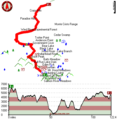
Total hiking length = 122.4 miles
Total climbing distance = 58.8 miles
Difficulty : Difficult
Casual Hiking Pace:
19 days
Fast Hiking Pace:
10.5 days
Trailhead 2 to Trailhead 1:
Total hiking length = 122.4 miles
Total climbing distance = 57 miles
Difficulty : Difficult
Casual Hiking Pace:
18.5 days
Fast Hiking Pace:
10.5 days
| | Trailhead 1 back to Trailhead 1:
Total hiking length = 244.8 miles
Total climbing distance = 115.8 miles
Difficulty : Difficult
Casual Hiking Pace:
37.5 days
Fast Hiking Pace:
25 days
Trailhead 2 back to Trailhead 2:
Total hiking length = 244.8 miles
Total climbing distance = 115.8 miles
Difficulty : Difficult
Casual Hiking Pace:
37.5 days
Fast Hiking Pace:
25 days
|
Total elevation difference: 6078 feet
|


