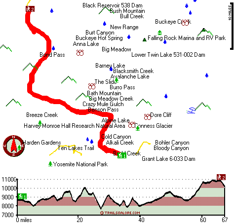
| |
|
| | Could someone tell me ''where'' PCT crosses Hwy 4 Ebbetts Pass? Also, Hwy 108 Sonora Pass and Hwy 120 Tioga Pass? I need to drop food for some hikers. Thank you. Says Carolyn
There are many wonderful hiking and backpacking trails in California, and one of those is Pacific Crest Trail - section 12 in overlapping counties. Going for a trek here in California is so much fun. Backpacking in California is such a magnificent thing to do. Now this trail is pretty long, so do pack enough food to last the whole trip. Pacific Crest Trail - section 12 is a |
|
two ended trail with two trailheads which means you have the option of trekking it one way if you have someone to pick you up at the other end. This trail sometimes gets very dry, so do check for current fire restrictions before you go if you plan to bring a stove or make a camp
| | fire. The total elevation difference for Pacific Crest Trail - section 12 is 4,061 feet which is a higher than average number. Pacific Crest Trail - section 12 is 134 miles long; it's considered a longer backcountry trek. The length of this wilderness hiking trail is on the longer side with an average amount of climbing distance which makes it a wonderful hiking and backpacking trail for experienced backcountry trekkers in perfect shape. When was the last time you got out in the wilderness a bit? Pacific Crest Trail - section 12 in overlapping counties, | |
|
California is a nice place to go. Pacific Crest Trail - section 12 is a very long way away from civilization, and it is a fun place to walk. This is just one of a large number of hiking and backpacking trails in this vicinity. At Pacific Crest Trail - section 12 during the months
of summer highs are in the 80's, and all through the night it cools down to the 30's. Throughout the winter highs are in the 40's with winter lows in the 0's overnight here at Pacific Crest Trail - section 12. These wilderness hiking trails here in the Central Sierra Nevada are
a really great way to spend quality time in the wilderness. Every hiking and backpacking trail in California is worth trekking. It is very dry here at Pacific Crest Trail - section 12 frequently; the wettest month of the year is frequently January, that's the one that snows the
most, and October meanwhile is the driest month. Of course, this is an overnight walk, 20.5 days normally, so better have big backpack to fit all the stuff you need. And keep in mind that there could be temporary safety restrictions in place. This backpacking and hiking trail goes
through some very different elevations, so keep in mind that you may need to dress differently at different elevations.
Briefly about the general area: A visit to Pacific Crest Trail - section 12 wouldn't be complete without taking a look at Horsetail Falls, and a pleasant
trip to Bear Valley is a tremendous way to spend an afternoon. There are some wonderful whitewater spots on West Walker River; Burro Pass is also a great spot to look at. These mountains rock, just check out all the amusing stuff to do in the Central Sierra Nevada. Looking
for some flowing water? Try Blacksmith Creek, and why not camp at Buckeye Campground since you're here at Pacific Crest Trail - section 12. Having a wonderful time at Pacific Crest Trail - section 12 is trouble-free. While you're here at Pacific Crest Trail - section 12 it's a
brilliant idea to explore Big Meadow, and camping is available at Paho Campground. You definitely ought to love the Central Sierra Nevada. If you come at the right time of year, Tuolumne River offers some tremendous whitewater, and hey, Big Meadow Creek is a delightful local stream.
While you're here at Pacific Crest Trail - section 12 you have to pop by Rainbow Point, and Buckeye Hot Spring is an inspiring place to stop by while you're here.
|
|
Location of Trailhead 1: Latitude 37.8769, Longitude -119.3472 - - Directions and Road Map
Location of Trailhead 2: Latitude 38.3282, Longitude -119.63 - - Directions and Road Map

Trailhead 1 to Trailhead 2: Total hiking length = 67 miles Total climbing distance = 36.2 miles Difficulty : Difficult Casual Hiking Pace:
10.5 days
Fast Hiking Pace:
6 days
Trailhead 2 to Trailhead 1: Total hiking length = 67 miles Total climbing distance = 27.2 miles Difficulty : Difficult Casual Hiking Pace:
10 days
Fast Hiking Pace:
5.5 days
| | Trailhead 1 back to Trailhead 1: Total hiking length = 134 miles Total climbing distance = 63.4 miles Difficulty : Difficult Casual Hiking Pace:
20.5 days
Fast Hiking Pace:
13.5 days
Trailhead 2 back to Trailhead 2: Total hiking length = 134 miles Total climbing distance = 63.4 miles Difficulty : Difficult Casual Hiking Pace:
20.5 days
Fast Hiking Pace:
13.5 days
|
Total elevation difference: 4061 feet

The Ahwahnee, Yosemite National Park
|
23 miles away
As a National Historical Landmark and one of the most distinctive resort hotels in North America, The Ahwahnee is well known for its great granite facade, striking beamed ceilings, massive stone heart...
|
| |
Yosemite Gateway Motel, Lee Vining
|
24 miles away
Whether you are traveling to Yosemite National Park in the summer, or are looking for an affordable and comfortable place to stay on your winter vacation, the Yosemite Gateway Motel is the perfect spo...
|
|
User input for Pacific Crest Trail - section 12, Central Sierra Nevada, overlapping counties, California:

Outdoors Recreation Near Phoenix Lake-Cedar Ridge, California Very comprehensive list of a variety of outdoors recreation in the vicinity of Phoenix Lake-Cedar Ridge, California, the metro area neareast to Pacific Crest Trail - section 12. Find info on campgrounds, hiking trails, ski resorts, lakes, beaches, parks, whitewater and more.
|
Current weather conditions at Pacific Crest Trail - section 12, Central Sierra Nevada, overlapping counties, California

Local climate location: BRIDGEPORT 18 miles away

           
| |
dnc -- Wawona Hotel, Yosemite National Park
|
28 miles away
Wawona is one of the oldest mountain resort hotels in California and a National Historic Landmark. Its verdant meadows, rushing streams, and tranquility make this a favorite of those who prefer a rela...
|
Yosemite Lodge at the Falls, Yosemite National Park
|
28 miles away
As the closest property to Yosemite Falls, Yosemite Lodge is an idyllic spot for families, group retreats and visitors seeking to blend the comforts of a hotel while exploring the wilderness. In 1998,...
|
|
More Hotels and Campgrounds Near Pacific Crest Trail - section 12, Central Sierra Nevada, overlapping counties, California
| |
| |
 |
|
| These outdoors activities are available near Pacific Crest Trail - section 12. |
| | Trails Near Pacific Crest Trail - section 12:
 |
Gaylor Lakes Trail, Tuolumne County
counties
, 14 miles away, 4.3 hiking miles, 1445 feet elevation difference |
 |
Ten Lakes Trail, Mariposa County
counties
, 16 miles away, 16.9 hiking miles, 2769 feet elevation difference |
 |
John Muir Trail - section 1, County
counties
, 17 miles away, 18.5 hiking miles, 6931 feet elevation difference |
 |
Early Emigrant and Indian Trail, Mono County
counties
, 19 miles away, 7.6 hiking miles, 2323 feet elevation difference |
 |
Tenaya Lake And Tuolumne Meadows Trail, Mariposa County
counties
, 19 miles away, 10.8 hiking miles, 910 feet elevation difference |
 |
Clouds Rest Trail, Mariposa County
counties
, 20 miles away, 18.8 hiking miles, 6803 feet elevation difference |
 |
Half Dome Trail, Mariposa County
counties
, 21 miles away, 11.6 hiking miles, 5142 feet elevation difference |
|
| | Whitewater Near Pacific Crest Trail - section 12:
 |
Tuolumne River, Tuolumne County
counties
, 16 miles away, Class IV-V+ - 32 miles long (Tioga Road Bridge to Hetch Hetchy Reservoir) |
 |
West Walker River, Mono County
counties
, 16 miles away, Class IV-V - 2.3 miles long (Leavitt Station Trailhead to Pickel Meadow) |
 |
Tenaya Creek, Mariposa County
counties
, 18 miles away, Class V - 1 miles long (Super Slide) |
 |
West Walker River, Mono County
counties
, 19 miles away, Class III-V - 11 miles long (Highway 395 Bridge to Walker) |
 |
Yosemite Creek, Mariposa County
counties
, 20 miles away, Class IV-V - 8 miles long (Tioga Pass Road to Yosemite Falls) |
|
| | Hotels Near Pacific Crest Trail - section 12:
 |
The Ahwahnee, Yosemite National Park
, 23 miles away |
 |
Yosemite Gateway Motel, Lee Vining
, 24 miles away |
 |
dnc -- Wawona Hotel, Yosemite National Park
, 28 miles away |
 |
Yosemite Lodge at the Falls, Yosemite National Park
, 28 miles away |
 |
Curry Village, Yosemite National Park
, 28 miles away |
|
|
|
 |
|