| |
This hiking trail has a total elevation difference of 9,028 feet which is higher than average. Sometimes this hiking trail gets really dry, so make sure you check current conditions and fire restrictions with local forest authorities before you head out. Some parts of Pacific Crest Trail - section 11 are much higher up than other parts of the hiking trail, so keep in mind that you may need to dress differently at different elevations. This backcountry trek should take you about 82 days, so make sure you've got all your overnight gear packed. Pacific Crest Trail - section 11 is quite long, so make sure you bring plenty of supplies. Being 529.8 miles long; it's a long hiking trail. This is a two-ended hiking trail with two trailheads, so trekking it one way is an option if you can arrange for a ride back.
|
Trailhead 1 to Trailhead 2:
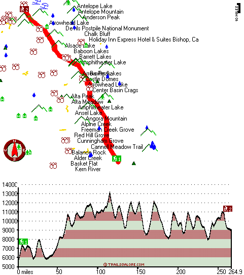
Total hiking length = 264.9 miles
Total climbing distance = 124.4 miles
Difficulty : Difficult
Casual Hiking Pace:
40.5 days
Fast Hiking Pace:
22.5 days
Trailhead 2 to Trailhead 1:
Total hiking length = 264.9 miles
Total climbing distance = 132.4 miles
Difficulty : Difficult
Casual Hiking Pace:
41.5 days
Fast Hiking Pace:
23 days
| | Trailhead 1 back to Trailhead 1:
Total hiking length = 529.8 miles
Total climbing distance = 256.8 miles
Difficulty : Difficult
Casual Hiking Pace:
82 days
Fast Hiking Pace:
54.5 days
Trailhead 2 back to Trailhead 2:
Total hiking length = 529.8 miles
Total climbing distance = 256.8 miles
Difficulty : Difficult
Casual Hiking Pace:
82 days
Fast Hiking Pace:
54.5 days
|
Total elevation difference: 9028 feet
|


