| |
The total elevation difference for Pacific Crest Trail - section 10 is 3,777 feet which is a higher than average number. Now this backcountry trail is pretty long, so don't forget to pack enough supplies. There are two trailheads to chose from, one in each end, so if you can get a ride from someone, you can backcountry hike it just one way. Of course, this is an overnight hike, 21 days normally, so better have big a backpack to fit all the stuff you need. Different parts of Pacific Crest Trail - section 10 are at very different elevations, and that means that some parts of the backpacking trail could be very different from other parts of it. At parts of the year this neighborhood sees very little rain, so do check for current fire restrictions before you go if you plan to bring a stove or make a camp fire. With its 135.6 miles of walking distance; it's considered a longer walk.
|
Trailhead 1 to Trailhead 2:
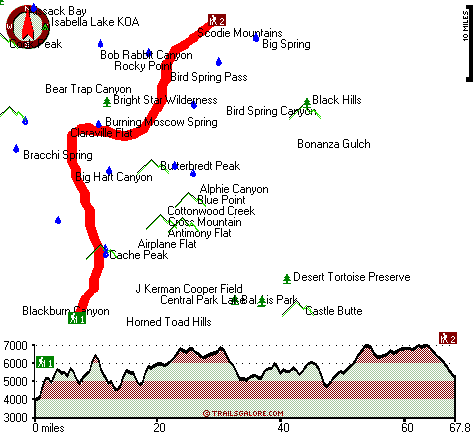
Total hiking length = 67.8 miles
Total climbing distance = 35.6 miles
Difficulty : Difficult
Casual Hiking Pace:
11 days
Fast Hiking Pace:
6 days
Trailhead 2 to Trailhead 1:
Total hiking length = 67.8 miles
Total climbing distance = 28.6 miles
Difficulty : Difficult
Casual Hiking Pace:
10 days
Fast Hiking Pace:
5.5 days
| | Trailhead 1 back to Trailhead 1:
Total hiking length = 135.6 miles
Total climbing distance = 64.2 miles
Difficulty : Difficult
Casual Hiking Pace:
21 days
Fast Hiking Pace:
13.5 days
Trailhead 2 back to Trailhead 2:
Total hiking length = 135.6 miles
Total climbing distance = 64.2 miles
Difficulty : Difficult
Casual Hiking Pace:
21 days
Fast Hiking Pace:
13.5 days
|
Total elevation difference: 3777 feet
|


