| |
|
| | Gotta get out of the settlement man, and Pacific Crest Trail - section 3 in overlapping counties, California is just the spot. California is a tremendous outdoors state. Going for a backcountry trek here in California is so much fun. Now, this is roughly a 17.5-day backcountry trek, so better have big backpack to fit all the stuff you need. There are two trailheads to chose from, one in each end which means you have the option of backpacking it one way if you have someone to pick you up at the other end. This is one of many wilderness trails in the surrounding |
|
region. A long journey separates San Diego-Carlsbad-San Marcos from Pacific Crest Trail - section 3, but many people like to hike here to be right next door to the outdoors. At Pacific Crest Trail - section 3 during the warmest time of the year highs are in the 80's. For the duration
| | of the moonlight hours it's ordinarily in the 60's. For the duration of the winter highs are in the 50's, and night lows in the 30's for Pacific Crest Trail - section 3. Being 113.6 miles long; it's considered a longer backcountry walk. This trail is a trail of good length with an average amount of climbing distance which makes this wilderness trail delightful for hard core backpackers looking for adventure. Pacific Crest Trail - section 3 has a total elevation difference of 3,921 feet which is higher than average. Please follow all local rules about | |
|
fires and camping. Pacific Crest Trail - section 3 is a location that is quite waterless generally; the month with most of the rain is February while June is generally the driest month. Great outdoors hiking trails are delightful and plentiful in California; Pacific Crest Trail
- section 3 is one of them, and it's in overlapping counties. Sometimes this trail gets really dry, so make sure you check current conditions and fire restrictions with local forest authorities before you head out. There are plenty of backpacking trails in California; each one
of them has its own unique prettiness. Pacific Crest Trail - section 3 is quite long, so don't forget to pack enough supplies. Backcountry hiking here in the Santa Rosa Mountains is a very good way to see these summits. Different parts of Pacific Crest Trail - section 3 are at
very different elevations, and that means that some parts of the wilderness trail could be very different from other parts of it.
Briefly about the general area: Whohoo, so much entertaining stuff in one place! Pacific Crest Trail - section 3 is excellent! A fine place
to camp here at Pacific Crest Trail - section 3 is Los Coyotes Reservation Campground, and hey, Dry Wash is a glorious local stream. Yeah, come up here to the Santa Rosa Mountains for a great time. While you're here at Pacific Crest Trail - section 3 you ought to take a look at
Panorama Outlook, and swing by Canada Buena Vista it's a brilliant site to visit. Camping is available at Borrego Palm Canyon Campground, and Upper Willows is a nice forest neighborhood nearby. Don’t forget to take a look at Bennis Bowl since you're here at Pacific Crest Trail
- section 3; a spree to By Jim Spring will fill your soul with great feelings. Be careful coming to the Santa Rosa Mountains, you might not ever wanna go home again. Nearby Box Canyon is a delightful site to go if you're at Pacific Crest Trail - section 3. Don't leave Pacific
Crest Trail - section 3 without first paying a visit to Blackwater Hole; you ought to without doubt dedicate some time to Lower Willows if you're here at Pacific Crest Trail - section 3.
|
|
Location of Trailhead 1: Latitude 33.0963, Longitude -116.4622 - - Directions and Road Map
Location of Trailhead 2: Latitude 33.5674, Longitude -116.5739 - - Directions and Road Map

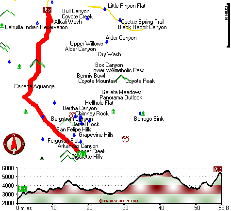
Trailhead 1 to Trailhead 2: Total hiking length = 56.8 miles Total climbing distance = 29 miles Difficulty : Difficult Casual Hiking Pace:
9 days
Fast Hiking Pace:
5 days
Trailhead 2 to Trailhead 1: Total hiking length = 56.8 miles Total climbing distance = 25.2 miles Difficulty : Difficult Casual Hiking Pace:
8.5 days
Fast Hiking Pace:
4.5 days
| | Trailhead 1 back to Trailhead 1: Total hiking length = 113.6 miles Total climbing distance = 54.2 miles Difficulty : Difficult Casual Hiking Pace:
17.5 days
Fast Hiking Pace:
11.5 days
Trailhead 2 back to Trailhead 2: Total hiking length = 113.6 miles Total climbing distance = 54.2 miles Difficulty : Difficult Casual Hiking Pace:
17.5 days
Fast Hiking Pace:
11.5 days
|
Total elevation difference: 3921 feet

Stanlunds Resort Inn And Suites, Borrego Springs
|
10 miles away
Stanlunds Resorts situated in the heart of Anza Borrego Desert State Park,was built in 50's has been remodelled in Feb 2005. A very quiet and peaceful place. Not too much traffic, a relaxing area wi...
|
| |
|
User input for Pacific Crest Trail - section 3, Santa Rosa Mountains, overlapping counties, California:

Outdoors Recreation Near San Diego-Carlsbad-San Marcos, California Very comprehensive list of a variety of outdoors recreation in the vicinity of San Diego-Carlsbad-San Marcos, California, the metro area neareast to Pacific Crest Trail - section 3. Find info on campgrounds, hiking trails, ski resorts, lakes, beaches, parks, whitewater and more.
More Hotels and Campgrounds Near Pacific Crest Trail - section 3, Santa Rosa Mountains, overlapping counties, California
| |
| |
 |
|
| These outdoors activities are available near Pacific Crest Trail - section 3. |
| | Trails Near Pacific Crest Trail - section 3:
 |
Cactus Spring Trail, Riverside County
counties
, 15 miles away, 28.8 hiking miles, 4178 feet elevation difference |
 |
Ramona Trail, Riverside County
counties
, 20 miles away, 3.2 hiking miles, 1792 feet elevation difference |
 |
Pacific Crest Trail - section 2, County
counties
, 21 miles away, 35.3 hiking miles, 4125 feet elevation difference |
 |
Middle Peak Loop Trail, San Diego County
counties
, 22 miles away, 2.6 hiking miles, 620 feet elevation difference |
 |
Pacific Crest Trail - section 4, County
counties
, 25 miles away, 55.3 hiking miles, 9055 feet elevation difference |
 |
Monument Trail, San Diego County
counties
, 25 miles away, 1.3 hiking miles, 974 feet elevation difference |
 |
Aguanga Trail, San Diego County
counties
, 26 miles away, 5.2 hiking miles, 1624 feet elevation difference |
|
| | Whitewater Near Pacific Crest Trail - section 3:
 |
Santa Margarita River, San Diego County
counties
, 49 miles away, Class IV(V) - 9 miles long (Murrieta Creek to Sandia Creek Road) |
 |
Escondido Creek, San Diego County
counties
, 50 miles away, Class III-IV - 6.6 miles long (San Elijo Canyon: Elfin Forest Preserve to Camino Del NoRoute Road) |
 |
Los Penasquitos Creek, San Diego County
counties
, 52 miles away, Class III+(V+) - 9 miles long (I-15 to I-5) |
 |
Piru Creek, Ventura County
counties
, 169 miles away, Class II - 4 miles long (Lake Piru to Santa Clara River) |
 |
Piru Creek, Los Angeles / Ventura County
counties
, 172 miles away, Class IV - 15 miles long (Pyramid Lake to Lake Piru) |
|
| | Hotels Near Pacific Crest Trail - section 3:
 |
Stanlunds Resort Inn And Suites, Borrego Springs
, 10 miles away |
 |
Borrego Springs Resort And Country Club, Borrego Springs
, 11 miles away |
 |
La Casa del Zorro, Borrego Springs
, 13 miles away |
 |
MOJAVE RESORT, Palm Desert
, 23 miles away |
 |
Fairfield Inn By Marriott Palm Desert, Palm Desert
, 23 miles away |
|
|
|
 |
|