Washington hiking trails - West Wenatchee Trail, Blue Mountains, Asotin County

   
  Every single Washington backcountry trail has its own unique loveliness. West Wenatchee Trail is a long tour away from Pullman, but when you backcountry hike it you're always having a splendid time. There are so many wonderful backcountry trails for trekking in Washington, and one of these is West Wenatchee Trail in Asotin County. This hiking trail sometimes gets very dry, so don’t forget to check for any current fire restrictions before you go. At West Wenatchee Trail you don’t see much rainfall; during January this region sees the most rain, and July
    is when it's the driest. This wilderness trail has only one trailhead, so you'll be hiking it in and back out. West Wenatchee Trail is 6.4 miles long it's an average length hiking trail. When you're here in Washington trekking along one of its backcountry trails is the wonderful
thing to do. Great outdoors trails like this one here in the Blue Mountains are a really pleasant way to spend quality time in the outdoors. Throughout the long summer days, highs mostly are in the 80's at West Wenatchee Trail with night lows in the 50's. For the period of the wintertime highs are frequently in the 40's while West Wenatchee Trail night low temperatures through the wintertime are in the 20's. Washington has lots of outdoors endeavors. Time to get out, and breathe some fresh air, and West Wenatchee Trail in Asotin County, Washington is  
a splendid selection. The length of West Wenatchee Trail is about average having an average number of uphill miles which makes this backpacking trail fine for hard core backpackers looking for adventure. Don’t forget to check for any current restrictions or closures before you go. The total elevation difference for this wilderness trail is 2,178 feet which is about average. This is a hiking trail that is quite long, so don't forget to pack enough supplies. This trek shouldn't take more than 5.5 hours, but of course some folks walk a bit slower and some a bit faster. Different parts of this hiking trail are at very different elevations, and that means that some parts of the hiking trail could be very different from other parts of it. This is one of many backpacking trails in the surrounding area.

Briefly about the general area:
Bucket Spring is an inspiring place to stop by while here, and the beauty of mother nature reveals herself at Grouse Spring. All the outdoors amusing stuff in the Blue Mountains will keep you coming back many times. West Fork Grouse Creek is a stream that you may run into while here; a nice place to camp here at West Wenatchee Trail is Wickiup Campground.
Whitewater paddling is not for everybody but if it's for you then we recommend Grande Ronde River, and why not camp at Misery Spring Campground since you're here at West Wenatchee Trail. East Fork Grouse Creek flows through this region; close by you stumble on magnificent places like Little Saddle. You assume that's enough? Just getting warmed up.

Location of Trailhead: Latitude 46.0816, Longitude -117.4642
- - Directions and Road Map

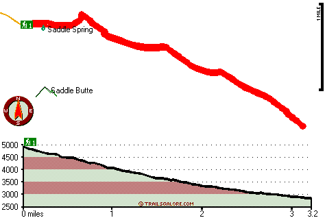
Total in and out hiking length = 6.4 miles

Total climbing distance = 2.6 miles

Difficulty : Difficult

Casual Hiking Pace: 5.5 hours

Fast Hiking Pace: 3.5 hours

Total elevation difference: 2178 feet


Best Western Rivertree Inn, Clarkston
31 miles away
Stay at this Clarkston hotel and experience an exceptional staff and comfortable accommodations near Washington State's key area attractions and business locations. Located at the Gateway to Hell's C...
  
Quality Inn & Suites Conference Center, Clarkston
32 miles away
The Quality Inn and Suites features a restaurant on premise with free full hot breakfast each morning for each registered adult. All rooms are newly renovated and come with a microwave, refrigerator, ...
User input for West Wenatchee Trail, Blue Mountains, Asotin County, Washington:

Submit Input:
Your Name:
Write or Paste Input here:

Upload picture:      Review Guidelines


Outdoors Recreation Near Pullman, Washington
Very comprehensive list of a variety of outdoors recreation in the vicinity of Pullman, Washington, the metro area neareast to West Wenatchee Trail. Find info on campgrounds, hiking trails, ski resorts, lakes, beaches, parks, whitewater and more.

Current weather conditions at West Wenatchee Trail, Blue Mountains, Asotin County, Washington
WXPort

Local climate location: POMEROY 11 miles away

Best Western Rama Inn & Suites, Enterprise
33 miles away
This full-service Enterprise, Oregon hotel is minutes away from local attractions and is an ideal weekend getaway from busy everyday life. Enjoy a peaceful and relaxing getaway to Northwestern Orego...

Guesthouse Lewiston, Lewiston
34 miles away
Located in Downtown District with a wonderful flare of Historic Tasteful Lewiston. Surrounded by shopping, restaurants, and night life. Greenbelt and Snake River behind hotel or rollerblading, biking,...

More Hotels and Campgrounds Near West Wenatchee Trail, Blue Mountains, Asotin County, Washington

OTHER_INFO
  Blue Mountains Campgrounds
Complete list of all the campgrounds in the Blue Mountains.

Blue Mountains Outdoors Info
Complete outdoors info for the Blue Mountains.

Washington Hiking Trails
Complete list of all hiking trails in Washington

Books about hiking trails in Washington
List of books available on Amazon.com about hiking trails in Washington.

Washington Outdoors Index
This is a very comprehensive index of outdoors activities in the great state of Washington.


TOPO
High quality water resistant topo map of West Wenatchee Trail, Blue Mountains, Asotin County, Washington.

OUTDOORS_GUIDE
These outdoors activities are available near West Wenatchee Trail.
 Trails Near West Wenatchee Trail:
Wenatchee Creek Trail, Asotin County County , 4 miles away, 8.5 hiking miles, 3641 feet elevation difference
July Ridge Trail, Garfield County County , 5 miles away,  5.4 hiking miles, 2063 feet elevation difference
Low Saddle Trail, Asotin County County , 5 miles away,  11.2 hiking miles, 1856 feet elevation difference
Indian Tom Trail, Asotin County County , 5 miles away,  5.4 hiking miles, 2258 feet elevation difference
North Fork Asotin Creek Trail, Garfield County County , 7 miles away, 8.9 hiking miles, 2760 feet elevation difference
Red Hill Gulch Trail, Asotin County County , 7 miles away, 3.3 hiking miles, 1987 feet elevation difference
Melton Creek Trail, Garfield County County , 8 miles away,  16.4 hiking miles, 4283 feet elevation difference
 Camp Grounds Near West Wenatchee Trail:
Wickiup Campground, Garfield County, 3 miles away
Misery Spring Campground, Garfield County, 4 miles away
Spruce Spring Campground, Garfield County, 9 miles away
Big Spring Campground, Garfield County, 10 miles away
Pataha Campground, Garfield County, 12 miles away
 Whitewater Near West Wenatchee Trail:
Grande Ronde River, Asotin County County , 7 miles away, Class II-III - 19.5 miles long (Troy to Boggan's Oasis)
 Hotels Near West Wenatchee Trail:
Best Western Rivertree Inn, Clarkston , 31 miles away
Quality Inn & Suites Conference Center, Clarkston , 32 miles away
Best Western Rama Inn & Suites, Enterprise , 33 miles away
Guesthouse Lewiston, Lewiston , 34 miles away
Lewiston Inn & Suites, Lewiston , 34 miles away

Outdoors related information copyright © Stratus-Pikpuk, Inc. - Detailed hotel information copyright © Interactive Hotel Solutions