Washington hiking trails - West Fork Methow Trail, Northern Cascade Range, Okanogan County

   
  Wilderness hiking trails are pleasant and plentiful in Washington; one of them being West Fork Methow Trail in Okanogan County. Washington is a tremendous outdoors state. Each wilderness trail in Washington is well worth a backcountry hike. Backpacking here in Washington is a tremendous way to spend some time. West Fork Methow Trail being so distant from the nearest settlement, backpacking trails like these are splendid. Now, this is roughly a 2-day walk, so it's a glorious thing if your backpack is big enough to do the job. West Fork Methow Trail is
    a very long hiking and backpacking trail with an average amount of climbing distance which makes this a very tough great outdoors hiking trail for advanced trekkers looking for a nice challenge. At parts of the year this neighborhood sees very little rain, so make sure you check
current conditions and fire restrictions with local forest authorities before you head out. Please follow all local rules about fires and camping. West Fork Methow Trail is a wonderful place of typical precipitation; throughout the month of December you get the most snow around here, and the driest month is July. There are so many great outdoors hiking trails in this vicinity. This is a long backpacking trail, so do pack enough food to last the whole trip. This backcountry hiking trail goes through some very different elevations which of course means  
you need to be prepared for different conditions on different parts of the backcountry hiking trail. Put on your backcountry hiking shoes, and hit the backpacking trail, West Fork Methow Trail in Okanogan County, Washington is a glorious location to go. At West Fork Methow Trail through the summer highs are in the 80's while overnight lows are commonly in the 50's. The cold days of the winter come with highs in the 30's; overnight lows at West Fork Methow Trail during the winter commonly sink into the 20's. Backpacking here in the Northern Cascade Range is the best way to enjoy these mountains. With its 14.4 miles of walking distance; it's considered a longer backcountry hike. West Fork Methow Trail has only one trailhead, so you're looking at an in and out backcountry trek. This hiking trail has a total elevation difference of 1,890 feet which is an average number.

Briefly about the general area:
There's so much to do here at West Fork Methow Trail that you need to camp here for a while, Meadows Campground is a glorious place for that, and a quick spree to Arralde Creek is certainly a nice idea. You clearly must go for West Fork Methow Trail. Get yourself into a kayak and hit Lost River.
A tour to Deadhorse Point close to West Fork Methow Trail is always a brilliant idea, and do set aside some time for Ninetynine Basin while you're here at West Fork Methow Trail. It's a wonderful idea to go to Rattlesnake Creek, it's in the vicinity of West Fork Methow Trail; if you come at the right time of year, Canyon Creek - Skagit Tributary offers some perfect whitewater. Not enough hours in a day to enjoy the Northern Cascade Range. West Fork Methow Trail is tremendous enough to spend more than a day at, Rattlesnake Campground is a tremendous local campground; a fine site close by is Harts Pass.

Location of Trailhead: Latitude 48.6479, Longitude -120.5673
- - Directions and Road Map

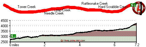
Total in and out hiking length = 14.4 miles

Total climbing distance = 5.8 miles

Difficulty : Difficult

Casual Hiking Pace: 2 days

Fast Hiking Pace: 8 hours

Total elevation difference: 1890 feet


Adventure Inn, Leavenworth
48 miles away
Convenience and comfort are hallmarks for the Adventure Inn. Located in downtown Leavenworth but one block removed from the noise of Hwy 2 and the bustle of Front Street. Ample parking and elevator ac...
  
Bavarian Ritz, Leavenworth
48 miles away
Experience romance Bavarian Style @ bavarianritz.com, check our website for our rooms, rates, and seasonal specials, in one of the most romantic hotel in downtown Leavenworth. Set in the heart of down...
User input for West Fork Methow Trail, Northern Cascade Range, Okanogan County, Washington:

Submit Input:
Your Name:
Write or Paste Input here:

Upload picture:      Review Guidelines


Outdoors Recreation Near Wenatchee, Washington
Very comprehensive list of a variety of outdoors recreation in the vicinity of Wenatchee, Washington, the metro area neareast to West Fork Methow Trail. Find info on campgrounds, hiking trails, ski resorts, lakes, beaches, parks, whitewater and more.

Current weather conditions at West Fork Methow Trail, Northern Cascade Range, Okanogan County, Washington
WXPort

Local climate location: STEHEKIN 24 miles away

Howard Johnson Express Inn - Leavenworth, Leavenworth
48 miles away
* Gold medal Award Winning Property * Weekly Rates available for a limited time * Beautiful scenery reminiscent of the Swiss Alps * Two blocks to the Authentic Bavarian Village * Old World Charm, Qua...

Quality Inn & Suites, Leavenworth
48 miles away
The Quality Inn & Suites hotel is located just one mile from the Wenatchee National Forest, which extends along the east side of the Cascade Mountains. The hotel is located 100 miles east of Seattle. ...

More Hotels and Campgrounds Near West Fork Methow Trail, Northern Cascade Range, Okanogan County, Washington

OTHER_INFO
  Northern Cascade Range Campgrounds
Complete list of all the campgrounds in the Northern Cascade Range.

Northern Cascade Range Outdoors Info
Complete outdoors info for the Northern Cascade Range.

Washington Hiking Trails
Complete list of all hiking trails in Washington

Books about hiking trails in Washington
List of books available on Amazon.com about hiking trails in Washington.

Washington Outdoors Index
This is a very comprehensive index of outdoors activities in the great state of Washington.


TOPO
High quality water resistant topo map of West Fork Methow Trail, Northern Cascade Range, Okanogan County, Washington.

OUTDOORS_GUIDE
These outdoors activities are available near West Fork Methow Trail.
 Trails Near West Fork Methow Trail:
Driveway Butte Trail, Okanogan County County , 8 miles away,  9.4 hiking miles, 3442 feet elevation difference
Monument Creek Trail, Okanogan County County , 10 miles away,  29.8 hiking miles, 4673 feet elevation difference
Rainbow Lake Trail, Chelan County County , 13 miles away,  24.8 hiking miles, 6260 feet elevation difference
Mill Creek Trail, Whatcom County County , 14 miles away,  29.4 hiking miles, 5463 feet elevation difference
 Camp Grounds Near West Fork Methow Trail:
Meadows Campground, Okanogan County, 4 miles away
Rattlesnake Campground, Okanogan County, 5 miles away
Rivers Bend Campground, Okanogan County, 6 miles away
Ballard Campground, Okanogan County, 6 miles away
Klipchuck Campground, Okanogan County, 9 miles away
 Whitewater Near West Fork Methow Trail:
Lost River, Okanogan County County , 14 miles away, Class IV-V - 12 miles long (Drake Creek to Methow River confluence)
Canyon Creek - Skagit Tributary, Whatcom County County , 16 miles away, Class IV-V - 6.7 miles long (Slate Creek to Granite Creek)
Stehekin River, Chelan County County , 16 miles away, Class II(IV) - 10 miles long (Agnes Creek to Lake Chelan)
Granite Creek, Skagit/whatcom County County , 16 miles away, Class IV-V(V+) - 4.6 miles long (Highway 20 to Beebe Creek)
Granite Creek, Whatcom County County , 21 miles away, Class IV - 5 miles long (Beebe Creek to Panther Creek)
 Hotels Near West Fork Methow Trail:
Adventure Inn, Leavenworth , 48 miles away
Bavarian Ritz, Leavenworth , 48 miles away
Howard Johnson Express Inn - Leavenworth, Leavenworth , 48 miles away
Quality Inn & Suites, Leavenworth , 48 miles away
Best Western Icicle Inn, Leavenworth , 48 miles away

Outdoors related information copyright © Stratus-Pikpuk, Inc. - Detailed hotel information copyright © Interactive Hotel Solutions