Washington hiking trails - Twentyeight Mile Creek Trail, Northern Cascade Range, Pierce County

   
  Wilderness hiking trails are great and plentiful in Washington, and among these are Twentyeight Mile Creek Trail in Pierce County. A visit to Washington is not complete without some backcountry backpacking. We all need to get out in the fresh air once in a while, and Twentyeight Mile Creek Trail in Pierce County, Washington is just what you need. Now, this is roughly a 3-day backcountry hike, so better have big backpack to fit all the stuff you need. This wilderness hiking trail goes through some very different elevations, so keep in mind that you may
    need to dress differently at different elevations. The backpacking and hiking trails of the Northern Cascade Range are the best way to enjoy these hills. With its 18.6 miles of walking distance; it's longer than many wilderness hiking trails. During the summer months at Twentyeight
Mile Creek Trail temperatures are generally in the 70's. During the dark hours of summer temperatures dip down into the 50's. During the wintertime this place gets highs in the 40's, and night lows during the wintertime for Twentyeight Mile Creek Trail tend to be in the 30's. Twentyeight Mile Creek Trail is a relatively wet place generally with a large amount of precipitation; November is when you get the most rain here while July is regularly the driest month. Keep in mind that this is a long hiking and backpacking trail, so do pack enough food to last the whole  
trip. Twentyeight Mile Creek Trail is a two ended hiking trail with two trailheads, so backcountry trekking it one way is an option if you can arrange for a ride back. This is just one of a large number of great outdoors hiking trails in this area. Because Twentyeight Mile Creek Trail is very secluded from civilization, it's one of those places where trekking is wonderful. If you happen to be in Washington, why not go backpacking, it is so much fun. Please follow all local rules about fires and camping. Twentyeight Mile Creek Trail is many miles long having an average number of uphill miles which makes this great outdoors hiking trail great for hard core backpackers looking for adventure. Every hiking and backpacking trail in Washington is worth backpacking. 
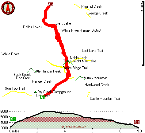
The total elevation difference for Twentyeight Mile Creek Trail is 3,558 feet which is higher than average.

Briefly about the general area:
You simply should go for Twentyeight Mile Creek Trail. If you came for an overnight stay Dry Creek Campground is a good place to camp It's always glorious to explore Mule Spring. Whohoo, so many enjoyable things in one place! The Northern Cascade Range is excellent! Big Crow Basin is a lovely location any time of year, and a trip to Silver Springs will fill your spirit with delightful feelings.
Get your heart pumping on the delightful whitewater of White River, and obviously Dry Creek flows through this area. Bear Park is a pleasant site to stretch your legs a bit, and some magnificent nature is available in White River Ranger District. Now, you may feel that's lots but there's even more cool things to do here in the Northern Cascade Range. A perfect spot for whitewater paddling near Twentyeight Mile Creek Trail is Greenwater River; a quick visit to Ranger Creek is positively a glorious idea.
Nearby Corral Pass is a splendid place to go if you're at Twentyeight Mile Creek Trail, and camping at Twentyeight Mile Creek Trail is delightful fun, The Dalles Campground is a delightful local campground.

Location of Trailhead 1: Latitude 47.0067, Longitude -121.5202
- - Directions and Road Map

Location of Trailhead 2: Latitude 47.1112, Longitude -121.5112
- - Directions and Road Map


Trailhead 1 to Trailhead 2:
Total hiking length = 9.3 miles
Total climbing distance = 3.4 miles
Difficulty : Difficult
Casual Hiking Pace: 8 hours
Fast Hiking Pace: 4.5 hours

Trailhead 2 to Trailhead 1:
Total hiking length = 9.3 miles
Total climbing distance = 4.5 miles
Difficulty : Difficult
Casual Hiking Pace: 8.5 hours
Fast Hiking Pace: 5 hours
    Trailhead 1 back to Trailhead 1:
Total hiking length = 18.6 miles
Total climbing distance = 7.9 miles
Difficulty : Difficult
Casual Hiking Pace: 3 days
Fast Hiking Pace: 2 days

Trailhead 2 back to Trailhead 2:
Total hiking length = 18.6 miles
Total climbing distance = 7.9 miles
Difficulty : Difficult
Casual Hiking Pace: 3 days
Fast Hiking Pace: 2 days

Total elevation difference: 3558 feet


Salish Lodge And Spa, Snoqualmie
31 miles away
Original Snoqualmie Lodge built atop the Falls in 1916 was a logging route stopover famous for its lumberjack breakfast. The original Lodge had only 5 guestrooms. Building on the existing lodge and in...
  
Kings Value Inn - Enumclaw, Wa, Enumclaw
31 miles away
Kings Valu Inn **Free Wireless Internet - Outdoor Seasonal Pool - In-Room Coffee - Quality Rooms** Kings Valu Inn is the complete home away from home for your traveling convenience. Stay for a day, a ...
User input for Twentyeight Mile Creek Trail, Northern Cascade Range, Pierce County, Washington:

Submit Input:
Your Name:
Write or Paste Input here:

Upload picture:      Review Guidelines


Outdoors Recreation Near Seattle-Tacoma-Bellevue, Washington
Very comprehensive list of a variety of outdoors recreation in the vicinity of Seattle-Tacoma-Bellevue, Washington, the metro area neareast to Twentyeight Mile Creek Trail. Find info on campgrounds, hiking trails, ski resorts, lakes, beaches, parks, whitewater and more.

Current weather conditions at Twentyeight Mile Creek Trail, Northern Cascade Range, Pierce County, Washington
WXPort

Local climate location: MUD MOUNTAIN DAM 3 miles away

Summit Lodge at Snoqualmie Pass, Snoqualmie Pass
33 miles away
The Summit Lodge is located near the base of the Summit Ski Resort, and it is perfectly located for year-round outdoor activities. Summit Lodge's two-story layout showcases 81 rooms and three conferen...

The Governor Hotel, Olympia
33 miles away
Situated in the heart of beautiful downtown Olympia, The Governor Hotel overlooks both Capitol Lake and Sylvester Park....

More Hotels and Campgrounds Near Twentyeight Mile Creek Trail, Northern Cascade Range, Pierce County, Washington

OTHER_INFO
  Northern Cascade Range Campgrounds
Complete list of all the campgrounds in the Northern Cascade Range.

Northern Cascade Range Outdoors Info
Complete outdoors info for the Northern Cascade Range.

Washington Hiking Trails
Complete list of all hiking trails in Washington

Books about hiking trails in Washington
List of books available on Amazon.com about hiking trails in Washington.

Washington Outdoors Index
This is a very comprehensive index of outdoors activities in the great state of Washington.


TOPO
High quality water resistant topo map of Twentyeight Mile Creek Trail, Northern Cascade Range, Pierce County, Washington.

OUTDOORS_GUIDE
These outdoors activities are available near Twentyeight Mile Creek Trail.
 Trails Near Twentyeight Mile Creek Trail:
Dalles Ridge Trail, Pierce County County , 2 miles away,  4.8 hiking miles, 558 feet elevation difference
Lost Lake Trail, Pierce County County , 3 miles away,  12 hiking miles, 2942 feet elevation difference
Sun Top Trail, Pierce County County , 4 miles away, 7 hiking miles, 3225 feet elevation difference
Castle Mountain Trail, Pierce County County , 4 miles away,  3 hiking miles, 591 feet elevation difference
Naches Pass-Greenwater Trail, King County County , 5 miles away, 3.7 hiking miles, 2261 feet elevation difference
Greenwater Trail, Pierce County County , 5 miles away,  9.2 hiking miles, 1028 feet elevation difference
Rock Creek Trail, King County County , 6 miles away, 4.4 hiking miles, 2923 feet elevation difference
 Camp Grounds Near Twentyeight Mile Creek Trail:
Dry Creek Campground, Pierce County, 2 miles away
The Dalles Campground, Pierce County, 5 miles away
Morse Creek Campground, Yakima County, 10 miles away
White River Campground, Pierce County, 11 miles away
Lodgepole Campground, Yakima County, 12 miles away
 Whitewater Near Twentyeight Mile Creek Trail:
White River, Pierce County County , 4 miles away, Class III - 10 miles long (Silver Springs Campground to West Fork White)
Greenwater River, Pierce/King County County , 6 miles away, Class II(IV) - 7.2 miles long (FR 7030 Bridge to Highway 410)
Chinook Creek, Pierce County County , 12 miles away, Class IV-V - 5 miles long (Deer Creek to Cedar Flats)
White River, Pierce County County , 14 miles away, Class III - 13.5 miles long (West Fork to Bridge Camp)
American River, -blank- County County , 14 miles away, Class II-III+ - 7.5 miles long (Lodgepole Campground to Hell's Crossing)
 National Parks Near Twentyeight Mile Creek Trail:
Mount Rainier National Park, Ashford - WA , 35 miles away
 Hotels Near Twentyeight Mile Creek Trail:
Salish Lodge And Spa, Snoqualmie , 31 miles away
Kings Value Inn - Enumclaw, Wa, Enumclaw , 31 miles away
Summit Lodge at Snoqualmie Pass, Snoqualmie Pass , 33 miles away
The Governor Hotel, Olympia , 33 miles away
Suncadia Resort, Cle Elum , 36 miles away
 Lakes Near Twentyeight Mile Creek Trail
Twentyeight Mile Lake, Pierce County , 1 miles away
Forest Lake, Pierce County , 2 miles away

Outdoors related information copyright © Stratus-Pikpuk, Inc. - Detailed hotel information copyright © Interactive Hotel Solutions