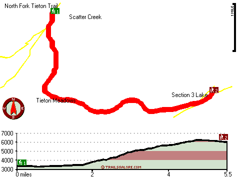
Washington hiking trails - Tieton Meadows Trail, Northern Cascade Range, Yakima County

   
  Backcountry hiking in Washington is an outstanding idea. Hey, time for a walk don’t you think? if you happen to be in Yakima County of Washington, Tieton Meadows Trail is a glorious local wilderness trail for doing a bit of leg stretching. There are great outdoors hiking trails all over Washington, and Tieton Meadows Trail in Yakima County is one of them. This is a great outdoors trail that is quite long, so do pack enough food to last the whole trip. There are numerous great outdoors hiking trails in Washington, and each one is stunning in its own way.
    Tieton Meadows Trail has two trailheads, so if you can get a ride from someone, you can backcountry trek it just one way. The total elevation difference for Tieton Meadows Trail is 3,251 feet which is higher than average. Now, this is roughly a 1.5-day trek, so it's a wonderful
thing if your backpack is big enough to do the job. Being 11 miles long; it's longer than many backcountry hiking trails. Tieton Meadows Trail generally gets lots of rain; January is when you get the most snow here, and the driest month of the year is July. Tieton Meadows Trail is very far from the most adjacent large urban center, and backcountry backpacking it is always enjoyable. This is just one of a large number of hiking and backpacking trails in this neighborhood. In Washington you never run out of outdoors fun. Different parts of Tieton Meadows  
Trail are at very different elevations, so keep in mind that you may need to dress differently at different elevations. And keep in mind that there could be temporary safety restrictions in place. These hiking and backpacking trails here in the Northern Cascade Range are the best way to enjoy these mountaintops. This hiking and backpacking trail is a very long hiking and backpacking trail with an average amount of climbing distance which makes this hiking and backpacking trail good for hard core backpackers looking for adventure. Summer brings highs in the 60's to Tieton Meadows Trail, and the nighttime is a bit chillier of course, generally in the 40's. Daytime highs through the wintertime are in the 30's with winter lows in the 10's overnight here at Tieton Meadows Trail.

Briefly about the general area:
Not enough hours in a day to enjoy the Northern Cascade Range. A journey to Hidden Spring will fill your soul with pleasant feelings. But wait, there's more exciting things to do in the Northern Cascade Range. Tieton Meadows is a nice site to stretch your legs a bit, and in the event that you don't mind getting soaked, you can always go whitewater paddling on Cispus River.
Devils Washbasin is a lovely site any time of year; why not camp at Knuppenburg Lake Campground while you're here at Tieton Meadows Trail. Coming to this river is always a good idea. Miriam Creek is a stream that you may run into during your stay, and Tieton River - South Fork is a pleasant whitewater spot close by. This spot is great, just check out all the cool things to do in the vicinity of Tieton Meadows Trail. It's always perfect to pop by Indian Spring, and obviously Scatter Creek flows through this region.
White Pass is a glorious place to take a look at in the neighborhood of Tieton Meadows Trail, and a nice spot to camp here at Tieton Meadows Trail is White Pass Campground.

Location of Trailhead 1: Latitude 46.5801, Longitude -121.3579
- - Directions and Road Map

Location of Trailhead 2: Latitude 46.5566, Longitude -121.3107
- - Directions and Road Map


Trailhead 1 to Trailhead 2:
Total hiking length = 5.5 miles
Total climbing distance = 3.2 miles
Difficulty : Medium
Casual Hiking Pace: 5.5 hours
Fast Hiking Pace: 3 hours

Trailhead 2 to Trailhead 1:
Total hiking length = 5.5 miles
Total climbing distance = .8 miles
Difficulty : Easy
Casual Hiking Pace: 4 hours
Fast Hiking Pace: 2 hours
    Trailhead 1 back to Trailhead 1:
Total hiking length = 11 miles
Total climbing distance = 4 miles
Difficulty : Difficult
Casual Hiking Pace: 1.5 days
Fast Hiking Pace: 6 hours

Trailhead 2 back to Trailhead 2:
Total hiking length = 11 miles
Total climbing distance = 4 miles
Difficulty : Difficult
Casual Hiking Pace: 1.5 days
Fast Hiking Pace: 6 hours

Total elevation difference: 3251 feet


Suncadia Resort, Cle Elum
38 miles away
Set on the sunny eastern slopes of the Cascades alongside the sparkling waters of the Cle Elum River and surrounded by pristine pine forest-Suncadia offers the ultimate luxury mountain resort experien...
  
Stewart Lodge, Cle Elum
40 miles away
The Stewart Lodge offers a wide range of rooms and amenities to make us your recreational or business spot all year around. Our rooms are exceptionally large and include unique pine furniture, microw...
User input for Tieton Meadows Trail, Northern Cascade Range, Yakima County, Washington:

Submit Input:
Your Name:
Write or Paste Input here:

Upload picture:      Review Guidelines


Outdoors Recreation Near Hood River, Oregon
Very comprehensive list of a variety of outdoors recreation in the vicinity of Hood River, Oregon, the metro area neareast to Tieton Meadows Trail. Find info on campgrounds, hiking trails, ski resorts, lakes, beaches, parks, whitewater and more.

Current weather conditions at Tieton Meadows Trail, Northern Cascade Range, Yakima County, Washington
WXPort

Local climate location: RAINIER PARADISE R S 8 miles away

Best Western Snowcap Lodge, Cle Elum
40 miles away
The contemporary Best Western Snowcap Lodge is centrally located on the eastern slopes of the cascade mountains. We are easily accessible from Interstate 90, just a short 90 minute drive from Seattle....

Cle Elum Travelers Inn, Cle Elum
42 miles away
Located in western Washington and a short distance to I-90, the Cle Elum Travelers Inn is conveniently located to golfing, shopping, Summit at Snoqualmie, Ellensburg, Iron Horse State Park, Cle Elum L...

More Hotels and Campgrounds Near Tieton Meadows Trail, Northern Cascade Range, Yakima County, Washington

OTHER_INFO
  Northern Cascade Range Campgrounds
Complete list of all the campgrounds in the Northern Cascade Range.

Northern Cascade Range Outdoors Info
Complete outdoors info for the Northern Cascade Range.

Washington Hiking Trails
Complete list of all hiking trails in Washington

Books about hiking trails in Washington
List of books available on Amazon.com about hiking trails in Washington.

Washington Outdoors Index
This is a very comprehensive index of outdoors activities in the great state of Washington.


TOPO
High quality water resistant topo map of Tieton Meadows Trail, Northern Cascade Range, Yakima County, Washington.

OUTDOORS_GUIDE
These outdoors activities are available near Tieton Meadows Trail.
 Trails Near Tieton Meadows Trail:
North Fork Tieton Trail, Yakima County County , 2 miles away,  13.8 hiking miles, 2100 feet elevation difference
Shoe Lake Trail, Yakima County County , 3 miles away,  8.6 hiking miles, 3194 feet elevation difference
Hogback Trail, Yakima County County , 3 miles away, 7.7 hiking miles, 2654 feet elevation difference
Minnie Meadows Trail, Yakima County County , 4 miles away, 3.3 hiking miles, 2418 feet elevation difference
Bear Creek Mountain Trail, Yakima County County , 5 miles away, 15.9 hiking miles, 2593 feet elevation difference
Dark Meadows Trail, Yakima County County , 5 miles away, 2.7 hiking miles, 619 feet elevation difference
Big Peak Trail, Yakima County County , 5 miles away,  11 hiking miles, 2631 feet elevation difference
 Camp Grounds Near Tieton Meadows Trail:
White Pass Campground, Yakima County, 5 miles away
Knuppenburg Lake Campground, Lewis County, 6 miles away
Grey Creek Campground, Yakima County, 8 miles away
Rimrock Public Campground and Boat Landing, Yakima County, 10 miles away
Twelve West Resort, Naches, 12 miles away
 Whitewater Near Tieton Meadows Trail:
Tieton River - South Fork, Yakima County County , 11 miles away, Class IV(V+) - 5.7 miles long (Grey Creek Campground to Rimrock Lake)
Cispus River, Lewis County County , 13 miles away, Class V - 4 miles long (Goat Creek to FR 2160)
Summit Creek, Lewis County County , 15 miles away, Class V+ - 5 miles long (Soda Springs to Highway 123)
Cowlitz River - Clear Fork, Lewis County County , 15 miles away, Class V+ - 5 miles long (Lava Creek to La Wis Wis Campground)
Ohanepecosh River, Lewis County County , 18 miles away, Class V - 4.7 miles long (Ohanepecosh Campground to La Wis Wis Campground)
 National Parks Near Tieton Meadows Trail:
Mount Rainier National Park, Ashford - WA , 45 miles away
 Hotels Near Tieton Meadows Trail:
Crystal Mountain Hotels, Enumclaw , 20 miles away
Mt View Lodge, Packwood , 23 miles away
Cowlitz River Lodge, Packwood , 23 miles away
Inn of Packwood, Packwood , 23 miles away
Hotel Packwood, Packwood , 23 miles away
 Lakes Near Tieton Meadows Trail
Section 3 Lake, Yakima County , 2 miles away
Conrad Lake, Yakima County , 3 miles away

Outdoors related information copyright © Stratus-Pikpuk, Inc. - Detailed hotel information copyright © Interactive Hotel Solutions