| |
Hi, I have tried to climb this mountain, but the there are very little trail markers and the Columbian write ups on directions were not even close to actuality. I am trying to locate specific directions since there are several different forks. You have all these coordinates but if you don't have or use a GPS they are useless. Alas, you can't help me anymore than what's available out there, which is nothing really. Says Stephen
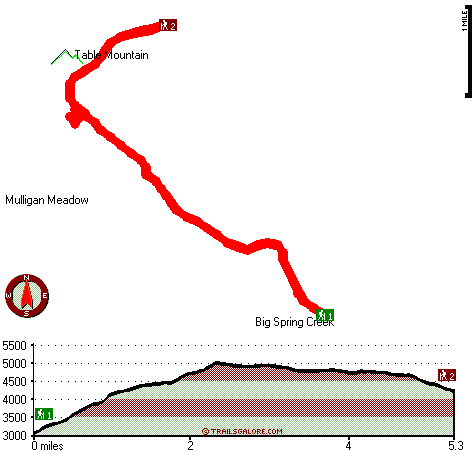
The total elevation difference for Table Mountain Trail is 2,007 feet which is about average. Some parts of this great outdoors trail are much higher up than other parts of the great outdoors trail, and that means that some parts of the great outdoors trail could be very different from other parts of it. This is a long great outdoors trail, so don't forget to pack enough supplies. This trail has two trailheads, so if you can get a ride from someone, you can backcountry trek it just one way. With its 10.6 miles of walking distance; it's longer than many great outdoors trails. Now, this is roughly a 1.5-day backcountry trek, so it's a good thing if your backpack is big enough to do the job.
|
Trailhead 1 to Trailhead 2:
Total hiking length = 5.3 miles
Total climbing distance = 2.6 miles
Difficulty : Medium
Casual Hiking Pace:
5 hours
Fast Hiking Pace:
2.5 hours
Trailhead 2 to Trailhead 1:
Total hiking length = 5.3 miles
Total climbing distance = 1.9 miles
Difficulty : Medium
Casual Hiking Pace:
4.5 hours
Fast Hiking Pace:
2.5 hours
| | Trailhead 1 back to Trailhead 1:
Total hiking length = 10.6 miles
Total climbing distance = 4.5 miles
Difficulty : Difficult
Casual Hiking Pace:
1.5 days
Fast Hiking Pace:
6 hours
Trailhead 2 back to Trailhead 2:
Total hiking length = 10.6 miles
Total climbing distance = 4.5 miles
Difficulty : Difficult
Casual Hiking Pace:
1.5 days
Fast Hiking Pace:
6 hours
|
Total elevation difference: 2007 feet
|


