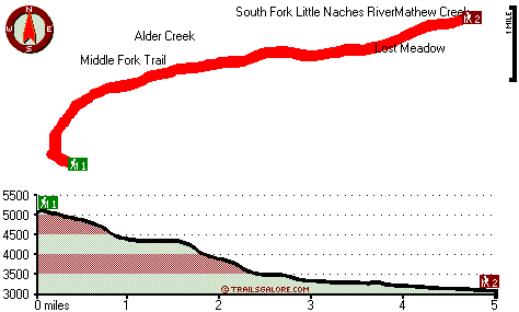
| |
|
| | South Fork Trail is a backcountry trail pretty far from Ellensburg, but when you trek it you're always having a perfect time. Every single Washington hiking and backpacking trail has something unique to offer. In Washington you never run out of outdoors fun. Hiking trails are tremendous and plentiful in Washington, and one of those is South Fork Trail in Yakima County. There are so many hiking trails in this vicinity. Put on your hiking shoes, and hit the backcountry trail, South Fork Trail in Yakima County, Washington is a perfect site for getting |
|
out. Please follow all local rules about fires and camping. During the long summer days highs here at South Fork Trail reach the 70's, and throughout summer nights temperatures are in the 40's. Through the winter highs are in the 30's with temperatures at South Fork Trail dipping
| | down into the 20's throughout winter nights. This is a two-ended trail with two trailheads which means you have the option of backcountry backpacking it one way if you have someone to pick you up at the other end. Trails like this one here in the Northern Cascade Range are the best way to enjoy these mountains. The length of South Fork Trail is on the longer side having an average number of uphill miles which makes this a very tough hiking trail for advanced trekkers looking for a tremendous challenge. South Fork Trail has a total elevation difference | |
|
of 2,365 feet which is about average. With its 10 miles of walking distance; it's longer than many wilderness hiking trails. South Fork Trail is quite long, so make sure you bring plenty of supplies. Different parts of this wilderness hiking trail are at very different elevations,
and that means that some parts of the wilderness hiking trail could be very different from other parts of it. The time needed for this backcountry walk is roughly 8.5 hours, but you never know stuff could go wrong and you could get stuck so be prepared for that. Here in the tremendous
state of Washington backcountry hiking is so much fun. All the water falling down from the sky makes South Fork Trail a wet spot; the month with most of the rain is January, and July is the month with the least moisture.
Briefly about the general area: If you have a
thing about the outdoors, you'll adore South Fork Trail. Take a little visit to Alder Creek while you're here at South Fork Trail, and American River has a good whitewater paddling spot nearby. These mountains rock, just explore all the cool stuff to do in the Northern Cascade
Range. Fawn Creek is right next door to South Fork Trail and is always a pleasure to have a look at; if you came for an overnight stay Pine Needle Campground is a good place to camp. This is a really good river. Do set aside some time for Timothy Meadow if you're here at South
Fork Trail, and whitewater paddling is perfect on Bumping River. While you're here at South Fork Trail it's a magnificent idea to have a look at Mathew Meadow, and why not camp at Hells Crossing Campground since you're here at South Fork Trail.
|
|
Location of Trailhead 1: Latitude 47.0355, Longitude -121.2924 - - Directions and Road Map
Location of Trailhead 2: Latitude 47.0634, Longitude -121.2174 - - Directions and Road Map

Trailhead 1 to Trailhead 2: Total hiking length = 5 miles Total climbing distance = .1 miles Difficulty : Easy Casual Hiking Pace:
3 hours
Fast Hiking Pace:
1.5 hours
Trailhead 2 to Trailhead 1: Total hiking length = 5 miles Total climbing distance = 3.3 miles Difficulty : Medium Casual Hiking Pace:
5 hours
Fast Hiking Pace:
3 hours
| | Trailhead 1 back to Trailhead 1: Total hiking length = 10 miles Total climbing distance = 3.4 miles Difficulty : Difficult Casual Hiking Pace:
8.5 hours
Fast Hiking Pace:
5 hours
Trailhead 2 back to Trailhead 2: Total hiking length = 10 miles Total climbing distance = 3.4 miles Difficulty : Difficult Casual Hiking Pace:
8.5 hours
Fast Hiking Pace:
5 hours
|
Total elevation difference: 2365 feet

Suncadia Resort, Cle Elum
|
19 miles away
Set on the sunny eastern slopes of the Cascades alongside the sparkling waters of the Cle Elum River and surrounded by pristine pine forest-Suncadia offers the ultimate luxury mountain resort experien...
|
| |
Stewart Lodge, Cle Elum
|
22 miles away
The Stewart Lodge offers a wide range of rooms and amenities to make us your recreational or business spot all year around. Our rooms are exceptionally large and include unique pine furniture, microw...
|
|
User input for South Fork Trail, Northern Cascade Range, Yakima County, Washington:

Outdoors Recreation Near Ellensburg, Washington Very comprehensive list of a variety of outdoors recreation in the vicinity of Ellensburg, Washington, the metro area neareast to South Fork Trail. Find info on campgrounds, hiking trails, ski resorts, lakes, beaches, parks, whitewater and more.
|
Current weather conditions at South Fork Trail, Northern Cascade Range, Yakima County, Washington

Local climate location: GREENWATER 8 miles away

           
| |
Best Western Snowcap Lodge, Cle Elum
|
22 miles away
The contemporary Best Western Snowcap Lodge is centrally located on the eastern slopes of the cascade mountains. We are easily accessible from Interstate 90, just a short 90 minute drive from Seattle....
|
Cle Elum Travelers Inn, Cle Elum
|
24 miles away
Located in western Washington and a short distance to I-90, the Cle Elum Travelers Inn is conveniently located to golfing, shopping, Summit at Snoqualmie, Ellensburg, Iron Horse State Park, Cle Elum L...
|
|
More Hotels and Campgrounds Near South Fork Trail, Northern Cascade Range, Yakima County, Washington
| |
| |
 |
|
| These outdoors activities are available near South Fork Trail. |
| | Trails Near South Fork Trail:
 |
Middle Fork Trail, Yakima County
County
, 2 miles away, 7.2 hiking miles, 3118 feet elevation difference |
 |
Bear Creek Trail, Kittitas County
County
, 4 miles away, 2 hiking miles, 1374 feet elevation difference |
 |
Fifes Ridge Trail, Yakima County
County
, 4 miles away, 13 hiking miles, 4581 feet elevation difference |
 |
Granite Creek Trail, Kittitas County
County
, 4 miles away, 18 hiking miles, 1280 feet elevation difference |
 |
Mount Cliffty Trail, Kittitas County
County
, 5 miles away, 9.8 hiking miles, 3795 feet elevation difference |
 |
Big Creek Trail, Kittitas County
County
, 6 miles away, 8.1 hiking miles, 1866 feet elevation difference |
 |
Goat Creek Trail, Yakima County
County
, 6 miles away, 8 hiking miles, 3879 feet elevation difference |
|
| | Whitewater Near South Fork Trail:
 |
American River, Yakima County
County
, 5 miles away, Class III-IV - 4.7 miles long (Hell's Crossing to American Forks) |
 |
Bumping River, Yakima County
County
, 6 miles away, Class II - 10.5 miles long (Bumping Reservoir to American River) |
 |
American River, -blank- County
County
, 7 miles away, Class II-III+ - 7.5 miles long (Lodgepole Campground to Hell's Crossing) |
 |
Little Naches River, Yakima/Kittitas County
County
, 7 miles away, Class II-III+(IV) - 9.5 miles long (Matthew Creek to Little Naches Campground) |
 |
American River, Yakima County
County
, 9 miles away, Class II+ - 5 miles long (American Forks to Sawmill Flat) |
|
| | Hotels Near South Fork Trail:
 |
Crystal Mountain Hotels, Enumclaw
, 16 miles away |
 |
Roslyn Inns, Roslyn
, 18 miles away |
 |
Suncadia Resort, Cle Elum
, 19 miles away |
 |
Best Western Inn, Snoqualmie Pass
, 20 miles away |
 |
Stewart Lodge, Cle Elum
, 22 miles away |
|
|
|
 |
|