Washington hiking trails - Sand Ridge Trail, Northern Cascade Range, Yakima County

   
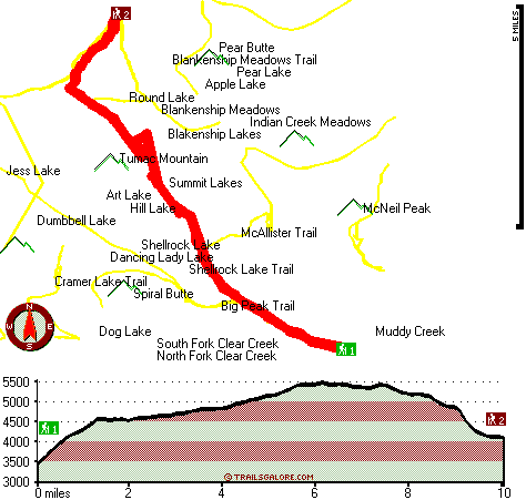
  The hike started out on the dry sandy rocky trail and with a slight grade up. After the 0.75 of a mile and 300 foot gain or so there was a fork; shortly after the you're ?entering the wilderness? sign, trail 1147, or Little Buck Trail is to the right. We haven't been on it, but it is suppose to be about a 0.9 of a mile and end up at the Indian Creek Trailhead and campground. After that fork Sand Ridge Trail, 1104, goes up for about 1 mile, and the foot gain for that mile is about 900 feet. According to the maps and the GPS we were using, the trail begins
    at about 3400 feet and goes to about 4600 feet. The last mile is like a standard up and down hike until the Shellrock Lake Trail junction, trail 1142 to the left, after that we don't know. Overall, for about the first 2 miles there is a 1200 foot gain in elevation, and then it
evens out for a while. However, we had to turn around when we thought we were almost to the Shellrock Lake Trail junction due to a couple feet of snow pack and melt off. Says Stephanie

Backpacking in Washington never gets boring. A long drive separates Ellensburg from Sand Ridge Trail, but it is an excellent hideaway from the settlement. Hey, time for a backcountry walk don’t you think? Sand Ridge Trail in Yakima County, Washington is just the place. Different parts of Sand Ridge Trail are at very different elevations, so keep in mind that you may
 
need to dress differently at different elevations. Of course, this is an overnight backcountry trek, 3 days normally, so make sure you've got all your overnight gear packed. This is one of many trails in the surrounding area. Much rainfall falls at Sand Ridge Trail; January is the month that gets the most snow, and the driest month of the year is July. These backcountry trails here in the Northern Cascade Range are a brilliant way to explore these mountaintops. Sand Ridge Trail is 20 miles long; it's longer than many wilderness trails. Each one of the many backcountry trails of Washington has its own unique prettiness. Don’t forget to check for any current restrictions or closures before you go. If you are in Washington during backpacking season you have to go backpacking. Sand Ridge Trail is a backcountry trail of glorious length having an average number of uphill miles which makes it an excellent trail for experienced trekkers in good shape. Sand Ridge Trail is quite long, so don't forget to pack enough supplies. Backcountry hiking trails for backpacking, and backpacking can be found all over Washington, and Sand Ridge Trail is one of them, and it's in Yakima County. This is a two-ended great outdoors trail with two trailheads, so if you can get a ride from someone, you can backcountry trek it just one way. At Sand Ridge Trail throughout the warm months highs are in the 60's. During the dark hours of summer temperatures drop down into the 40's. During the winter highs are in the 30's; nighttime lows at Sand Ridge Trail all through the wintertime frequently drop into the 10's. Sand Ridge Trail has a total elevation difference of 2,174 feet which is about average.

Briefly about the general area:
North Fork Clear Creek is a splendid local stream; you can run the rapids of American River. You clearly have to fancy the Northern Cascade Range. A pleasant spree to Indian Creek Meadows is a glorious way to spend an afternoon, and Cortright Point is very near and is a delightful location to explore. These mountains rock, just check out all the exciting things to do in the Northern Cascade Range. There's a forest here at Sand Ridge Trail called Gifford Pinchot National Forest; Hidden Spring is always fun to check out.
Take a side trip to South Fork Clear Creek, and a fine site to have a look at nearby is Mosquito Valley. White Pass Campground is a glorious campground nearby; Tieton River - South Fork is a delightful whitewater spot nearby. Blankenship Meadows is a magnificent site to stretch your legs a bit.
Having a delightful time at Sand Ridge Trail is painless. Stay the night at Bumping Lake - Wenatchee National Forest, and do put some time aside to spend at Indian Spring since you're here at Sand Ridge Trail.

Location of Trailhead 1: Latitude 46.6523, Longitude -121.2771
- - Directions and Road Map

Location of Trailhead 2: Latitude 46.7608, Longitude -121.3499
- - Directions and Road Map


Trailhead 1 to Trailhead 2:
Total hiking length = 10 miles
Total climbing distance = 5.2 miles
Difficulty : Difficult
Casual Hiking Pace: 1.5 days
Fast Hiking Pace: 5.5 hours

Trailhead 2 to Trailhead 1:
Total hiking length = 10 miles
Total climbing distance = 3.4 miles
Difficulty : Difficult
Casual Hiking Pace: 8.5 hours
Fast Hiking Pace: 4.5 hours
    Trailhead 1 back to Trailhead 1:
Total hiking length = 20 miles
Total climbing distance = 8.6 miles
Difficulty : Difficult
Casual Hiking Pace: 3 days
Fast Hiking Pace: 2 days

Trailhead 2 back to Trailhead 2:
Total hiking length = 20 miles
Total climbing distance = 8.6 miles
Difficulty : Difficult
Casual Hiking Pace: 3 days
Fast Hiking Pace: 2 days

Total elevation difference: 2174 feet


Suncadia Resort, Cle Elum
33 miles away
Set on the sunny eastern slopes of the Cascades alongside the sparkling waters of the Cle Elum River and surrounded by pristine pine forest-Suncadia offers the ultimate luxury mountain resort experien...
  
Howard Johnson Snoqualmie/Summit, Snoqualmie Pass
34 miles away
On Snoqualmie Pass, The only hotel on the mountain, Outdoor Heated Swimming pool, Indoor Hot Tub and Sauna. Ski across the street - 4 mountains to ski from. Free Shuttle Service to all Base Areas at ...
User input for Sand Ridge Trail, Northern Cascade Range, Yakima County, Washington:

Submit Input:
Your Name:
Write or Paste Input here:

Upload picture:      Review Guidelines


Outdoors Recreation Near Yakima, Washington
Very comprehensive list of a variety of outdoors recreation in the vicinity of Yakima, Washington, the metro area neareast to Sand Ridge Trail. Find info on campgrounds, hiking trails, ski resorts, lakes, beaches, parks, whitewater and more.

Current weather conditions at Sand Ridge Trail, Northern Cascade Range, Yakima County, Washington
WXPort

Local climate location: RAINIER PARADISE R S 13 miles away

Stewart Lodge, Cle Elum
35 miles away
Carat Hotel Dusseldorf GmbH offers a wide range of rooms and amenities to make us your recreational or business spot all year around. Our rooms are exceptionally large and include unique pine furnitu...

Best Western Snowcap Lodge, Cle Elum
35 miles away
Discover this Cle Elum, Washington hotel offering warm and comfortable accommodations near the Cascade Mountains. Welcome to the Best Western Snowcap Lodge where the service is friendly, the amenit...

More Hotels and Campgrounds Near Sand Ridge Trail, Northern Cascade Range, Yakima County, Washington

OTHER_INFO
  Northern Cascade Range Campgrounds
Complete list of all the campgrounds in the Northern Cascade Range.

Northern Cascade Range Outdoors Info
Complete outdoors info for the Northern Cascade Range.

Washington Hiking Trails
Complete list of all hiking trails in Washington

Books about hiking trails in Washington
List of books available on Amazon.com about hiking trails in Washington.

Washington Outdoors Index
This is a very comprehensive index of outdoors activities in the great state of Washington.


TOPO
High quality water resistant topo map of Sand Ridge Trail, Northern Cascade Range, Yakima County, Washington.

OUTDOORS_GUIDE
These outdoors activities are available near Sand Ridge Trail.
 Trails Near Sand Ridge Trail:
McAllister Trail, Yakima County County , 1 miles away,  4.2 hiking miles, 686 feet elevation difference
Shellrock Lake Trail, Yakima County County , 1 miles away,  13.8 hiking miles, 2067 feet elevation difference
Blankenship Meadows Trail, Yakima County County , 2 miles away,  7.4 hiking miles, 1367 feet elevation difference
Big Peak Trail, Yakima County County , 2 miles away,  11 hiking miles, 2631 feet elevation difference
Indian Creek Trail, Lewis County County , 3 miles away,  6.8 hiking miles, 1528 feet elevation difference
Pear Butte Trail, Yakima County County , 3 miles away,  13.2 hiking miles, 2981 feet elevation difference
Hogback Trail, Yakima County County , 4 miles away, 7.7 hiking miles, 2654 feet elevation difference
 Camp Grounds Near Sand Ridge Trail:
White Pass Campground, Yakima County, 5 miles away
Bumping Lake - Wenatchee National Forest, Chelan, 7 miles away
Knuppenburg Lake Campground, Lewis County, 7 miles away
Boat Landing Campground, Yakima County, 8 miles away
Bumping Dam Campground, Yakima County, 8 miles away
 Whitewater Near Sand Ridge Trail:
American River, -blank- County County , 11 miles away, Class II-III+ - 7.5 miles long (Lodgepole Campground to Hell's Crossing)
Tieton River - South Fork, Yakima County County , 11 miles away, Class IV(V+) - 5.7 miles long (Grey Creek Campground to Rimrock Lake)
Bumping River, Yakima County County , 12 miles away, Class II - 10.5 miles long (Bumping Reservoir to American River)
Summit Creek, Lewis County County , 14 miles away, Class V+ - 5 miles long (Soda Springs to Highway 123)
American River, Yakima County County , 15 miles away, Class III-IV - 4.7 miles long (Hell's Crossing to American Forks)
 National Parks Near Sand Ridge Trail:
Mount Rainier National Park, Ashford - WA , 45 miles away
 Hotels Near Sand Ridge Trail:
Suncadia Resort, Cle Elum , 33 miles away
Howard Johnson Snoqualmie/Summit, Snoqualmie Pass , 34 miles away
Stewart Lodge, Cle Elum , 35 miles away
Best Western Snowcap Lodge, Cle Elum , 35 miles away
Best Western Hood River Inn, Hood River , 49 miles away
 Lakes Near Sand Ridge Trail
Dog Lake, Yakima County , 3 miles away
Dumbbell Lake, Lewis County , 4 miles away

Outdoors related information copyright © Stratus-Pikpuk, Inc. - Detailed hotel information copyright © Interactive Hotel Solutions