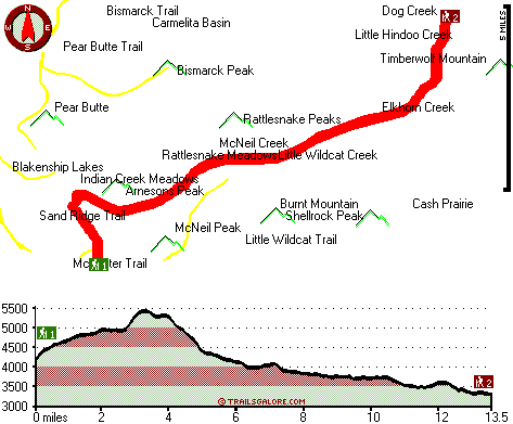
Washington hiking trails - Rattlesnake Trail, Northern Cascade Range, Yakima County

   
  When you're here in Washington backcountry trekking along one of its wilderness hiking trails never gets boring. In Washington you never run out of outdoors fun. We all need to get out in nature once in a while, and Rattlesnake Trail in Yakima County, Washington is just the place. This is a long backpacking trail, so make sure you bring plenty of supplies. Don’t forget to check for any current restrictions or closures before you go. This backpacking and hiking trail is a backpacking and hiking trail of wonderful length having an average number of uphill
    miles which makes it an outstanding hiking trail for experienced backcountry trekkers in good shape. At Rattlesnake Trail through the summer months highs are in the 60's while night lows are usually in the 40's. All through the winter highs are usually in the 30's with winter lows
in the 10's overnight here at Rattlesnake Trail. The picturesque backpacking and hiking trails of the Northern Cascade Range are the best way to enjoy these mountains. This is just one of a large number of hiking trails in this vicinity. Rattlesnake Trail is a two ended great outdoors hiking trail with two trailheads which means you have the option of backcountry hiking it one way if you have someone to pick you up at the other end. Every single Washington wilderness hiking trail is well worth a hike. Backcountry hiking trails are great and plentiful in Washington,  
and Rattlesnake Trail in Yakima County is one of them. Rattlesnake Trail is 27 miles long; it's considered a longer backcountry hike. Rattlesnake Trail is not very near Ellensburg at all, but there's great natural loveliness waiting for you here along it. The total elevation difference for Rattlesnake Trail is 2,679 feet which is higher than average. Some parts of this backcountry trail are much higher up than other parts of the backcountry trail, so keep in mind that you may need to dress differently at different elevations. Rattlesnake Trail sees pretty high levels of rain; January is when you get the most snow here; the driest month is July. This hike should take you about 4 days, so it's a great thing if your backpack is big enough to do the job.

Briefly about the general area:
The surroundings of this river have so much to offer. Just can't get enough of Rattlesnake Trail. Twelve West Resort is a perfect campground here, and some of the water close by flows, like McNeil Creek.
There's no way anyone can get bored here in the Northern Cascade Range. A fine place to check out in the vicinity of Rattlesnake Trail is Mosquito Valley, and a tour to Rattlesnake Meadows rejuvenates the soul. So many fun things to do in the Northern Cascade Range, not enough time. Get yourself into a kayak and hit Bumping River, and camping at Rattlesnake Trail is great fun, Rimrock Public Campground and Boat Landing is a great local campground. This river has so much to offer. Soar down the rapids of Tieton River - South Fork in a kayak, and Indian Spring is an inspiring place to pop by while you're here.
Silver Salmon Cove is quite in the vicinity of Rattlesnake Trail, and the beauty of mother nature reveals herself at Clover Spring. Looking for some flowing water? Try Little Wildcat Creek; Strawberry Meadows is right here at Rattlesnake Trail.

Location of Trailhead 1: Latitude 46.6899, Longitude -121.3008
- - Directions and Road Map

Location of Trailhead 2: Latitude 46.7857, Longitude -121.1651
- - Directions and Road Map


Trailhead 1 to Trailhead 2:
Total hiking length = 13.5 miles
Total climbing distance = 5.1 miles
Difficulty : Difficult
Casual Hiking Pace: 2 days
Fast Hiking Pace: 6.5 hours

Trailhead 2 to Trailhead 1:
Total hiking length = 13.5 miles
Total climbing distance = 6.7 miles
Difficulty : Difficult
Casual Hiking Pace: 2 days
Fast Hiking Pace: 7 hours
    Trailhead 1 back to Trailhead 1:
Total hiking length = 27 miles
Total climbing distance = 11.8 miles
Difficulty : Difficult
Casual Hiking Pace: 4 days
Fast Hiking Pace: 2.5 days

Trailhead 2 back to Trailhead 2:
Total hiking length = 27 miles
Total climbing distance = 11.8 miles
Difficulty : Difficult
Casual Hiking Pace: 4 days
Fast Hiking Pace: 2.5 days

Total elevation difference: 2679 feet


Suncadia Resort, Cle Elum
28 miles away
Set on the sunny eastern slopes of the Cascades alongside the sparkling waters of the Cle Elum River and surrounded by pristine pine forest-Suncadia offers the ultimate luxury mountain resort experien...
  
Stewart Lodge, Cle Elum
29 miles away
The Stewart Lodge offers a wide range of rooms and amenities to make us your recreational or business spot all year around. Our rooms are exceptionally large and include unique pine furniture, microw...
User input for Rattlesnake Trail, Northern Cascade Range, Yakima County, Washington:

Submit Input:
Your Name:
Write or Paste Input here:

Upload picture:      Review Guidelines


Outdoors Recreation Near Ellensburg, Washington
Very comprehensive list of a variety of outdoors recreation in the vicinity of Ellensburg, Washington, the metro area neareast to Rattlesnake Trail. Find info on campgrounds, hiking trails, ski resorts, lakes, beaches, parks, whitewater and more.

Current weather conditions at Rattlesnake Trail, Northern Cascade Range, Yakima County, Washington
WXPort

Local climate location: RAINIER PARADISE R S 18 miles away

Best Western Snowcap Lodge, Cle Elum
30 miles away
The contemporary Best Western Snowcap Lodge is centrally located on the eastern slopes of the cascade mountains. We are easily accessible from Interstate 90, just a short 90 minute drive from Seattle....

Cle Elum Travelers Inn, Cle Elum
31 miles away
Located in western Washington and a short distance to I-90, the Cle Elum Travelers Inn is conveniently located to golfing, shopping, Summit at Snoqualmie, Ellensburg, Iron Horse State Park, Cle Elum L...

More Hotels and Campgrounds Near Rattlesnake Trail, Northern Cascade Range, Yakima County, Washington

OTHER_INFO
  Northern Cascade Range Campgrounds
Complete list of all the campgrounds in the Northern Cascade Range.

Northern Cascade Range Outdoors Info
Complete outdoors info for the Northern Cascade Range.

Washington Hiking Trails
Complete list of all hiking trails in Washington

Books about hiking trails in Washington
List of books available on Amazon.com about hiking trails in Washington.

Washington Outdoors Index
This is a very comprehensive index of outdoors activities in the great state of Washington.


TOPO
High quality water resistant topo map of Rattlesnake Trail, Northern Cascade Range, Yakima County, Washington.

OUTDOORS_GUIDE
These outdoors activities are available near Rattlesnake Trail.
 Trails Near Rattlesnake Trail:
Little Wildcat Trail, Yakima County County , 2 miles away,  13.6 hiking miles, 1780 feet elevation difference
Ironstone Mountain Trail, Yakima County County , 3 miles away,  7.6 hiking miles, 2130 feet elevation difference
Bismarck Trail, Yakima County County , 5 miles away,  14.2 hiking miles, 4496 feet elevation difference
Pear Butte Trail, Yakima County County , 5 miles away,  13.2 hiking miles, 2981 feet elevation difference
McAllister Trail, Yakima County County , 5 miles away,  4.2 hiking miles, 686 feet elevation difference
Richmond Mine Trail, Yakima County County , 6 miles away,  10 hiking miles, 3203 feet elevation difference
Sand Ridge Trail, Yakima County County , 6 miles away, 10 hiking miles, 2174 feet elevation difference
 Camp Grounds Near Rattlesnake Trail:
Rimrock Public Campground and Boat Landing, Yakima County, 5 miles away
Twelve West Resort, Naches, 6 miles away
Bumping Lake - Wenatchee National Forest, Chelan, 7 miles away
Boat Landing Campground, Yakima County, 7 miles away
Grey Creek Campground, Yakima County, 7 miles away
 Whitewater Near Rattlesnake Trail:
Tieton River - South Fork, Yakima County County , 8 miles away, Class IV(V+) - 5.7 miles long (Grey Creek Campground to Rimrock Lake)
Bumping River, Yakima County County , 9 miles away, Class II - 10.5 miles long (Bumping Reservoir to American River)
American River, Yakima County County , 11 miles away, Class III-IV - 4.7 miles long (Hell's Crossing to American Forks)
American River, -blank- County County , 11 miles away, Class II-III+ - 7.5 miles long (Lodgepole Campground to Hell's Crossing)
American River, Yakima County County , 14 miles away, Class II+ - 5 miles long (American Forks to Sawmill Flat)
 National Parks Near Rattlesnake Trail:
Mount Rainier National Park, Ashford - WA , 51 miles away
 Hotels Near Rattlesnake Trail:
Game Ridge Motel, Naches , 18 miles away
Crystal Mountain Hotels, Enumclaw , 19 miles away
Suncadia Resort, Cle Elum , 28 miles away
Roslyn Inns, Roslyn , 29 miles away
Stewart Lodge, Cle Elum , 29 miles away
 Lakes Near Rattlesnake Trail
Pear Lake, Yakima County , 5 miles away
Richmond Lake, Yakima County , 5 miles away

Outdoors related information copyright © Stratus-Pikpuk, Inc. - Detailed hotel information copyright © Interactive Hotel Solutions