Washington hiking trails - Pompey Peak Trail, Northern Cascade Range, Lewis County

   
  Put on your backcountry hiking shoes, and hit the backcountry hiking trail, Pompey Peak Trail in Lewis County, Washington is a really tremendous place to spend some time. There are numerous backcountry trails in Washington, and each one is different from the others. If you happen to be in Washington, why not go backpacking, it is so much fun. This is one of many great outdoors hiking trails in the surrounding vicinity. Keep in mind that this is a long wilderness trail, so make sure you bring plenty of supplies. Pompey Peak Trail is a mid-length backcountry
    hiking trail having an average number of uphill miles which makes it a splendid great outdoors hiking trail for experienced backcountry trekkers in brilliant shape. For the period of the summertime months, highs commonly are in the 70's at Pompey Peak Trail. Summer night lows drop
down to the 40's. Throughout the wintertime this location gets highs in the 30's, and night lows all through the wintertime for Pompey Peak Trail tend to be in the 20's. This hike shouldn't take more than 6 hours, but of course some people walk a bit slower and some a bit faster. Wilderness trails like this one here in the Northern Cascade Range are a perfect way to explore these highlands. Glorious backcountry trails in Washington are in abundance, and Pompey Peak Trail in Lewis County is one of them. Pompey Peak Trail goes through some very different  
elevations which of course means you need to be prepared for different conditions on different parts of the hiking and backpacking trail. There is only one trailhead, so you'll be backcountry backpacking it in and back out. Being 7 miles long it's a mid length hike. Pompey Peak Trail is not very near Hood River at all, but It's always amusing to hike here. All the water falling down from the sky makes Pompey Peak Trail a wet location; December is when you get the most snow here while July is typically the driest month. Don’t forget to check for any current restrictions or closures before you go. Pompey Peak Trail has a total elevation difference of 3,836 feet which is higher than average. In Washington you never run out of outdoors fun.

Briefly about the general area:
You can run the rapids of Yellowjacket Creek close to Pompey Peak Trail, and a quick trip to Garrett Creek is definitely a good idea. Don't miss out on a trip to Mount Rainier National Park if you're here at Pompey Peak Trail; if you came to camp Naco West is a perfect place to do that.
A journey to Kilborn Spring will fill your spirit with tremendous feelings, and needless to say Burton Creek flows through this neighborhood. All the outdoors cool stuff in the Northern Cascade Range will keep you coming back repeatedly. Get your heart pumping on the good whitewater of Cispus River, and camping at Maple Leaf Campground is always a great experience. Yeah, come here to Pompey Peak Trail for a perfect time.

Location of Trailhead: Latitude 46.5198, Longitude -121.7955
- - Directions and Road Map

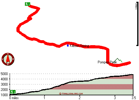
Total in and out hiking length = 7 miles

Total climbing distance = 2.8 miles

Difficulty : Difficult

Casual Hiking Pace: 6 hours

Fast Hiking Pace: 4 hours

Total elevation difference: 3836 feet


Kings Valu Inn, Enumclaw
35 miles away
Kings Valu Inn *Free Wireless Internet - Outdoor Seasonal Pool - In-Room Coffee - Quality Rooms* Kings Valu Inn is the complete home away from home for your traveling convenience. Stay for a day, a we...
  
Econo Lodge Buckley, Buckley
36 miles away
Mt. Rainier National Park, Puyallup Fairground, Crystal Mountain, White River Amphitheater and King County Fairground are all nearby. All rooms have microwaves, refrigerators, iron and ironing board. ...
User input for Pompey Peak Trail, Northern Cascade Range, Lewis County, Washington:

Submit Input:
Your Name:
Write or Paste Input here:

Upload picture:      Review Guidelines


Outdoors Recreation Near Hood River, Oregon
Very comprehensive list of a variety of outdoors recreation in the vicinity of Hood River, Oregon, the metro area neareast to Pompey Peak Trail. Find info on campgrounds, hiking trails, ski resorts, lakes, beaches, parks, whitewater and more.

Current weather conditions at Pompey Peak Trail, Northern Cascade Range, Lewis County, Washington
WXPort

Local climate location: LONGMIRE RAINIER NPS 20 miles away

Skamania Lodge, Stevenson
40 miles away
Skamania Lodge is located in the beautiful Columbia River Gorge just 45 minutes from Portland International Airport. Discover all the luxuries of this Pacific Northwest style resort, including 18-hole...

Best Western Columbia River Inn, Cascade Locks
41 miles away
Enjoy the spectacular scenery of the Columbia River Gorge at this Cascade Locks hotel. The Best Western Columbia River Inn is a fully non-smoking property located only 45 miles from Portland, Oregon ...

More Hotels and Campgrounds Near Pompey Peak Trail, Northern Cascade Range, Lewis County, Washington

OTHER_INFO
  Northern Cascade Range Campgrounds
Complete list of all the campgrounds in the Northern Cascade Range.

Northern Cascade Range Outdoors Info
Complete outdoors info for the Northern Cascade Range.

Washington Hiking Trails
Complete list of all hiking trails in Washington

Books about hiking trails in Washington
List of books available on Amazon.com about hiking trails in Washington.

Washington Outdoors Index
This is a very comprehensive index of outdoors activities in the great state of Washington.


TOPO
High quality water resistant topo map of Pompey Peak Trail, Northern Cascade Range, Lewis County, Washington.

OUTDOORS_GUIDE
These outdoors activities are available near Pompey Peak Trail.
 Trails Near Pompey Peak Trail:
Klickitat Trail, Lewis County County , 3 miles away,  4.2 hiking miles, 1263 feet elevation difference
Davis Mountain Trail, Lewis County County , 3 miles away, 6.7 hiking miles, 3121 feet elevation difference
Willame Trail, Lewis County County , 4 miles away, 3.5 hiking miles, 921 feet elevation difference
Purcell Mountain Trail, Lewis County County , 5 miles away, 8.5 hiking miles, 5050 feet elevation difference
Dry Creek Trail, Lewis County County , 5 miles away, 6.4 hiking miles, 5447 feet elevation difference
 Camp Grounds Near Pompey Peak Trail:
Naco West, Randle, 1 miles away
Maple Leaf Campground, Lewis County, 3 miles away
Atkisson - Gifford Pinchot National Forest, Randle, 8 miles away
Beaver Campground - Gifford Pinchot National Forest, Randle, 8 miles away
Big Creek - Gifford Pinchot National Forest, Randle, 8 miles away
 Whitewater Near Pompey Peak Trail:
Cispus River, Lewis County County , 5 miles away, Class III+(IV) - 9.5 miles long (FR 23 Bridge to FR 28 Bridge)
Yellowjacket Creek, Skamania/Lewis County County , 6 miles away, Class IV - 5.2 miles long (Veta Creek to Cispus River confluence)
Cispus River - North Fork, Lewis County County , 6 miles away, Class IV-V - 2.7 miles long (FR 22 Bridge to North Fork Campground)
Skate Creek, Lewis County County , 8 miles away, Class III+ - 3.1 miles long (Johnson Creek to Craig Road)
McCoy Creek, Lewis County County , 9 miles away, Class V - 7.8 miles long (milepost 8 to Yellowjacket Creek)
 National Parks Near Pompey Peak Trail:
Mount Rainier National Park, Ashford - WA , 18 miles away
 Hotels Near Pompey Peak Trail:
Kings Valu Inn, Enumclaw , 35 miles away
Econo Lodge Buckley, Buckley , 36 miles away
Skamania Lodge, Stevenson , 40 miles away
Best Western Columbia River Inn, Cascade Locks , 41 miles away
Comfort Suites Hood River, Hood River , 42 miles away
 Lakes Near Pompey Peak Trail
Lone Tree Lake, Lewis County , 4 miles away
Willame Lake, Lewis County , 4 miles away

Outdoors related information copyright © Stratus-Pikpuk, Inc. - Detailed hotel information copyright © Interactive Hotel Solutions