Washington hiking trails - Panther Creek Trail, Northern Cascade Range, Whatcom County

   
  Washington has plenty of great hiking and backpacking trails; among these are Panther Creek Trail in Whatcom County. Washington has so much to offer nature lovers. Every hiking and backpacking trail in Washington is worth backpacking. Panther Creek Trail is 17.4 miles long; it's considered a longer backcountry trek. Panther Creek Trail is a backcountry hiking trail of splendid length having an average number of uphill miles which makes this a very tough backpacking trail for advanced hikers looking for a tremendous challenge. There are so many backpacking
    trails in this area. When you're here in Washington backpacking along one of its hiking and backpacking trails is a splendid way to spend some time. Some parts of Panther Creek Trail are much higher up than other parts of the hiking trail, so keep in mind that you may need to dress
differently at different elevations. Keep in mind that this is a long trail, so do pack enough food to last the whole trip. The warmest time of the year at Panther Creek Trail comes with high temperatures in the 70's, and during summer nights temperatures are in the 50's. Highs during the wintertime are generally in the 30's, and after the sun is down during the wintertime temperatures at Panther Creek Trail dip into the 20's. The backcountry hiking trails of the Northern Cascade Range are a glorious way to explore these summits. The total elevation difference  
for this backpacking and hiking trail is 2,363 feet which is an average number. Can’t wait to get out in the fresh air, Panther Creek Trail in Whatcom County, Washington is a really magnificent place to spend some time. Please follow all local rules about fires and camping. Panther Creek Trail has two trailheads, so backcountry backpacking it one way is an option if you can arrange for a ride back. Panther Creek Trail sees pretty high levels of rain; November is when you get the most rain here, and the driest month of the year is July. Of course, this is an overnight backcountry walk, 2.5 days normally, so better have big backpack to fit all the stuff you need. Panther Creek Trail is very far from the most adjacent full-scale town, and if you're looking for a glorious place to go backcountry backpacking, this is a glorious choice.

Briefly about the general area:
So many cool things in the Northern Cascade Range, just inspiring. You can run the rapids of Stetattle Creek in the neighborhood of Panther Creek Trail, and needless to say Hidden Hand Creek flows through this region. Butler Brown Flats is a perfect place, and a quick tour to Lillian Creek is definitely a great idea.
There's whitewater on Granite Creek for all you thrill seekers; camping at Colonial Creek Campground is always a great experience. And that's not all the things you can do here in the Northern Cascade Range. That right there is heaps already, but it keeps on going; Panther Creek Trail has it all. Fourth of July Pass is a splendid location to pop by nearby; a journey to Panther Creek Trail wouldn't be complete without taking a look at John Pierce Waterfall.
Ruby Arm is near Panther Creek Trail and is a delightful site to explore, and Panther Creek Trail is great enough to spend more than a day at, Cougar Island Campground is a great local campground.

Location of Trailhead 1: Latitude 48.6857, Longitude -121.0924
- - Directions and Road Map

Location of Trailhead 2: Latitude 48.7064, Longitude -120.9719
- - Directions and Road Map


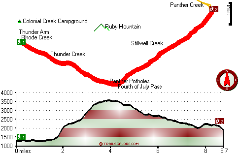
Trailhead 1 to Trailhead 2:
Total hiking length = 8.7 miles
Total climbing distance = 3.7 miles
Difficulty : Difficult
Casual Hiking Pace: 7.5 hours
Fast Hiking Pace: 4.5 hours

Trailhead 2 to Trailhead 1:
Total hiking length = 8.7 miles
Total climbing distance = 4.1 miles
Difficulty : Difficult
Casual Hiking Pace: 8 hours
Fast Hiking Pace: 4.5 hours
    Trailhead 1 back to Trailhead 1:
Total hiking length = 17.4 miles
Total climbing distance = 7.8 miles
Difficulty : Difficult
Casual Hiking Pace: 2.5 days
Fast Hiking Pace: 1.5 days

Trailhead 2 back to Trailhead 2:
Total hiking length = 17.4 miles
Total climbing distance = 7.8 miles
Difficulty : Difficult
Casual Hiking Pace: 2.5 days
Fast Hiking Pace: 1.5 days

Total elevation difference: 2363 feet


User input for Panther Creek Trail, Northern Cascade Range, Whatcom County, Washington:

Submit Input:
Your Name:
Write or Paste Input here:

Upload picture:      Review Guidelines


Outdoors Recreation Near Wenatchee, Washington
Very comprehensive list of a variety of outdoors recreation in the vicinity of Wenatchee, Washington, the metro area neareast to Panther Creek Trail. Find info on campgrounds, hiking trails, ski resorts, lakes, beaches, parks, whitewater and more.

Current weather conditions at Panther Creek Trail, Northern Cascade Range, Whatcom County, Washington
WXPort

Local climate location: ROSS DAM 11 miles away


More Hotels and Campgrounds Near Panther Creek Trail, Northern Cascade Range, Whatcom County, Washington

OTHER_INFO
  Northern Cascade Range Campgrounds
Complete list of all the campgrounds in the Northern Cascade Range.

Northern Cascade Range Outdoors Info
Complete outdoors info for the Northern Cascade Range.

Washington Hiking Trails
Complete list of all hiking trails in Washington

Books about hiking trails in Washington
List of books available on Amazon.com about hiking trails in Washington.

Washington Outdoors Index
This is a very comprehensive index of outdoors activities in the great state of Washington.


TOPO
High quality water resistant topo map of Panther Creek Trail, Northern Cascade Range, Whatcom County, Washington.

OUTDOORS_GUIDE
These outdoors activities are available near Panther Creek Trail.
 Trails Near Panther Creek Trail:
Jack Mountain Trail, Whatcom County County , 3 miles away,  9.4 hiking miles, 4860 feet elevation difference
Sourdough Lookout Trail, Whatcom County County , 5 miles away,  16.4 hiking miles, 5982 feet elevation difference
East Bank Trail, Whatcom County County , 5 miles away,  30 hiking miles, 1028 feet elevation difference
Pyramid Lake Trail, Whatcom County County , 7 miles away,  2.2 hiking miles, 1153 feet elevation difference
Park Creek Trail, Chelan County County , 12 miles away,  13 hiking miles, 4110 feet elevation difference
Mill Creek Trail, Whatcom County County , 14 miles away,  29.4 hiking miles, 5463 feet elevation difference
Hidden Lake Trail, Skagit County County , 14 miles away,  5.8 hiking miles, 2693 feet elevation difference
 Camp Grounds Near Panther Creek Trail:
Cougar Island Campground, Whatcom County, 3 miles away
Colonial Creek Campground, Whatcom County, 4 miles away
Big Bear Campground, Whatcom County, 5 miles away
Rainbow Point Campground, Whatcom County, 5 miles away
Tenmile Island Campground, Whatcom County, 8 miles away
 Whitewater Near Panther Creek Trail:
Granite Creek, Whatcom County County , 7 miles away, Class IV - 5 miles long (Beebe Creek to Panther Creek)
Stetattle Creek, Whatcom County County , 10 miles away, Class IV(V) - 4 miles long (Jay Creek to Gorge Lake)
Granite Creek, Skagit/whatcom County County , 12 miles away, Class IV-V(V+) - 4.6 miles long (Highway 20 to Beebe Creek)
Canyon Creek - Skagit Tributary, Whatcom County County , 13 miles away, Class IV-V - 6.7 miles long (Slate Creek to Granite Creek)
Cascade River, Skagit County County , 18 miles away, Class II - 6 miles long (Mineral Park to Marble Creek Campground)
 Lakes Near Panther Creek Trail
Ross Lake, Whatcom County , 3 miles away

Outdoors related information copyright © Stratus-Pikpuk, Inc. - Detailed hotel information copyright © Interactive Hotel Solutions