Washington hiking trails - Packer Trail, Blue Mountains, Garfield County

   
  Packer Trail is a great outdoors hiking trail rather far from La Grande, but trekking along this great outdoors hiking trail is very amusing. Washington is a good place for trekkers. Washington has plenty of tremendous backpacking and hiking trails, and Packer Trail is one of them, and it's in Garfield County. Some parts of Packer Trail are much higher up than other parts of the backcountry trail which of course means you need to be prepared for different conditions on different parts of the backcountry trail. Throughout the warmest time of the year
    highs here at Packer Trail reach the 80's. Summer overnight lows descend down to the 50's. Daytime highs throughout the wintertime are in the 40's, and overnight lows in the 20's for Packer Trail. This is a one trailhead backcountry hiking trail, so you'll be trekking it in and
back out. Every Washington backpacking and hiking trail is worth hiking. Please follow all local rules about fires and camping. With its 14.2 miles of walking distance; it's a long backcountry trail. Hiking here in Washington is something that is always fun to do. At parts of the year this area sees very little rain, so don’t forget to check for any current fire restrictions before you go. This backcountry hiking trail has a total elevation difference of 2,776 feet, and that is higher than average. When was the last time you got out in the great outdoors  
a bit? Packer Trail in Garfield County, Washington is a good spot to go. This great outdoors trail is a great outdoors trail of good length with an average amount of climbing distance which makes it an excellent hiking and backpacking trail for experienced backcountry walkers in fine shape. Packer Trail is ordinarily a quite arid site; the wettest month of the year is ordinarily January, that's the one that rains the most while July is ordinarily the driest month. This is a long wilderness trail, so don't forget to pack enough supplies. Hiking and backpacking trails like this one here in the Blue Mountains are a really good way to spend quality time in nature. There are so many hiking and backpacking trails in this neighborhood. This backcountry trek should take you about 2 days, so make sure you've got all your overnight gear packed.

Briefly about the general area:
Man, is there heaps of exciting stuff to do in the Blue Mountains. You can run the rapids of Grande Ronde River near Packer Trail; why not camp at Misery Spring Campground since you're here at Packer Trail. And that's not all you can do here at Packer Trail. Mud Spring is an inspiring place to stop at while you're here, and why not take a little journey to Melton Creek while you're here.
So many cool things to do here in the Blue Mountains, too wonderful to be true. A short journey to Pistol Spring is always worthwhile. There's whitewater on Grande Ronde River for all you adrenaline kick people, and Moore Flat is a splendid spot. Some close by water includes Cherry Creek, and a trip to Moore Flat invigorates the spirit.
Slide Canyon is a tremendous spot to stop at close by, and camping is available at Spruce Spring Campground.

Location of Trailhead: Latitude 46.0221, Longitude -117.5493
- - Directions and Road Map

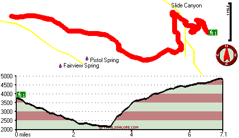
Total in and out hiking length = 14.2 miles

Total climbing distance = 6.2 miles

Difficulty : Difficult

Casual Hiking Pace: 2 days

Fast Hiking Pace: 8.5 hours

Total elevation difference: 2776 feet


Best Western Rama Inn & Suites, Enterprise
35 miles away
This full-service Enterprise, Oregon hotel is minutes away from local attractions and is an ideal weekend getaway from busy everyday life. Enjoy a peaceful and relaxing getaway to Northwestern Orego...
  
Best Western Rivertree Inn, Clarkston
41 miles away
Stay at this Clarkston hotel and experience an exceptional staff and comfortable accommodations near Washington State's key area attractions and business locations. Located at the Gateway to Hell's C...
User input for Packer Trail, Blue Mountains, Garfield County, Washington:

Submit Input:
Your Name:
Write or Paste Input here:

Upload picture:      Review Guidelines


Outdoors Recreation Near La Grande, Oregon
Very comprehensive list of a variety of outdoors recreation in the vicinity of La Grande, Oregon, the metro area neareast to Packer Trail. Find info on campgrounds, hiking trails, ski resorts, lakes, beaches, parks, whitewater and more.

Current weather conditions at Packer Trail, Blue Mountains, Garfield County, Washington
WXPort

Local climate location: POMEROY 19 miles away

Quality Inn & Suites Conference Center, Clarkston
42 miles away
The Quality Inn and Suites features a restaurant on premise with free full hot breakfast each morning for each registered adult. All rooms are newly renovated and come with a microwave, refrigerator, ...

Econo Lodge Lewiston, Lewiston
44 miles away
Short walking distance to downtown attractions and businesses. Several restaurants and shops also within walking distance. Central location with easy access to the Lewiston/Clarkson Valley. Pet accomm...

More Hotels and Campgrounds Near Packer Trail, Blue Mountains, Garfield County, Washington

OTHER_INFO
  Blue Mountains Campgrounds
Complete list of all the campgrounds in the Blue Mountains.

Blue Mountains Outdoors Info
Complete outdoors info for the Blue Mountains.

Washington Hiking Trails
Complete list of all hiking trails in Washington

Books about hiking trails in Washington
List of books available on Amazon.com about hiking trails in Washington.

Washington Outdoors Index
This is a very comprehensive index of outdoors activities in the great state of Washington.


TOPO
High quality water resistant topo map of Packer Trail, Blue Mountains, Garfield County, Washington.

OUTDOORS_GUIDE
These outdoors activities are available near Packer Trail.
 Trails Near Packer Trail:
Melton Creek Trail, Garfield County County , 4 miles away,  16.4 hiking miles, 4283 feet elevation difference
Smooth Ridge Trail, Columbia County County , 4 miles away,  36.8 hiking miles, 5156 feet elevation difference
Crooked Creek Trail, Garfield County County , 4 miles away, 21.4 hiking miles, 4731 feet elevation difference
Mount Misery Trail, Columbia County County , 6 miles away,  22.8 hiking miles, 969 feet elevation difference
Low Saddle Trail, Asotin County County , 6 miles away,  11.2 hiking miles, 1856 feet elevation difference
Bear Creek Trail, Garfield County County , 7 miles away, 8.3 hiking miles, 2461 feet elevation difference
July Ridge Trail, Garfield County County , 7 miles away,  5.4 hiking miles, 2063 feet elevation difference
 Camp Grounds Near Packer Trail:
Spruce Spring Campground, Garfield County, 8 miles away
Misery Spring Campground, Garfield County, 9 miles away
Tepee Campground, Columbia County, 10 miles away
Teepee Campground, Columbia County, 10 miles away
Big Spring Campground, Garfield County, 10 miles away
 Whitewater Near Packer Trail:
Grande Ronde River, Wallowa County County , 11 miles away, Class II-III - 46 miles long (Wallowa River to Grande Ronde River)
Grande Ronde River, Asotin County County , 16 miles away, Class II-III - 19.5 miles long (Troy to Boggan's Oasis)
Grande Ronde River, Union County County , 27 miles away, Class II-IV - 13 miles long (Elgin to Palmer Junction)
 Hotels Near Packer Trail:
Best Western Rama Inn & Suites, Enterprise , 35 miles away
Best Western Rivertree Inn, Clarkston , 41 miles away
Quality Inn & Suites Conference Center, Clarkston , 42 miles away
Econo Lodge Lewiston, Lewiston , 44 miles away
GuestHouse Inn & Suites Lewist, Lewiston , 44 miles away

Outdoors related information copyright © Stratus-Pikpuk, Inc. - Detailed hotel information copyright © Interactive Hotel Solutions