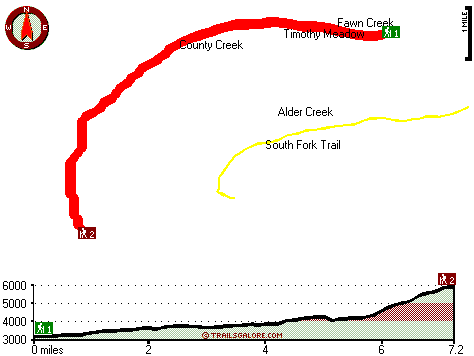
Washington hiking trails - Middle Fork Trail, Northern Cascade Range, Yakima County

   
  As long as you like the outdoors you will like Washington. Gotta get out of the settlement man, and Middle Fork Trail in Yakima County, Washington is just the location. Great great outdoors trails in Washington are in abundance, and among these are Middle Fork Trail in Yakima County. Don’t forget to check for any current restrictions or closures before you go. The backpacking trails of the Northern Cascade Range are the best way to enjoy these highlands. High temperatures at Middle Fork Trail during the warm months are in the 70's; the night is a tad
    chillier of course, commonly in the 40's. High temperatures all through the winter are normally in the 30's; all through the dark hours in the winter at Middle Fork Trail temperatures dip to the 20's. Each one of the many great outdoors trails of Washington has its own character.
The length of Middle Fork Trail is on the longer side with an average amount of climbing distance which makes this backcountry hiking trail good for hard core backpackers looking for adventure. Being 14.4 miles long; it's a long backpacking and hiking trail. A large amount of rainfall falls at Middle Fork Trail; the month with most of the rain is January while July is ordinarily the driest month. Now, this is roughly a 2-day trek, so it's a glorious thing if your backpack is big enough to do the job. If you happen to be in Washington, why not go trekking, it  
is a splendid idea. Middle Fork Trail has a total elevation difference of 3,118 feet, and that is higher than average. This is a long backcountry hiking trail, so do pack enough food to last the whole trip. There are two trailheads to chose from, one in each end which means you have the option of backcountry hiking it one way if you have someone to pick you up at the other end. Different parts of Middle Fork Trail are at very different elevations which of course means you need to be prepared for different conditions on different parts of the backpacking and hiking trail. Pretty far from Ellensburg you bump into Middle Fork Trail, but backcountry backpacking along this hiking and backpacking trail is very enjoyable. This is a vicinity covered with lots of backcountry hiking trails.

Briefly about the general area:
And if that's not enough there's a heap more enjoyable stuff to do in the Northern Cascade Range. A good spot like Mathew Meadow here at Middle Fork Trail is too wonderful to miss, and hey, Alder Creek is a fine local stream. Now, you may believe that's a load but there's even more entertaining stuff to do here in the Northern Cascade Range. A visit to Middle Fork Trail wouldn't be complete without taking a look at Union Creek Falls.
You'll need more than a day to look at everything Middle Fork Trail has to offer, you can camp at Pleasant Valley Campground, and Green Pass is also a delightful site to discover. The trees of Naches Ranger District are a magnificent source of shade on hot summer days; in the event that you don’t have a problem getting soaked, you can always go whitewater paddling on American River. Just can't get enough of Middle Fork Trail. Middle Fork Trail is a delightful location to visit for more than one day, Hells Crossing Campground is a delightful location to camp nearby, and Timothy Meadow is right here at Middle Fork Trail.
American River is a good whitewater spot near Middle Fork Trail, and why not a little side journey to County Creek.

Location of Trailhead 1: Latitude 47.0798, Longitude -121.2512
- - Directions and Road Map

Location of Trailhead 2: Latitude 47.0264, Longitude -121.3319
- - Directions and Road Map


Trailhead 1 to Trailhead 2:
Total hiking length = 7.2 miles
Total climbing distance = 4.9 miles
Difficulty : Difficult
Casual Hiking Pace: 7.5 hours
Fast Hiking Pace: 4.5 hours

Trailhead 2 to Trailhead 1:
Total hiking length = 7.2 miles
Total climbing distance = .6 miles
Difficulty : Difficult
Casual Hiking Pace: 5 hours
Fast Hiking Pace: 2.5 hours
    Trailhead 1 back to Trailhead 1:
Total hiking length = 14.4 miles
Total climbing distance = 5.5 miles
Difficulty : Difficult
Casual Hiking Pace: 2 days
Fast Hiking Pace: 8 hours

Trailhead 2 back to Trailhead 2:
Total hiking length = 14.4 miles
Total climbing distance = 5.5 miles
Difficulty : Difficult
Casual Hiking Pace: 2 days
Fast Hiking Pace: 8 hours

Total elevation difference: 3118 feet


Suncadia Resort, Cle Elum
21 miles away
Set on the sunny eastern slopes of the Cascades alongside the sparkling waters of the Cle Elum River and surrounded by pristine pine forest-Suncadia offers the ultimate luxury mountain resort experien...
  
Stewart Lodge, Cle Elum
24 miles away
The Stewart Lodge offers a wide range of rooms and amenities to make us your recreational or business spot all year around. Our rooms are exceptionally large and include unique pine furniture, microw...
User input for Middle Fork Trail, Northern Cascade Range, Yakima County, Washington:

Submit Input:
Your Name:
Write or Paste Input here:

Upload picture:      Review Guidelines


Outdoors Recreation Near Ellensburg, Washington
Very comprehensive list of a variety of outdoors recreation in the vicinity of Ellensburg, Washington, the metro area neareast to Middle Fork Trail. Find info on campgrounds, hiking trails, ski resorts, lakes, beaches, parks, whitewater and more.

Current weather conditions at Middle Fork Trail, Northern Cascade Range, Yakima County, Washington
WXPort

Local climate location: GREENWATER 6 miles away

Best Western Snowcap Lodge, Cle Elum
25 miles away
The contemporary Best Western Snowcap Lodge is centrally located on the eastern slopes of the cascade mountains. We are easily accessible from Interstate 90, just a short 90 minute drive from Seattle....

Salish Lodge And Spa, Snoqualmie
43 miles away
Original Snoqualmie Lodge built atop the Falls in 1916 was a logging route stopover famous for its lumberjack breakfast. The original Lodge had only 5 guestrooms. Building on the existing lodge and in...

More Hotels and Campgrounds Near Middle Fork Trail, Northern Cascade Range, Yakima County, Washington

OTHER_INFO
  Northern Cascade Range Campgrounds
Complete list of all the campgrounds in the Northern Cascade Range.

Northern Cascade Range Outdoors Info
Complete outdoors info for the Northern Cascade Range.

Washington Hiking Trails
Complete list of all hiking trails in Washington

Books about hiking trails in Washington
List of books available on Amazon.com about hiking trails in Washington.

Washington Outdoors Index
This is a very comprehensive index of outdoors activities in the great state of Washington.


TOPO
High quality water resistant topo map of Middle Fork Trail, Northern Cascade Range, Yakima County, Washington.

OUTDOORS_GUIDE
These outdoors activities are available near Middle Fork Trail.
 Trails Near Middle Fork Trail:
South Fork Trail, Yakima County County , 2 miles away, 5 hiking miles, 2365 feet elevation difference
Bear Creek Trail, Kittitas County County , 3 miles away, 2 hiking miles, 1374 feet elevation difference
Pyramid Peak Trail, Kittitas County County , 4 miles away, 7 hiking miles, 2610 feet elevation difference
Log Creek Trail, Kittitas County County , 6 miles away, 1.1 hiking miles, 565 feet elevation difference
Granite Creek Trail, Kittitas County County , 6 miles away, 18 hiking miles, 1280 feet elevation difference
Cougar Valley Trail, Yakima County County , 6 miles away,  4 hiking miles, 587 feet elevation difference
Fifes Ridge Trail, Yakima County County , 6 miles away, 13 hiking miles, 4581 feet elevation difference
 Camp Grounds Near Middle Fork Trail:
Hells Crossing Campground, Yakima County, 5 miles away
Pleasant Valley Campground, Yakima County, 6 miles away
Pine Needle Campground, Yakima County, 7 miles away
Cougar Flat Campground, Yakima County, 8 miles away
Soda Springs Campground, Yakima County, 8 miles away
 Whitewater Near Middle Fork Trail:
American River, -blank- County County , 6 miles away, Class II-III+ - 7.5 miles long (Lodgepole Campground to Hell's Crossing)
American River, Yakima County County , 7 miles away, Class III-IV - 4.7 miles long (Hell's Crossing to American Forks)
Bumping River, Yakima County County , 8 miles away, Class II - 10.5 miles long (Bumping Reservoir to American River)
Little Naches River, Yakima/Kittitas County County , 9 miles away, Class II-III+(IV) - 9.5 miles long (Matthew Creek to Little Naches Campground)
American River, Yakima County County , 12 miles away, Class II+ - 5 miles long (American Forks to Sawmill Flat)
 National Parks Near Middle Fork Trail:
Mount Rainier National Park, Ashford - WA , 50 miles away
 Hotels Near Middle Fork Trail:
Suncadia Resort, Cle Elum , 21 miles away
Stewart Lodge, Cle Elum , 24 miles away
Best Western Snowcap Lodge, Cle Elum , 25 miles away
Salish Lodge And Spa, Snoqualmie , 43 miles away
Summit Lodge at Snoqualmie Pass, Snoqualmie Pass , 46 miles away

Outdoors related information copyright © Stratus-Pikpuk, Inc. - Detailed hotel information copyright © Interactive Hotel Solutions