Washington hiking trails - Melton Creek Trail, Blue Mountains, Garfield County

   
  Melton Creek Trail is situated a pretty lengthy journey from Pullman, but when you spend some time backpacking here you will feel like a whole new person. Here in Washington backcountry trekking never gets boring. Washington has plenty of good wilderness trails, and Melton Creek Trail in Garfield County is one of them. Hiking here in the Blue Mountains is a nice way to explore these mountains. Hitting the backcountry trails is always a fun thing to do, and Melton Creek Trail in Garfield County, Washington is a great spot to go. This great outdoors hiking
    trail has only one trailhead, so in and out is the way to backcountry hike it normally. Washington is a nice site for outdoors folks. This region does get very dry sometimes, so don’t forget to check for any current fire restrictions before you go. This great outdoors hiking trail
has a total elevation difference of 4,283 feet which is higher than average. Melton Creek Trail is typically a pretty dehydrated location; through January this area sees the most rain, and the driest of the months is July. Melton Creek Trail is a very long great outdoors hiking trail with an average amount of climbing distance which makes it an excellent backcountry trail for experienced backcountry trekkers in magnificent shape. Every single Washington wilderness trail is worth backcountry trekking. Summertime highs at Melton Creek Trail mostly tend  
to be in the 80's with night lows in the 50's. The cold days of the wintertime come with highs in the 40's while the cold winter nights at Melton Creek Trail are in the 20's. Melton Creek Trail is 16.4 miles long; it's longer than many wilderness trails. This is one of many backcountry trails in the surrounding vicinity. And keep in mind that there could be temporary safety restrictions in place. Of course, this is an overnight backcountry hike, 2.5 days normally, so better have big backpack to fit all the stuff you need. Now this hiking and backpacking trail is pretty long, so do pack enough food to last the whole trip. Melton Creek Trail goes through some very different elevations, so keep in mind that you may need to dress differently at different elevations.

Briefly about the general area:
Life's too short to enjoy all the fun stuff in the Blue Mountains. Willow Creek is right next door to Melton Creek Trail and is always a joy to visit, and Sheephead Spring is a pleasant local attraction. This place, Melton Creek Trail, it clearly has so much outdoors enjoyable stuff. Chaparral Basin is a glorious place; a wonderful location to camp here at Melton Creek Trail is Misery Spring Campground.
So much cool stuff in the Blue Mountains, just inspiring. A visit to Elk Flat revitalizes the soul; camping at Spruce Spring Campground is always a perfect experience. There are some good whitewater spots on Grande Ronde River, and do put some time aside to spend at Diamond Spring since you're here at Melton Creek Trail.
You might want to pay a visit to Slide Canyon while you're here at Melton Creek Trail; why not take a little journey to East Fork First Creek if you're here.

Location of Trailhead: Latitude 46.1177, Longitude -117.5364
- - Directions and Road Map

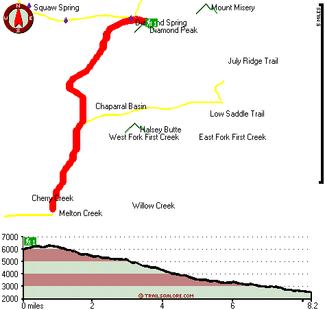
Total in and out hiking length = 16.4 miles

Total climbing distance = 6.7 miles

Difficulty : Difficult

Casual Hiking Pace: 2.5 days

Fast Hiking Pace: 1.5 days

Total elevation difference: 4283 feet


Best Western Rama Inn & Suites, Enterprise
36 miles away
This full-service Enterprise, Oregon hotel is minutes away from local attractions and is an ideal weekend getaway from busy everyday life. Enjoy a peaceful and relaxing getaway to Northwestern Orego...
  
Best Western Rivertree Inn, Clarkston
38 miles away
Stay at this Clarkston hotel and experience an exceptional staff and comfortable accommodations near Washington State's key area attractions and business locations. Located at the Gateway to Hell's C...
User input for Melton Creek Trail, Blue Mountains, Garfield County, Washington:

Submit Input:
Your Name:
Write or Paste Input here:

Upload picture:      Review Guidelines


Outdoors Recreation Near Pullman, Washington
Very comprehensive list of a variety of outdoors recreation in the vicinity of Pullman, Washington, the metro area neareast to Melton Creek Trail. Find info on campgrounds, hiking trails, ski resorts, lakes, beaches, parks, whitewater and more.

Current weather conditions at Melton Creek Trail, Blue Mountains, Garfield County, Washington
WXPort

Local climate location: POMEROY 15 miles away

Quality Inn & Suites Conference Center, Clarkston
39 miles away
The Quality Inn and Suites features a restaurant on premise with free full hot breakfast each morning for each registered adult. All rooms are newly renovated and come with a microwave, refrigerator, ...

Holiday Inn Express Hotel & Suites Pullman, Wa, Pullman
40 miles away
The Holiday Inn Express Hotel & Suites is located in the heart of the Palouse Empire, just minutes to Washington State University, ten minutes to the Pullman/Moscow Regional Airport, and ten minutes t...

More Hotels and Campgrounds Near Melton Creek Trail, Blue Mountains, Garfield County, Washington

OTHER_INFO
  Blue Mountains Campgrounds
Complete list of all the campgrounds in the Blue Mountains.

Blue Mountains Outdoors Info
Complete outdoors info for the Blue Mountains.

Washington Hiking Trails
Complete list of all hiking trails in Washington

Books about hiking trails in Washington
List of books available on Amazon.com about hiking trails in Washington.

Washington Outdoors Index
This is a very comprehensive index of outdoors activities in the great state of Washington.


TOPO
High quality water resistant topo map of Melton Creek Trail, Blue Mountains, Garfield County, Washington.

OUTDOORS_GUIDE
These outdoors activities are available near Melton Creek Trail.
 Trails Near Melton Creek Trail:
Low Saddle Trail, Asotin County County , 3 miles away,  11.2 hiking miles, 1856 feet elevation difference
July Ridge Trail, Garfield County County , 3 miles away,  5.4 hiking miles, 2063 feet elevation difference
Bear Creek Trail, Garfield County County , 3 miles away, 8.3 hiking miles, 2461 feet elevation difference
Packer Trail, Garfield County County , 4 miles away,  14.2 hiking miles, 2776 feet elevation difference
Mount Misery Trail, Columbia County County , 5 miles away,  22.8 hiking miles, 969 feet elevation difference
Tucannon River Trail, Garfield County County , 5 miles away,  6.8 hiking miles, 702 feet elevation difference
Crooked Creek Trail, Garfield County County , 6 miles away, 21.4 hiking miles, 4731 feet elevation difference
 Camp Grounds Near Melton Creek Trail:
Spruce Spring Campground, Garfield County, 5 miles away
Misery Spring Campground, Garfield County, 5 miles away
Big Spring Campground, Garfield County, 7 miles away
Wickiup Campground, Garfield County, 8 miles away
Alder Thicket Campground, Garfield County, 9 miles away
 Whitewater Near Melton Creek Trail:
Grande Ronde River, Wallowa County County , 14 miles away, Class II-III - 46 miles long (Wallowa River to Grande Ronde River)
Grande Ronde River, Asotin County County , 14 miles away, Class II-III - 19.5 miles long (Troy to Boggan's Oasis)
Grande Ronde River, Asotin County County , 30 miles away, Class II-IV - 27 miles long (Boggan's Oasis to Snake River)
Grande Ronde River, Union County County , 31 miles away, Class II-IV - 13 miles long (Elgin to Palmer Junction)
 Hotels Near Melton Creek Trail:
Best Western Rama Inn & Suites, Enterprise , 36 miles away
Best Western Rivertree Inn, Clarkston , 38 miles away
Quality Inn & Suites Conference Center, Clarkston , 39 miles away
Holiday Inn Express Hotel & Suites Pullman, Wa, Pullman , 40 miles away
Guesthouse Lewiston, Lewiston , 41 miles away

Outdoors related information copyright © Stratus-Pikpuk, Inc. - Detailed hotel information copyright © Interactive Hotel Solutions