| |
The total elevation difference for this backpacking trail is 798 feet which is lower than average. You spend the whole walk in roughly the same elevation zone, so you won’t have to worry about different climate zones along your walk. Manastash Ridge Trail is 8.4 miles long it's an average length trail. This is a two-ended backpacking trail with two trailheads, so if you can get a ride from someone, you can backcountry walk it just one way. Manastash Ridge Trail is quite long, so make sure you bring plenty of supplies. You should count on this backcountry hike taking about 7.5 hours, but you never know stuff could go wrong and you could get stuck so be prepared for that.
|
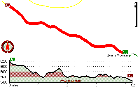
Trailhead 1 to Trailhead 2:
Total hiking length = 4.2 miles
Total climbing distance = 1.5 miles
Difficulty : Medium
Casual Hiking Pace:
3.5 hours
Fast Hiking Pace:
2 hours
Trailhead 2 to Trailhead 1:
Total hiking length = 4.2 miles
Total climbing distance = 2.3 miles
Difficulty : Medium
Casual Hiking Pace:
4 hours
Fast Hiking Pace:
2.5 hours
| | Trailhead 1 back to Trailhead 1:
Total hiking length = 8.4 miles
Total climbing distance = 3.8 miles
Difficulty : Difficult
Casual Hiking Pace:
7.5 hours
Fast Hiking Pace:
5 hours
Trailhead 2 back to Trailhead 2:
Total hiking length = 8.4 miles
Total climbing distance = 3.8 miles
Difficulty : Difficult
Casual Hiking Pace:
7.5 hours
Fast Hiking Pace:
5 hours
|
Total elevation difference: 798 feet
|


