| |
The total elevation difference for this backpacking and hiking trail is 4,030 feet which is a higher than average number. This is a one trailhead backpacking and hiking trail, so in and out is the way to trek it normally. This great outdoors trail sometimes gets very dry, so do check for current fire restrictions before you go if you plan to bring a stove or make a camp fire. Some parts of this hiking trail are much higher up than other parts of the hiking trail, so keep in mind that you may need to dress differently at different elevations. This is a great outdoors trail that is quite long, so make sure you bring plenty of supplies. This walk should take you about 4 days, so it's a wonderful thing if your backpack is big enough to do the job. With its 25.4 miles of walking distance; it's longer than many hiking trails.
|
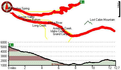
Total in and out hiking length = 25.4 miles
Total climbing distance = 11 miles
Difficulty : Difficult
Casual Hiking Pace:
4 days
Fast Hiking Pace:
2.5 days
Total elevation difference: 4030 feet
|


