| |
|
| | Lava Butte Trail is not very right next door to Hood River at all, but trekking is such an exciting thing to do, and this is an outstanding spot to do that. As long as you like the outdoors you will like Washington. When you're here in Washington backcountry hiking along one of its great outdoors hiking trails is always an exciting thing to do. Every single Washington great outdoors hiking trail has its own character. This backcountry trek shouldn't take more than 9 hours, but you never know stuff could go wrong and you could get stuck so be prepared |
|
for that. Please follow all local rules about fires and camping. At Lava Butte Trail all through the days of summer highs are in the 70's. Summer nighttime lows drop down to the 50's. High temperatures during the winter are normally in the 40's; during the dark hours in the winter
| | at Lava Butte Trail temperatures drop to the 30's. Now this wilderness hiking trail is pretty long, so do pack enough food to last the whole trip. There are so many pleasant great outdoors hiking trails for backcountry hiking in Washington, and Lava Butte Trail is one of them, and it's in Skamania County. Lava Butte Trail is a two ended wilderness trail with two trailheads, so backpacking it one way is an option if you can arrange for a ride back. The backcountry hiking trails of the Northern Cascade Range are the best way to enjoy these mountaintops. | |
|
Lava Butte Trail is 10 miles long; it's longer than many backpacking and hiking trails. You can't spend all your time indoors you need to get out once in a while, and Lava Butte Trail in Skamania County, Washington is the wilderness at its best. Lava Butte Trail sees pretty high
levels of rain; of all the months in a year December is the one with the most rain, and July on the other hand is the driest. This backcountry hiking trail is a very long backcountry hiking trail with an average amount of climbing distance which makes it an outstanding great outdoors
trail for experienced backcountry hikers in good shape. The backpacking and hiking trail stays roughly within the same elevation zone the whole time which means the conditions are about the same from start to finish. This is just one of a large number of great outdoors trails in
this vicinity. This wilderness trail has a total elevation difference of 1,401 feet which is an average number.
Briefly about the general area: This is a great river. Pete Gulch is a pleasant place to stop at in the vicinity of Lava Butte Trail, and get wet paddling
on Wind River. McClellan Meadows is a delightful place to check out; the beauty of mother nature reveals herself at Tyee Springs. Not enough hours in a day to enjoy the Northern Cascade Range. Camping at Lava Butte Trail is tremendous fun, Little Soda Springs Campground is
a tremendous local campground, and some of the water close by flows, like Oldman Creek. If only every site had this much outdoors enjoyable stuff, what a great world it would be. Lava Butte Trail is a great site to camp, Curly Creek Campground is a great site. A tour to Lava Butte
Trail wouldn't be complete without taking a look at Falls Creek Falls, and swing by Juice Creek it's a good location to have a look at.
|
|
Location of Trailhead 1: Latitude 45.9484, Longitude -121.9337 - - Directions and Road Map
Location of Trailhead 2: Latitude 45.9159, Longitude -121.8833 - - Directions and Road Map

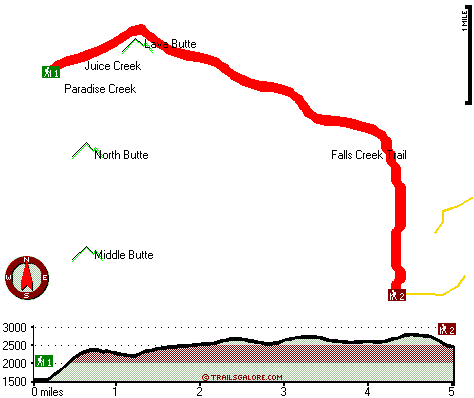
Trailhead 1 to Trailhead 2: Total hiking length = 5 miles Total climbing distance = 2.7 miles Difficulty : Medium Casual Hiking Pace:
5 hours
Fast Hiking Pace:
2.5 hours
Trailhead 2 to Trailhead 1: Total hiking length = 5 miles Total climbing distance = 1.6 miles Difficulty : Easy Casual Hiking Pace:
4 hours
Fast Hiking Pace:
2 hours
| | Trailhead 1 back to Trailhead 1: Total hiking length = 10 miles Total climbing distance = 4.3 miles Difficulty : Difficult Casual Hiking Pace:
9 hours
Fast Hiking Pace:
6 hours
Trailhead 2 back to Trailhead 2: Total hiking length = 10 miles Total climbing distance = 4.3 miles Difficulty : Difficult Casual Hiking Pace:
9 hours
Fast Hiking Pace:
6 hours
|
Total elevation difference: 1401 feet

User input for Lava Butte Trail, Northern Cascade Range, Skamania County, Washington:

Outdoors Recreation Near Hood River, Oregon Very comprehensive list of a variety of outdoors recreation in the vicinity of Hood River, Oregon, the metro area neareast to Lava Butte Trail. Find info on campgrounds, hiking trails, ski resorts, lakes, beaches, parks, whitewater and more.
More Hotels and Campgrounds Near Lava Butte Trail, Northern Cascade Range, Skamania County, Washington
| |
| |
 |
|
| These outdoors activities are available near Lava Butte Trail. |
| | Trails Near Lava Butte Trail:
 |
Falls Creek Trail, Skamania County
County
, 1 miles away, 9.1 hiking miles, 2402 feet elevation difference |
 |
Ridge Trail, Skamania County
County
, 3 miles away, 3 hiking miles, 773 feet elevation difference |
 |
Paradise Trail, Skamania County
County
, 4 miles away, 2.3 hiking miles, 1390 feet elevation difference |
 |
Huckleberry Trail, Skamania County
County
, 6 miles away, 4.4 hiking miles, 2309 feet elevation difference |
 |
Soda Peaks Trail, Skamania County
County
, 7 miles away, 0.7 hiking miles, 942 feet elevation difference |
 |
Cedar Creek Trail, Skamania County
County
, 8 miles away, 5.5 hiking miles, 2584 feet elevation difference |
 |
Observation Peak Trail, Skamania County
County
, 9 miles away, 12.4 hiking miles, 2662 feet elevation difference |
|
| | Whitewater Near Lava Butte Trail:
 |
Wind River, Skamania County
County
, 4 miles away, Class III+ - 3.4 miles long (Falls Creek to Mineral Springs Road) |
 |
Wind River, Skamania County
County
, 5 miles away, Class IV-V - 6 miles long (Ranger Station Close to Stabler to High Bridge) |
 |
Wind River, Skamania County
County
, 5 miles away, Class I-II - 7.2 miles long (Mineral Springs to Stabler) |
 |
Rush Creek, Skamania County
County
, 6 miles away, Class V+ - 5 miles long (Meadow Creek to FR 90) |
 |
Trout Creek, Skamania County
County
, 8 miles away, Class IV-V - 6.3 miles long (FR 43 to Wind River) |
|
| | Hotels Near Lava Butte Trail:
 |
Columbia Gorge Riverside Lodge, Stevenson
, 1 miles away |
 |
Wind River Cabins & Lodging, Carson
, 12 miles away |
 |
Econo Lodge Stevenson, Stevenson
, 12 miles away |
 |
Dolce Skamania Lodge, Stevenson
, 12 miles away |
 |
Skamania Lodge, Stevenson
, 12 miles away |
|
|
|
 |
|