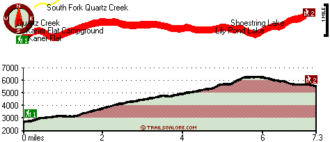
| |
|
| | Quite far from Ellensburg you come across Kaner Flat Trail, but it is a fun location to hike. Backpacking in Washington is such a fine thing to do. Finally, backpacking time is here again, and Kaner Flat Trail in Kittitas County, Washington is a really splendid location to spend some time. The total elevation difference for Kaner Flat Trail is 4,400 feet, and that is higher than average. This hiking trail has two trailheads, so hiking it one way is an option if you can arrange for a ride back. Kaner Flat Trail is a reasonably wet location commonly with |
|
a large amount of rainfall; the month with most of the snow is January, and July on the other hand is the driest. Being 14.6 miles long; it's a long great outdoors hiking trail. All through the days of summer at Kaner Flat Trail temperatures are commonly in the 60's. Once the sun
| | is down it drops down to the 40's. All through the winter the highs are commonly in the 20's; nighttime lows at Kaner Flat Trail during the winter commonly drop into the 10's. The pretty hiking trails of the Northern Cascade Range are the best way to enjoy these summits. Now this great outdoors trail is pretty long, so don't forget to pack enough supplies. The length of this hiking trail is on the longer side having an average number of uphill miles which makes this a very tough hiking trail for advanced walkers looking for a good challenge. Please follow | |
|
all local rules about fires and camping. This is just one of a large number of hiking trails in this vicinity. Different parts of this great outdoors hiking trail are at very different elevations, so keep in mind that you may need to dress differently at different elevations. There
are numerous backcountry trails in Washington, and each one has its own unique beauty. Wilderness hiking trails for trekking, and backpacking can be found all over Washington; one of them being Kaner Flat Trail in Kittitas County. Here in the splendid state of Washington trekking
is the splendid thing to do. Now, this is roughly a 2-day backcountry walk, so it's a tremendous thing if your backpack is big enough to do the job.
Briefly about the general area: Having a brilliant time in the Northern Cascade Range is uncomplicated. You'll need more
than a day to look at everything Kaner Flat Trail has to offer, you can camp at Halfway Flat Campground II; Hereford Meadow is a glorious location to stretch your legs a bit. There's so much to do here at Kaner Flat Trail that you need to camp here for a while, Little Naches
Campground is a wonderful site for that, and Horsetail Falls is an inspiring place to stop by during your stay. Some of the water close by flows, like Bumping River, and paddling on Little Naches River is so much fun. If you're here, you might as well go to Rocky Saddle, and Sawmill
Flat is a stunning spot any time of year. But wait, there's more entertaining stuff to do in the Northern Cascade Range. You don’t have to go far from Kaner Flat Trail to see the water at Milk Pond Dam, and hey, Catchup Creek is a fine local stream. Man, is there loads of enjoyable
things to do in the vicinity of Kaner Flat Trail. A spree to Kaner Flat Trail wouldn't be complete without taking a look at Cedar Spring, and American River has a great whitewater paddling spot nearby.
|
|
Location of Trailhead 1: Latitude 47.0104, Longitude -121.1291 - - Directions and Road Map
Location of Trailhead 2: Latitude 47.0222, Longitude -121.0034 - - Directions and Road Map

Trailhead 1 to Trailhead 2: Total hiking length = 7.3 miles Total climbing distance = 5 miles Difficulty : Difficult Casual Hiking Pace:
7.5 hours
Fast Hiking Pace:
4.5 hours
Trailhead 2 to Trailhead 1: Total hiking length = 7.3 miles Total climbing distance = 1.6 miles Difficulty : Difficult Casual Hiking Pace:
5.5 hours
Fast Hiking Pace:
3 hours
| | Trailhead 1 back to Trailhead 1: Total hiking length = 14.6 miles Total climbing distance = 6.6 miles Difficulty : Difficult Casual Hiking Pace:
2 days
Fast Hiking Pace:
8.5 hours
Trailhead 2 back to Trailhead 2: Total hiking length = 14.6 miles Total climbing distance = 6.6 miles Difficulty : Difficult Casual Hiking Pace:
2 days
Fast Hiking Pace:
8.5 hours
|
Total elevation difference: 4400 feet

Suncadia Resort, Cle Elum
|
10 miles away
Set on the sunny eastern slopes of the Cascades alongside the sparkling waters of the Cle Elum River and surrounded by pristine pine forest-Suncadia offers the ultimate luxury mountain resort experien...
|
| |
Stewart Lodge, Cle Elum
|
12 miles away
Carat Hotel Dusseldorf GmbH offers a wide range of rooms and amenities to make us your recreational or business spot all year around. Our rooms are exceptionally large and include unique pine furnitu...
|
|
User input for Kaner Flat Trail, Northern Cascade Range, Kittitas County, Washington:

Outdoors Recreation Near Ellensburg, Washington Very comprehensive list of a variety of outdoors recreation in the vicinity of Ellensburg, Washington, the metro area neareast to Kaner Flat Trail. Find info on campgrounds, hiking trails, ski resorts, lakes, beaches, parks, whitewater and more.
|
Current weather conditions at Kaner Flat Trail, Northern Cascade Range, Kittitas County, Washington

Local climate location: STEVENS PASS 20 miles away

           
| |
Best Western Snowcap Lodge, Cle Elum
|
12 miles away
Discover this Cle Elum, Washington hotel offering warm and comfortable accommodations near the Cascade Mountains. Welcome to the Best Western Snowcap Lodge where the service is friendly, the amenit...
|
Howard Johnson Snoqualmie/Summit, Snoqualmie Pass
|
30 miles away
On Snoqualmie Pass, The only hotel on the mountain, Outdoor Heated Swimming pool, Indoor Hot Tub and Sauna. Ski across the street - 4 mountains to ski from. Free Shuttle Service to all Base Areas at ...
|
|
More Hotels and Campgrounds Near Kaner Flat Trail, Northern Cascade Range, Kittitas County, Washington
| |
| |
 |
|
| These outdoors activities are available near Kaner Flat Trail. |
| | Trails Near Kaner Flat Trail:
 |
Quartz Creek Trail, Kittitas County
County
, 2 miles away, 6.6 hiking miles, 3413 feet elevation difference |
 |
North Fork Taneum Trail, Kittitas County
County
, 5 miles away, 18 hiking miles, 2630 feet elevation difference |
 |
Manastash Ridge Trail, Kittitas County
County
, 5 miles away, 4.2 hiking miles, 798 feet elevation difference |
 |
Frost Mountain Lookout Trail, Kittitas County
County
, 5 miles away, 4.6 hiking miles, 2361 feet elevation difference |
 |
Hicks Butte Trail, Kittitas County
County
, 6 miles away, 1.4 hiking miles, 271 feet elevation difference |
 |
Keenan Meadows Trail, Klickitat County
County
, 7 miles away, 2.9 hiking miles, 826 feet elevation difference |
 |
Fishhook Flats Trail, Kittitas County
County
, 7 miles away, 2 hiking miles, 581 feet elevation difference |
|
| | Whitewater Near Kaner Flat Trail:
 |
American River, Yakima County
County
, 5 miles away, Class II+ - 5 miles long (American Forks to Sawmill Flat) |
 |
Little Naches River, Yakima/Kittitas County
County
, 6 miles away, Class II-III+(IV) - 9.5 miles long (Matthew Creek to Little Naches Campground) |
 |
Cle Elum River, Kittitas County
County
, 10 miles away, Class II - 7.8 miles long (Cle Elum Dam to confluence with Yakima River) |
 |
American River, Yakima County
County
, 11 miles away, Class III-IV - 4.7 miles long (Hell's Crossing to American Forks) |
 |
Rattlesnake Creek - Naches Tributary, Yakima County
County
, 11 miles away, Class III - 7.7 miles long (North Fork to Nile Road Bridge) |
|
| | Hotels Near Kaner Flat Trail:
 |
Suncadia Resort, Cle Elum
, 10 miles away |
 |
Stewart Lodge, Cle Elum
, 12 miles away |
 |
Best Western Snowcap Lodge, Cle Elum
, 12 miles away |
 |
Howard Johnson Snoqualmie/Summit, Snoqualmie Pass
, 30 miles away |
 |
Hampton Inn Ellensburg, Ellensburg
, 33 miles away |
|
|
|
 |
|