Washington hiking trails - Indian Tom Trail, Blue Mountains, Asotin County

   
  In Washington you never run out of outdoors fun. There are many great wilderness trails in Washington; Indian Tom Trail in Asotin County is one of them. Indian Tom Trail is a long trip away from Lewiston, but what a good site for backcountry backpacking it is. Time to get out, and breathe some fresh air, and Indian Tom Trail in Asotin County, Washington is a good site to go. Even though this is not a very long hiking trail it's always wonderful to bring some emergency supplies, you never know what could happen. Every wilderness trail in Washington is
    stunning in its own way. This is a vicinity covered with lots of hiking trails. This is a one trailhead backcountry trail, so you'll be backcountry hiking it in and back out. This hiking trail is a normal length hiking trail having an average number of uphill miles which makes
it a glorious hiking trail for the average person looking for a glorious adventure. For the duration of the warm days of summer here at Indian Tom Trail, high temperatures mostly reach the 80's. Through the dark hours of summer temperatures descend down into the 50's. Highs all through the winter are typically in the 40's, and winter nights come with lows in the 20's to Indian Tom Trail. The beautiful hiking trails of the Blue Mountains are a really nice way to spend quality time in the fresh air. Different parts of Indian Tom Trail are at very different  
elevations, so keep in mind that you may need to dress differently at different elevations. Here in Washington backpacking is so much fun. Sometimes this hiking trail gets really dry, so do check for current fire restrictions before you go if you plan to bring a stove or make a camp fire. The total elevation difference for Indian Tom Trail is 2,258 feet, and that is about average. Being 5.4 miles long it's a mid length trek. Indian Tom Trail is a location that is reasonably dried up generally; January is when you get the most rain here, and the driest month of the year is July. And keep in mind that there could be temporary safety restrictions in site. This hike shouldn't take more than 4.5 hours, but you never know stuff could go wrong and you could get stuck so be prepared for that.

Briefly about the general area:
Get drenched paddling on Grande Ronde River, and it's a pleasant idea to explore Indian Tom Creek. This spot rocks, just explore all the enjoyable things to do near Indian Tom Trail.
Misery Spring Campground is a pleasant campground nearby, and don't leave Indian Tom Trail without first paying a visit to Arnold Spring. These mountains rock, just check out all the exciting stuff to do in the Blue Mountains. A quick spree to Ranger Creek near Indian Tom Trail is a tremendous idea, and a magnificent spot is Willow Spring Saddle. Seven Sisters Spring is an inspiring place to take a look at while here; if you came for an overnight stay Wickiup Campground is a glorious place to camp.

Location of Trailhead: Latitude 46.1089, Longitude -117.3439
- - Directions and Road Map

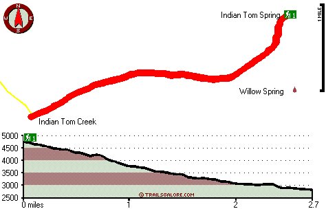
Total in and out hiking length = 5.4 miles

Total climbing distance = 2.1 miles

Difficulty : Medium

Casual Hiking Pace: 4.5 hours

Fast Hiking Pace: 3 hours

Total elevation difference: 2258 feet


Best Western Rivertree Inn, Clarkston
26 miles away
Stay at this Clarkston hotel and experience an exceptional staff and comfortable accommodations near Washington State's key area attractions and business locations. Located at the Gateway to Hell's C...
  
Quality Inn & Suites Conference Center, Clarkston
27 miles away
The Quality Inn and Suites features a restaurant on premise with free full hot breakfast each morning for each registered adult. All rooms are newly renovated and come with a microwave, refrigerator, ...
User input for Indian Tom Trail, Blue Mountains, Asotin County, Washington:

Submit Input:
Your Name:
Write or Paste Input here:

Upload picture:      Review Guidelines


Outdoors Recreation Near Lewiston, Idaho-Washington
Very comprehensive list of a variety of outdoors recreation in the vicinity of Lewiston, Idaho-Washington, the metro area neareast to Indian Tom Trail. Find info on campgrounds, hiking trails, ski resorts, lakes, beaches, parks, whitewater and more.

Current weather conditions at Indian Tom Trail, Blue Mountains, Asotin County, Washington
WXPort

Local climate location: POMEROY 8 miles away

Econo Lodge Lewiston, Lewiston
28 miles away
Short walking distance to downtown attractions and businesses. Several restaurants and shops also within walking distance. Central location with easy access to the Lewiston/Clarkson Valley. Pet accomm...

Guesthouse Lewiston, Lewiston
29 miles away
Located in Downtown District with a wonderful flare of Historic Tasteful Lewiston. Surrounded by shopping, restaurants, and night life. Greenbelt and Snake River behind hotel or rollerblading, biking,...

More Hotels and Campgrounds Near Indian Tom Trail, Blue Mountains, Asotin County, Washington

OTHER_INFO
  Blue Mountains Campgrounds
Complete list of all the campgrounds in the Blue Mountains.

Blue Mountains Outdoors Info
Complete outdoors info for the Blue Mountains.

Washington Hiking Trails
Complete list of all hiking trails in Washington

Books about hiking trails in Washington
List of books available on Amazon.com about hiking trails in Washington.

Washington Outdoors Index
This is a very comprehensive index of outdoors activities in the great state of Washington.


TOPO
High quality water resistant topo map of Indian Tom Trail, Blue Mountains, Asotin County, Washington.

OUTDOORS_GUIDE
These outdoors activities are available near Indian Tom Trail.
 Trails Near Indian Tom Trail:
Wenatchee Creek Trail, Asotin County County , 2 miles away, 8.5 hiking miles, 3641 feet elevation difference
Red Hill Gulch Trail, Asotin County County , 3 miles away, 3.3 hiking miles, 1987 feet elevation difference
South Asotin Trail, Asotin County County , 4 miles away, 1.1 hiking miles, 1041 feet elevation difference
West Wenatchee Trail, Asotin County County , 5 miles away,  6.4 hiking miles, 2178 feet elevation difference
 Camp Grounds Near Indian Tom Trail:
Wickiup Campground, Garfield County, 5 miles away
Misery Spring Campground, Garfield County, 8 miles away
Spruce Spring Campground, Garfield County, 13 miles away
Big Spring Campground, Garfield County, 14 miles away
Pataha Campground, Garfield County, 14 miles away
 Whitewater Near Indian Tom Trail:
Grande Ronde River, Asotin County County , 5 miles away, Class II-III - 19.5 miles long (Troy to Boggan's Oasis)
 Hotels Near Indian Tom Trail:
Best Western Rivertree Inn, Clarkston , 26 miles away
Quality Inn & Suites Conference Center, Clarkston , 27 miles away
Econo Lodge Lewiston, Lewiston , 28 miles away
Guesthouse Lewiston, Lewiston , 29 miles away
Holiday Inn Express LEWISTON, Lewiston , 29 miles away

Outdoors related information copyright © Stratus-Pikpuk, Inc. - Detailed hotel information copyright © Interactive Hotel Solutions