| |
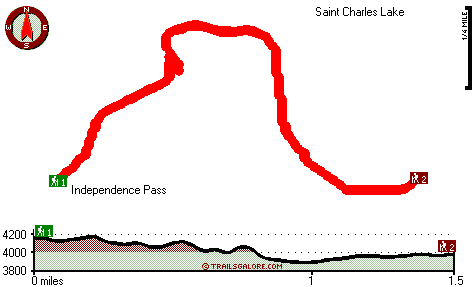
Independence Pass Interpretive Trail is a two ended wilderness hiking trail with two trailheads, so backcountry backpacking it one way is an option if you can arrange for a ride back. The hiking trail stays roughly within the same elevation zone the whole time, so you get pretty much the same conditions along the whole hiking trail. This wilderness hiking trail has a total elevation difference of 382 feet, and that is lower than average. Even though this is not a very long wilderness hiking trail it's always good to bring some emergency supplies, you never know what could happen. The time needed for this hike is roughly 2.5 hours, but of course some people walk a bit slower and some a bit faster. With its 3 miles of walking distance it's a short hiking trail.
|
Trailhead 1 to Trailhead 2:
Total hiking length = 1.5 miles
Total climbing distance = .6 miles
Difficulty : Medium
Casual Hiking Pace:
1.5 hours
Fast Hiking Pace:
.5 hours
Trailhead 2 to Trailhead 1:
Total hiking length = 1.5 miles
Total climbing distance = .6 miles
Difficulty : Medium
Casual Hiking Pace:
1.5 hours
Fast Hiking Pace:
.5 hours
| | Trailhead 1 back to Trailhead 1:
Total hiking length = 3 miles
Total climbing distance = 1.2 miles
Difficulty : Medium
Casual Hiking Pace:
2.5 hours
Fast Hiking Pace:
1.5 hours
Trailhead 2 back to Trailhead 2:
Total hiking length = 3 miles
Total climbing distance = 1.2 miles
Difficulty : Medium
Casual Hiking Pace:
2.5 hours
Fast Hiking Pace:
1.5 hours
|
Total elevation difference: 382 feet
|


