Washington hiking trails - Fire Creek Way, Northern Cascade Range, Snohomish County

   
  Every single Washington great outdoors trail has its own character. When was the last time you got out in the fresh air a bit? if you happen to be in Snohomish County of Washington, Fire Creek Way is a brilliant local trail for doing a bit of leg stretching. Fire Creek Way is a very long way away from modern life, and when you spend some time backcountry backpacking here you will feel like a whole new person. This part of Washington is always a bliss to check out during trekking season. This hiking trail is a very long hiking trail with an average amount
    of climbing distance which makes this hiking and backpacking trail brilliant for hard core backpackers looking for adventure. With its 9.2 miles of walking distance; it's longer than many backcountry trails. There's not much difference in elevation along Fire Creek Way, so you
won’t have to worry about different climate zones along your hike. Fire Creek Way is a one trailhead backpacking and hiking trail, so you're looking at an in and out backcountry walk. Don’t forget to check for any current restrictions or closures before you go. If you happen to be in Washington, why not go backcountry backpacking, it never gets boring. Fire Creek Way sees pretty high levels of precipitation; the month of November is the wettest with most of the rain; July meanwhile is the driest month. Fire Creek Way is quite long, so do pack enough food  
to last the whole trip. There are many pleasant great outdoors trails in Washington; Fire Creek Way is one of them, and it's in Snohomish County. This is one of many hiking and backpacking trails in the surrounding neighborhood. For the period of the summer months highs here at Fire Creek Way get into the 70's with night lows in the 50's. Daytime highs during the wintertime are in the 40's with winter lows in the 20's overnight here at Fire Creek Way. You should count on this backcountry walk taking about 8 hours, but of course some folks walk a bit slower and some a bit faster. The hiking trails of the Northern Cascade Range are a very great way to see these peaks. The total elevation difference for this backpacking and hiking trail is 1,437 feet, and that is about average.

Briefly about the general area:
Paddling on Downey Creek is so much fun, and why not a little side trip to Fourteenmile Creek. Yep, outdoors entertaining stuff truly is bountiful here in the Northern Cascade Range. Fire Creek Way is great enough to spend more than a day at, Owl Creek Campground is a great local campground, and soar down the rapids of Sloan Creek in a kayak.
This river is always fun. Camping at Downey Creek Campground is always a glorious experience; swing by Pumice Creek it's a nice location to stop at.

Location of Trailhead: Latitude 48.1555, Longitude -121.2661
- - Directions and Road Map

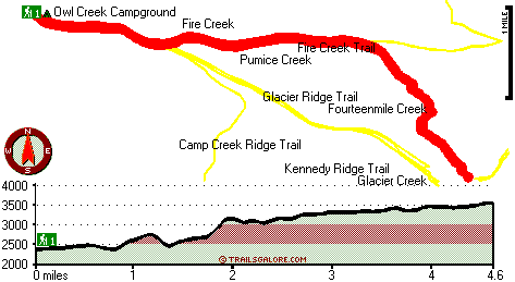
Total in and out hiking length = 9.2 miles

Total climbing distance = 3.9 miles

Difficulty : Difficult

Casual Hiking Pace: 8 hours

Fast Hiking Pace: 5.5 hours

Total elevation difference: 1437 feet


Aspen Suites at The Icicle Village Resort, Leavenworth
40 miles away
Aspen Suites at the Icicle Village Resort Leavenworth, a Magnuson Hotels affiliate, offers all non-smoking condominium-style suites and vacation rentals in the Bavarian Village of Leavenworth. Enjoy ...
  
Suncadia Resort, Cle Elum
46 miles away
Set on the sunny eastern slopes of the Cascades alongside the sparkling waters of the Cle Elum River and surrounded by pristine pine forest-Suncadia offers the ultimate luxury mountain resort experien...
User input for Fire Creek Way, Northern Cascade Range, Snohomish County, Washington:

Submit Input:
Your Name:
Write or Paste Input here:

Upload picture:      Review Guidelines


Outdoors Recreation Near Ellensburg, Washington
Very comprehensive list of a variety of outdoors recreation in the vicinity of Ellensburg, Washington, the metro area neareast to Fire Creek Way. Find info on campgrounds, hiking trails, ski resorts, lakes, beaches, parks, whitewater and more.

Current weather conditions at Fire Creek Way, Northern Cascade Range, Snohomish County, Washington
WXPort

Local climate location: DARRINGTON RANGER STN 8 miles away

Best Western Icicle Inn, Leavenworth
46 miles away
You'll find fun for the entire family at Bavarian Leavenworth's full service resort! Nestled in the eastern foothills of the Cascade Mountains, the Best Western Icicle Inn is the ideal destination for...

Quality Inn & Suites, Leavenworth
46 miles away
The Quality Inn & Suites hotel is located just one mile from the Wenatchee National Forest, which extends along the east side of the Cascade Mountains. The hotel is located 100 miles east of Seattle. ...

More Hotels and Campgrounds Near Fire Creek Way, Northern Cascade Range, Snohomish County, Washington

OTHER_INFO
  Northern Cascade Range Campgrounds
Complete list of all the campgrounds in the Northern Cascade Range.

Northern Cascade Range Outdoors Info
Complete outdoors info for the Northern Cascade Range.

Washington Hiking Trails
Complete list of all hiking trails in Washington

Books about hiking trails in Washington
List of books available on Amazon.com about hiking trails in Washington.

Washington Outdoors Index
This is a very comprehensive index of outdoors activities in the great state of Washington.


TOPO
High quality water resistant topo map of Fire Creek Way, Northern Cascade Range, Snohomish County, Washington.

OUTDOORS_GUIDE
These outdoors activities are available near Fire Creek Way.
 Trails Near Fire Creek Way:
Camp Creek Ridge Trail, Snohomish County County , 1 miles away,  9 hiking miles, 4047 feet elevation difference
Glacier Ridge Trail, Snohomish County County , 1 miles away,  14.2 hiking miles, 3891 feet elevation difference
Fire Creek Trail, Snohomish County County , 2 miles away,  23.2 hiking miles, 4244 feet elevation difference
Kennedy Ridge Trail, Snohomish County County , 2 miles away,  18.8 hiking miles, 3975 feet elevation difference
Meadow Mountain Trail, Snohomish County County , 2 miles away, 13.4 hiking miles, 4096 feet elevation difference
Lost Creek Ridge Trail, Snohomish County County , 3 miles away,  20.6 hiking miles, 4949 feet elevation difference
Sulphur Mountain Way, Snohomish County County , 6 miles away,  3.8 hiking miles, 4270 feet elevation difference
 Camp Grounds Near Fire Creek Way:
Owl Creek Campground, Snohomish County, 2 miles away
Downey Creek Campground, Snohomish County, 5 miles away
Sloan Creek Campground, Snohomish County, 5 miles away
Sulphur Creek Campground, Snohomish County, 6 miles away
East Side Buck Creek Campground, Snohomish County, 9 miles away
 Whitewater Near Fire Creek Way:
Downey Creek, Snohomish County County , 6 miles away, Class III-IV - 1 miles long (Downey Creek trail to Suiattle River)
Sloan Creek, Snohomish County County , 6 miles away, Class IV-V - 1 miles long (to National Forest Sauk)
Suiattle River, Snohomish/Skagit County County , 7 miles away, Class III+ - 16 miles long (Sulphur Creek to Rat Trap Bridge)
Sauk River - North Fork, Snohomish County County , 9 miles away, Class IV+ - 1.5 miles long (Above North Fork Falls)
Whitechuck River, Snohomish County County , 13 miles away, Class IV - 6 miles long (Bridge above Crystal Creek to Sauk River confluence)
 National Parks Near Fire Creek Way:
Lake Chelan National Recreation Area, Sedro-Woolley - WA , 68 miles away
North Cascades National Park, Sedro-Woolley - WA , 68 miles away
Ross Lake National Recreation Area, Sedro-Woolley - WA , 68 miles away
 Hotels Near Fire Creek Way:
Skyriver Inn, Skykomish , 22 miles away
Cascadia Inn, Skykomish , 22 miles away
Totem Trail Motel, Rockport , 25 miles away
Stagecoach Inn, Darrington , 26 miles away
Dirty Face Lodge, Leavenworth , 35 miles away
 Lakes Near Fire Creek Way
Camp Lake, Snohomish County , 2 miles away
Hardtack Lake, Snohomish County , 2 miles away

Outdoors related information copyright © Stratus-Pikpuk, Inc. - Detailed hotel information copyright © Interactive Hotel Solutions