Washington hiking trails - Falls Creek Trail, Northern Cascade Range, Skamania County

   
  We all need to get out in the outdoors once in a while, and Falls Creek Trail in Skamania County, Washington is a magnificent place for getting out. If you happen to be in Washington, why not go hiking, it is always a cool thing to do. Every trail in Washington has something unique to offer. There are many magnificent trails in Washington; one of those is Falls Creek Trail in Skamania County. Falls Creek Trail is a hiking trail of glorious length with an average amount of climbing distance which makes this backcountry trail tremendous for hard core backpackers
    looking for adventure. Some parts of Falls Creek Trail are much higher up than other parts of the backpacking and hiking trail which of course means you need to be prepared for different conditions on different parts of the backpacking and hiking trail. This is a region covered
with lots of backcountry trails. Being 18.2 miles long; it's a long backpacking and hiking trail. And keep in mind that there could be temporary safety restrictions in place. The hiking trails of the Northern Cascade Range are the best way to enjoy these summits. Falls Creek Trail is quite long, so don't forget to pack enough supplies. Now, this is roughly a 2.5-day backcountry trek, so better have big backpack to fit all the stuff you need. This backpacking trail has a total elevation difference of 2,402 feet which is about average. Falls Creek Trail is  
not very near Hood River at all, but when you spend some time backcountry hiking here you will feel like a whole new person. Throughout the summer highs here at Falls Creek Trail reach the 70's. When the night sets in temperatures fall down into the 50's. For the period of the winter the highs are ordinarily in the 40's with temperatures at Falls Creek Trail dipping down into the 30's during winter nights. Falls Creek Trail is a two ended backpacking trail with two trailheads which means you have the option of backcountry hiking it one way if you have someone to pick you up at the other end. Falls Creek Trail is a rather wet place ordinarily with a great deal of rain; of all the months in a year December is the one with the most rain while July is usually the driest month. In Washington you never run out of outdoors fun.

Briefly about the general area:
Put some time aside to spend at Tyee Springs since you're here at Falls Creek Trail, and a pleasant journey to McClellan Meadows is a great way to spend an afternoon. A visit to Falls Creek Falls will fill your soul with great feelings. There's so much to do here at Falls Creek Trail that you need to camp here for a while, Curly Creek Campground is a brilliant location for that.
Falls Creek Trail is close to Pete Gulch which is positively worth a visit; Indian Heaven is a delightful location any time of year. If you want a glorious time in the great outdoors just come on up to the Northern Cascade Range. Take some time to pop by Wind River Experimental Forest if you're here. Not enough hours in a day to enjoy this place. It's a great idea to pop by Black Creek, it's next to Falls Creek Trail. You'll need more than a day to discover everything Falls Creek Trail has to offer, you can camp at Little Soda Springs Campground.
Yep, outdoors enjoyable stuff truly is abundant here in the Northern Cascade Range. You can run the rapids of Wind River in close proximity to Falls Creek Trail, and a quick journey to Oldman Creek is without doubt a good idea.

Location of Trailhead 1: Latitude 45.905, Longitude -121.9395
- - Directions and Road Map

Location of Trailhead 2: Latitude 45.9672, Longitude -121.8454
- - Directions and Road Map


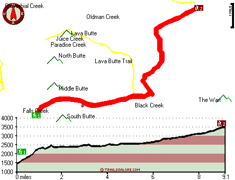
Trailhead 1 to Trailhead 2:
Total hiking length = 9.1 miles
Total climbing distance = 5.7 miles
Difficulty : Difficult
Casual Hiking Pace: 9 hours
Fast Hiking Pace: 5 hours

Trailhead 2 to Trailhead 1:
Total hiking length = 9.1 miles
Total climbing distance = 1.1 miles
Difficulty : Difficult
Casual Hiking Pace: 6.5 hours
Fast Hiking Pace: 3.5 hours
    Trailhead 1 back to Trailhead 1:
Total hiking length = 18.2 miles
Total climbing distance = 6.8 miles
Difficulty : Difficult
Casual Hiking Pace: 2.5 days
Fast Hiking Pace: 1.5 days

Trailhead 2 back to Trailhead 2:
Total hiking length = 18.2 miles
Total climbing distance = 6.8 miles
Difficulty : Difficult
Casual Hiking Pace: 2.5 days
Fast Hiking Pace: 1.5 days

Total elevation difference: 2402 feet


Skamania Lodge, Stevenson
12 miles away
Skamania Lodge is located in the beautiful Columbia River Gorge just 45 minutes from Portland International Airport. Discover all the luxuries of this Pacific Northwest style resort, including 18-hole...
  
Best Western Columbia River Inn, Cascade Locks
13 miles away
Enjoy the spectacular scenery of the Columbia River Gorge at this Cascade Locks hotel. The Best Western Columbia River Inn is a fully non-smoking property located only 45 miles from Portland, Oregon ...
User input for Falls Creek Trail, Northern Cascade Range, Skamania County, Washington:

Submit Input:
Your Name:
Write or Paste Input here:

Upload picture:      Review Guidelines


Outdoors Recreation Near Hood River, Oregon
Very comprehensive list of a variety of outdoors recreation in the vicinity of Hood River, Oregon, the metro area neareast to Falls Creek Trail. Find info on campgrounds, hiking trails, ski resorts, lakes, beaches, parks, whitewater and more.

Current weather conditions at Falls Creek Trail, Northern Cascade Range, Skamania County, Washington
WXPort

Local climate location: COUGAR 16 miles away

Bonneville Hot Springs Resort, North Bonneville
15 miles away
This property is a 100 percent nonsmoking facility. Up to two children 16 and under stay free in same room with adult. Over two children are 10.00USD per child per day and purchase of rollaway is requ...

Comfort Suites Hood River, Hood River
27 miles away
The Comfort Suites is centrally located for business and leisure travelers. This Hood River hotel is only one mile from the Mount Hood Railroad. Area attractions include Beacon Rock, the Columbia Rive...

More Hotels and Campgrounds Near Falls Creek Trail, Northern Cascade Range, Skamania County, Washington

OTHER_INFO
  Northern Cascade Range Campgrounds
Complete list of all the campgrounds in the Northern Cascade Range.

Northern Cascade Range Outdoors Info
Complete outdoors info for the Northern Cascade Range.

Washington Hiking Trails
Complete list of all hiking trails in Washington

Books about hiking trails in Washington
List of books available on Amazon.com about hiking trails in Washington.

Washington Outdoors Index
This is a very comprehensive index of outdoors activities in the great state of Washington.


TOPO
High quality water resistant topo map of Falls Creek Trail, Northern Cascade Range, Skamania County, Washington.

OUTDOORS_GUIDE
These outdoors activities are available near Falls Creek Trail.
 Trails Near Falls Creek Trail:
Lava Butte Trail, Skamania County County , 1 miles away, 5 hiking miles, 1401 feet elevation difference
Ridge Trail, Skamania County County , 3 miles away, 3 hiking miles, 773 feet elevation difference
Paradise Trail, Skamania County County , 5 miles away, 2.3 hiking miles, 1390 feet elevation difference
Huckleberry Trail, Skamania County County , 6 miles away, 4.4 hiking miles, 2309 feet elevation difference
Cedar Creek Trail, Skamania County County , 7 miles away, 5.5 hiking miles, 2584 feet elevation difference
Soda Peaks Trail, Skamania County County , 8 miles away, 0.7 hiking miles, 942 feet elevation difference
Observation Peak Trail, Skamania County County , 10 miles away,  12.4 hiking miles, 2662 feet elevation difference
 Camp Grounds Near Falls Creek Trail:
Little Soda Springs Campground, Skamania County, 6 miles away
Curly Creek Campground, Skamania County, 8 miles away
Forlorn Lakes Campground, Skamania County, 10 miles away
Observation Berryfield Campground, Skamania County, 10 miles away
Lower Falls Campground, Skamania County, 11 miles away
 Whitewater Near Falls Creek Trail:
Wind River, Skamania County County , 5 miles away, Class III+ - 3.4 miles long (Falls Creek to Mineral Springs Road)
Wind River, Skamania County County , 6 miles away, Class IV-V - 6 miles long (Ranger Station Close to Stabler to High Bridge)
Wind River, Skamania County County , 6 miles away, Class I-II - 7.2 miles long (Mineral Springs to Stabler)
Rush Creek, Skamania County County , 6 miles away, Class V+ - 5 miles long (Meadow Creek to FR 90)
Panther Creek, Skamania County County , 7 miles away, Class IV+ - 5 miles long (to confluence with Lower Wind River)
 National Parks Near Falls Creek Trail:
Mount Rainier National Park, Ashford - WA , 39 miles away
 Hotels Near Falls Creek Trail:
Skamania Lodge, Stevenson , 12 miles away
Best Western Columbia River Inn, Cascade Locks , 13 miles away
Bonneville Hot Springs Resort, North Bonneville , 15 miles away
Comfort Suites Hood River, Hood River , 27 miles away
Best Western Hood River Inn, Hood River , 29 miles away

Outdoors related information copyright © Stratus-Pikpuk, Inc. - Detailed hotel information copyright © Interactive Hotel Solutions