| |
|
| | Alright, enough of spending all this time inside a building, time to get out, and East Butte Creek Trail in Columbia County, Washington is such a great location. Relatively far from La Grande you locate East Butte Creek Trail, but it is one of many fine great outdoors trails in this vicinity. There are many nice trails in Washington, and East Butte Creek Trail in Columbia County is one of them. This is a neighborhood covered with lots of hiking trails. These backpacking trails here in the Blue Mountains are a very delightful way to see these mountaintops. |
|
And keep in mind that there could be temporary safety restrictions in place. When you're here in Washington backcountry backpacking along one of its trails is a perfect idea. Every single Washington trail is different from the others. East Butte Creek Trail is 27.4 miles long;
| | it's longer than many backpacking and hiking trails. For the period of the summertime months at East Butte Creek Trail temperatures are mostly in the 80's. Once the sun is down it falls down to the 50's. Through the wintertime this location gets highs in the 30's, and nighttime lows at East Butte Creek Trail through the wintertime usually fall into the 20's. Now, this is roughly a 4-day hike, so it's a perfect thing if your backpack is big enough to do the job. This hiking trail has a total elevation difference of 3,023 feet, and that is higher than average. | |
|
East Butte Creek Trail goes through some very different elevations which of course means you need to be prepared for different conditions on different parts of the backpacking and hiking trail. This is a long backpacking and hiking trail, so don't forget to pack enough supplies.
East Butte Creek Trail has only one trailhead, so in and out is the way to trek it normally. This backpacking trail is a backpacking trail of delightful length with an average amount of climbing distance which makes it a great hiking trail for experienced hikers in good shape.
Backcountry backpacking in Washington is such a wonderful thing to do. Sometimes this backpacking and hiking trail gets really dry, so make sure you check current conditions and fire restrictions with local forest authorities before you head out. East Butte Creek Trail is usually
a quite dehydrated spot; the wettest month of the year is usually December, that's the one that rains the most, and the driest month of the year is July.
Briefly about the general area: At this river you will always have a good time. Tallow Flat is right here at East
Butte Creek Trail. There's so much to do here at East Butte Creek Trail that you need to camp here for a while, Teepee Campground is a splendid spot for that. Getting to Dickinson Creek from East Butte Creek Trail is trouble-free; East Butte Creek Trail is magnificent enough to
spend more than a day at, Tepee Campground is a magnificent local campground. You just can't picture the amount of outdoors fun things the Blue Mountains has to offer. This location is peerless, just look at all the cool things to do in the vicinity of East Butte Creek Trail.
A great place for whitewater paddling in the vicinity of East Butte Creek Trail is Grande Ronde River, and a trip to East Butte Creek Trail wouldn't be complete without taking a look at Moolack Spring. Whohoo, so many fun things in one place! The Blue Mountains is excellent! A
great site like Ant Flat here at East Butte Creek Trail is too delightful to miss; why not take a little trip to King Creek while you're here. While staying at East Butte Creek Trail you could always discover Box Canyon, and a short tour to Hatfield Spring is always worthwhile.
|
|
Location of Trailhead: Latitude 46.1773, Longitude -117.7174 - - Directions and Road Map
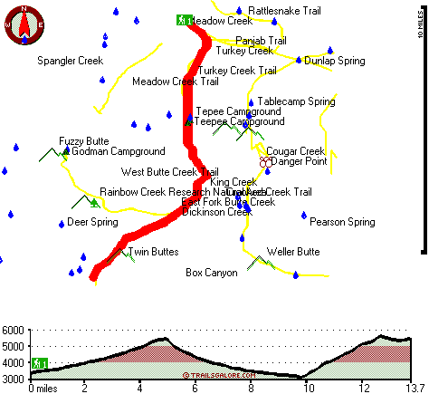
Total in and out hiking length = 27.4 miles
Total climbing distance = 12.9 miles
Difficulty : Difficult
Casual Hiking Pace:
4 days
Fast Hiking Pace:
3 days
Total elevation difference: 3023 feet

Walla Walla Super 8 Motel, Walla Walla
|
40 miles away
The Super 8 in Walla Walla is located just off Hwy. 12 Exit Wilbur Ave. The property features 101 rooms, Super Start Breakfast, Free Wireless Hi Speed Internet, Indoor Pool and Spa, Copy & Fax se...
|
| |
Walla Walla East Main St. Travelodge, Walla Walla
|
42 miles away
The Walla Walla Travelodge is in a quiet Downtown location Closest accommodation to Whitman College It is only minutes to Walla Walla College & Walla Walla Community College the Fairgrounds Washin...
|
|
User input for East Butte Creek Trail, Blue Mountains, Columbia County, Washington:

Outdoors Recreation Near La Grande, Oregon Very comprehensive list of a variety of outdoors recreation in the vicinity of La Grande, Oregon, the metro area neareast to East Butte Creek Trail. Find info on campgrounds, hiking trails, ski resorts, lakes, beaches, parks, whitewater and more.
|
Current weather conditions at East Butte Creek Trail, Blue Mountains, Columbia County, Washington

Local climate location: DAYTON 19 miles away

           
| |
Walla Walla Motor Hotel, Walla Walla
|
42 miles away
Located in the heart of downtown Walla Walla, right across from Whitman College, is the Walla Walla Vineyard Inn. Downtown restaurants, museums, wineries and shopping are located within steps of our ...
|
Budget Inn Walla Walla, Walla Walla
|
42 miles away
We are located in the heart of Historical Downtown Walla Walla just minutes from Whitman College, close to many local wineries including Pepper Bridge, Cougar Crest, and Fort Walla Walla Cellars. Wall...
|
|
More Hotels and Campgrounds Near East Butte Creek Trail, Blue Mountains, Columbia County, Washington
| |
| |
 |
|
| These outdoors activities are available near East Butte Creek Trail. |
| | Trails Near East Butte Creek Trail:
 |
West Butte Creek Trail, Columbia County
County
, 2 miles away, 10.6 hiking miles, 3127 feet elevation difference |
 |
Turkey Creek Trail, Columbia County
County
, 2 miles away, 9.8 hiking miles, 2735 feet elevation difference |
 |
Meadow Creek Trail, Columbia County
County
, 3 miles away, 4 hiking miles, 1798 feet elevation difference |
 |
Panjab Trail, Columbia County
County
, 4 miles away, 7.2 hiking miles, 2647 feet elevation difference |
 |
Grizzly Bear Trail, Columbia County
County
, 5 miles away, 25.2 hiking miles, 3837 feet elevation difference |
 |
Rattlesnake Trail, Columbia County
County
, 5 miles away, 9 hiking miles, 2988 feet elevation difference |
 |
Smooth Ridge Trail, Columbia County
County
, 7 miles away, 36.8 hiking miles, 5156 feet elevation difference |
|
| | Whitewater Near East Butte Creek Trail:
 |
Grande Ronde River, Wallowa County
County
, 18 miles away, Class II-III - 46 miles long (Wallowa River to Grande Ronde River) |
 |
Grande Ronde River, Union County
County
, 25 miles away, Class II-IV - 13 miles long (Elgin to Palmer Junction) |
 |
Grande Ronde River, Asotin County
County
, 26 miles away, Class II-III - 19.5 miles long (Troy to Boggan's Oasis) |
 |
Grande Ronde River, Union County
County
, 36 miles away, Class I - 32 miles long (Riverside City Park to Elgin) |
 |
Grande Ronde River, Asotin County
County
, 42 miles away, Class II-IV - 27 miles long (Boggan's Oasis to Snake River) |
|
| | Hotels Near East Butte Creek Trail:
 |
Pioneer Motel, Pomeroy
, 20 miles away |
 |
Weinhard Hotel, Dayton
, 20 miles away |
 |
Blue Mountain Motel, Dayton
, 21 miles away |
 |
Dayton Motel, Dayton
, 21 miles away |
 |
Stampede Inn, Elgin
, 29 miles away |
|
|
|
 |
|