| |
|
| | This part of Washington is always a joy to pop by during backcountry trekking season. Spending too much time indoors got you down? No problem, Daisy Trail in Ferry County, Washington is the outdoors at its best. If you happen to be in Washington, why not go backcountry trekking, it is so much fun. Far from civilization you locate Daisy Trail, and It's always exciting to walk here. At parts of the year this vicinity sees very little rain, so do check for current fire restrictions before you go if you plan to bring a stove or make a camp fire. Please follow |
|
all local rules about fires and camping. This is one of a very small number of hiking and backpacking trails in this vicinity. The total elevation difference for Daisy Trail is 1,092 feet which is an average number. This is a long great outdoors hiking trail, so make sure you bring
| | plenty of supplies. This hiking trail has only one trailhead, so in and out is the way to trek it normally. Daisy Trail stays roughly within the same elevation zone the whole time, so you won’t have to worry about different climate zones along your walk. There are numerous wilderness trails in Washington, and each one is different from the others. Brilliant wilderness trails in Washington are in abundance, and Daisy Trail in Ferry County is one of them. Throughout the summertime at Daisy Trail highs are usually in the 80's. Once the sun is down it drops down | |
|
to the 40's. The winter brings highs down to the 20's, and overnight lows in the 10's for Daisy Trail. With its 12.8 miles of walking distance; it's longer than many trails. At Daisy Trail you don’t see much rain; through December this area sees the most snow; October is when it's
the driest. This backcountry hike should take you about 2 days, so better have big backpack to fit all the stuff you need. The length of Daisy Trail is on the longer side having an average number of uphill miles which makes this a very tough hiking and backpacking trail for advanced
backcountry trekkers looking for a glorious challenge.
Briefly about the general area: West Fork Hall Creek is a stream that you may encounter while here; you can stay the night at Rocky Point Campground. Whitewater paddling is not for everybody but if it's for you then
we recommend Sherman Creek; Daisy Trail is a pleasant site to visit for more than one day, Buckskin Creek Campground is a pleasant site to camp nearby. North Fork Hall Creek flows through this neighborhood.
|
|
Location of Trailhead: Latitude 48.3512, Longitude -118.554 - - Directions and Road Map
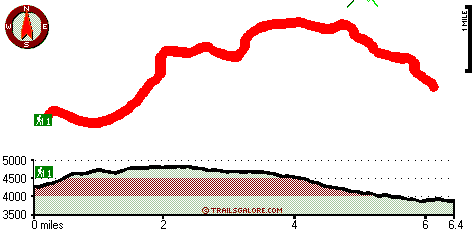
Total in and out hiking length = 12.8 miles
Total climbing distance = 5.8 miles
Difficulty : Difficult
Casual Hiking Pace:
2 days
Fast Hiking Pace:
7.5 hours
Total elevation difference: 1092 feet

Comfort Inn Colville, Colville
|
42 miles away
Easy access to shopping, business offices, Lake Roosevelt, golf courses & Keller Museum. Central location for hunting, fishing, skiing & snowmobiling. Pet deposit: 50.00 USD per stay. Pet accommodatio...
|
| |
|
User input for Daisy Trail, Ferry County, Washington:

Outdoors Recreation Near Moses Lake, Washington Very comprehensive list of a variety of outdoors recreation in the vicinity of Moses Lake, Washington, the metro area neareast to Daisy Trail. Find info on campgrounds, hiking trails, ski resorts, lakes, beaches, parks, whitewater and more.
More Hotels and Campgrounds Near Daisy Trail, Ferry County, Washington
| |
|
| These outdoors activities are available near Daisy Trail. |
| | Trails Near Daisy Trail:
 |
White Mountain Trail, Ferry County
County
, 7 miles away, 8 hiking miles, 3438 feet elevation difference |
 |
Seventeenmile Trail, Ferry County
County
, 10 miles away, 7.5 hiking miles, 695 feet elevation difference |
|
| | Whitewater Near Daisy Trail:
 |
Sherman Creek, Ferry County
County
, 20 miles away, Class II-III - 5 miles long (Log Flume interpretive site to Inchelium Road) |
 |
Sherman Creek, Ferry County
County
, 23 miles away, Class V - 1 miles long (turnout to fish hatchery) |
|
|
|
 |
|