| |
|
| | If you happen to be in Washington, why not go trekking, it is so much fun. Because Clear Lost Trail is very isolated from civilization, backcountry trekking along this backcountry hiking trail is very enjoyable. Spending too much time indoors got you down? No problem, Clear Lost Trail in Lewis County, Washington is such a wonderful place. The total elevation difference for Clear Lost Trail is 3,909 feet which is higher than average. Clear Lost Trail is quite long, so don't forget to pack enough supplies. This hiking trail is a very long hiking trail having |
|
an average number of uphill miles which makes it a fine hiking trail for experienced backcountry walkers in perfect shape. This is just one of a large number of hiking trails in this vicinity. This hike should take you about 1.5 days, so make sure you've got all your overnight
| | gear packed. Different parts of Clear Lost Trail are at very different elevations, so keep in mind that you may need to dress differently at different elevations. And keep in mind that there could be temporary safety restrictions in spot. Every Washington wilderness hiking trail is different from the others. Hiking and backpacking trails are nice and plentiful in Washington, and Clear Lost Trail is one of them, and it's in Lewis County. During the warmest time of the year, highs typically are in the 60's at Clear Lost Trail with nighttime lows in the 40's. | |
|
For the duration of the wintertime this location gets highs in the 30's with winter lows in the 10's overnight here at Clear Lost Trail. Clear Lost Trail is a one trailhead trail, so you're looking at an in and out backcountry trek. With its 10.6 miles of walking distance; it's
considered a longer backcountry hike. A visit to Washington is not complete without some backcountry hiking. The delightful hiking trails of the Northern Cascade Range are the best way to enjoy these peaks. Clear Lost Trail generally gets much precipitation; most of the snow falls
all through January, and July is the month with the least moisture.
Briefly about the general area: This river is so great. Lily Basin is right here at Clear Lost Trail, and while you're here you ought to stop at Cortright Point. You'll need more than a day to look at
everything Clear Lost Trail has to offer, you can camp at Soda Springs Campground, and why not a little side spree to Coyote Creek. And if that's not enough, there's lots more to do in the neighborhood of Clear Lost Trail. There's so much to do here at Clear Lost Trail that
you need to camp here for a while, Knuppenburg Lake Campground is a delightful location for that; a good place to check out close by is Packwood Saddle. You can run the rapids of Cowlitz River - Clear Fork in the neighborhood of Clear Lost Trail, and swing by Millridge Creek it's
a delightful place to check out. But wait, there's more fun things to do in the Northern Cascade Range. A journey to Fish Ladder Falls will fill your spirit with glorious feelings, and there's whitewater on Summit Creek for all you adrenaline people. Not enough hours in a day to enjoy the Northern Cascade Range.
|
|
Location of Trailhead: Latitude 46.6252, Longitude -121.4451 - - Directions and Road Map
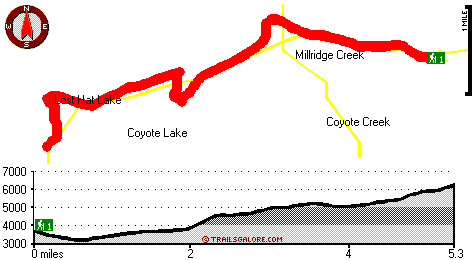
Total in and out hiking length = 10.6 miles
Total climbing distance = 4.3 miles
Difficulty : Difficult
Casual Hiking Pace:
1.5 days
Fast Hiking Pace:
6 hours
Total elevation difference: 3909 feet

Suncadia Resort, Cle Elum
|
43 miles away
Set on the sunny eastern slopes of the Cascades alongside the sparkling waters of the Cle Elum River and surrounded by pristine pine forest-Suncadia offers the ultimate luxury mountain resort experien...
|
| |
Best Western Hood River Inn, Hood River
|
43 miles away
This Hood River hotel in Oregon offers comfortable accommodations with scenic views of the Columbia River. Located in the hub of the Columbia River Gorge, the Best Western Hood River Inn is the perfe...
|
|
User input for Clear Lost Trail, Northern Cascade Range, Lewis County, Washington:

Outdoors Recreation Near Hood River, Oregon Very comprehensive list of a variety of outdoors recreation in the vicinity of Hood River, Oregon, the metro area neareast to Clear Lost Trail. Find info on campgrounds, hiking trails, ski resorts, lakes, beaches, parks, whitewater and more.
More Hotels and Campgrounds Near Clear Lost Trail, Northern Cascade Range, Lewis County, Washington
| |
| |
 |
|
| These outdoors activities are available near Clear Lost Trail. |
| | Trails Near Clear Lost Trail:
 |
Clear Fork Trail, Lewis County
County
, 2 miles away, 18.2 hiking miles, 2000 feet elevation difference |
 |
Coyote Trail, Lewis County
County
, 2 miles away, 26 hiking miles, 3992 feet elevation difference |
 |
Sand Lake Trail, Lewis County
County
, 3 miles away, 7 hiking miles, 1973 feet elevation difference |
 |
Cortright Creek Trail, Lewis County
County
, 4 miles away, 12.6 hiking miles, 2935 feet elevation difference |
 |
Kincaid Trail, Lewis County
County
, 5 miles away, 15 hiking miles, 2899 feet elevation difference |
 |
Lake Trail, Lewis County
County
, 5 miles away, 10.8 hiking miles, 1640 feet elevation difference |
 |
Cowlitz Trail, Lewis County
County
, 5 miles away, 10.6 hiking miles, 2199 feet elevation difference |
|
| | Whitewater Near Clear Lost Trail:
 |
Summit Creek, Lewis County
County
, 5 miles away, Class V+ - 5 miles long (Soda Springs to Highway 123) |
 |
Cowlitz River - Clear Fork, Lewis County
County
, 5 miles away, Class V+ - 5 miles long (Lava Creek to La Wis Wis Campground) |
 |
Ohanepecosh River, Lewis County
County
, 8 miles away, Class V - 4.7 miles long (Ohanepecosh Campground to La Wis Wis Campground) |
 |
Cispus River, Lewis County
County
, 9 miles away, Class V - 4 miles long (Goat Creek to FR 2160) |
 |
Chinook Creek, Pierce County
County
, 10 miles away, Class IV-V - 5 miles long (Deer Creek to Cedar Flats) |
|
| | Hotels Near Clear Lost Trail:
 |
Mt View Lodge, Packwood
, 13 miles away |
 |
Cowlitz River Lodge, Packwood
, 13 miles away |
 |
Inn of Packwood, Packwood
, 13 miles away |
 |
Hotel Packwood, Packwood
, 13 miles away |
 |
Crest Trail Lodge, Packwood
, 14 miles away |
|
|
|
 |
|