| |
|
| | In Washington you never run out of outdoors fun. Going for a backcountry walk here in Washington is something that is always fun to do. Trails are wonderful and plentiful in Washington; Bonaparte Trail is one of them, and it's in Okanogan County. At parts of the year this vicinity sees very little rain, so make sure you check current conditions and fire restrictions with local forest authorities before you head out. Every single Washington hiking trail is worth backpacking. Far from society you find Bonaparte Trail, and backcountry hiking it is always enjoyable. |
|
Bonaparte Trail is a one trailhead backcountry trail, so you'll be backpacking it in and back out. Around Bonaparte Trail you don’t get a lot of rain; all through the month of December you get the most snow around here while July is the month with the least amount of precipitation.
| | This is one of a very small number of backcountry trails in this area. Being 4.8 miles long it's a mid length backcountry trek. Please follow all local rules about fires and camping. Even though this is not a very long backcountry hiking trail it's always brilliant to bring some emergency supplies, you never know what could happen. Can’t wait to get out in the great outdoors, Bonaparte Trail in Okanogan County, Washington is just the site. Different parts of this hiking trail are at very different elevations, so keep in mind that you may need to dress | |
|
differently at different elevations. The time needed for this trek is roughly 4.5 hours, but of course some folks walk a bit slower and some a bit faster. This backcountry trail has a total elevation difference of 2,363 feet which is about average. For the duration of the warmest
time of the year at Bonaparte Trail temperatures are ordinarily in the 80's. Through the moonlight hours it's generally in the 50's. The winter brings highs down to the 30's while the cold winter nights at Bonaparte Trail are in the 10's. Bonaparte Trail is a normal length backcountry
trail with an average amount of climbing distance which makes this backcountry trail brilliant for the average walker looking for a cool adventure.
Briefly about the general area: There's so much to do here at Bonaparte Trail that you need to camp here for a while, Bonaparte
Lake Resort and Restaurant is a great place for that. Stay the night at Lost Lake Campground, and a tour to Bonaparte Trail wouldn't be complete without taking a look at Lightning Spring.
|
|
Location of Trailhead: Latitude 48.8164, Longitude -119.123 - - Directions and Road Map
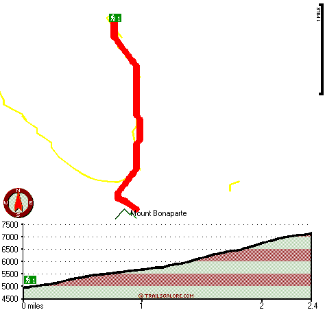
Total in and out hiking length = 4.8 miles
Total climbing distance = 2.2 miles
Difficulty : Medium
Casual Hiking Pace:
4.5 hours
Fast Hiking Pace:
3 hours
Total elevation difference: 2363 feet

Best Western Peppertree Inn at Omak, Omak
|
32 miles away
Guests will find themselves just 50 miles from the Canadian border while staying at this new full-service, Omak, Washington hotel. Enjoy beautiful views of Omak Mountain, luxurious amenities and gre...
|
| |
Rodeway Inn & Suites, Omak
|
33 miles away
Hotel offers excellent rooms and suites with Free unlimited Wireless internet, Refrigerator, Microwave. Rooms with Individual Whirlpool Bath Tubs and rooms with Fireplaces available. Free Deluxe Conti...
|
|
User input for Bonaparte Trail, Okanogan County, Washington:

Outdoors Recreation Near Moses Lake, Washington Very comprehensive list of a variety of outdoors recreation in the vicinity of Moses Lake, Washington, the metro area neareast to Bonaparte Trail. Find info on campgrounds, hiking trails, ski resorts, lakes, beaches, parks, whitewater and more.
More Hotels and Campgrounds Near Bonaparte Trail, Okanogan County, Washington
| |
|
| These outdoors activities are available near Bonaparte Trail. |
| | Trails Near Bonaparte Trail:
 |
South Side Trail, Okanogan County
County
, 1 miles away, 8.9 hiking miles, 1801 feet elevation difference |
 |
Antoine Trail, Okanogan County
County
, 2 miles away, 7.5 hiking miles, 3014 feet elevation difference |
 |
Mill Creek Trail, Okanogan County
County
, 5 miles away, 2.7 hiking miles, 1222 feet elevation difference |
|
|
|
 |
|