| |
|
| | Gotta get out of the city man, and if you happen to be in Ferry County of Washington, Bodie Tonata Creek Trail is a splendid local backpacking and hiking trail for doing a bit of leg stretching. Trekking in Washington is such a magnificent thing to do. Every Washington hiking trail has its own unique attractiveness. Bodie Tonata Creek Trail is a very long way away from society, and backpacking is such a fun thing to do, and this is a splendid place to do that. Bodie Tonata Creek Trail gets very little precipitation; most of the snow falls throughout |
|
December, and October is the month with the least moisture. And keep in mind that there could be temporary safety restrictions in location. With its 9.4 miles of walking distance; it's considered a longer walk. Here in the brilliant state of Washington backpacking is so much fun.
| | Great hiking trails in Washington are in abundance, and Bodie Tonata Creek Trail is one of them, and it's in Ferry County. Throughout the summertime months, highs ordinarily are in the 80's at Bodie Tonata Creek Trail with nighttime lows in the 40's. Highs through the wintertime are frequently in the 20's while the cold winter nights at Bodie Tonata Creek Trail are in the 10's. Some parts of this wilderness hiking trail are much higher up than other parts of the wilderness hiking trail, so keep in mind that you may need to dress differently at different | |
|
elevations. This is a long backpacking trail, so do pack enough food to last the whole trip. Bodie Tonata Creek Trail is a wilderness hiking trail of good length with an average amount of climbing distance which makes it a fine backpacking and hiking trail for experienced backcountry
walkers in tremendous shape. This walk shouldn't take more than 8 hours, but of course some folks walk a bit slower and some a bit faster. This neighborhood does get very dry sometimes, so make sure you check current conditions and fire restrictions with local forest authorities
before you head out. There are so many backpacking and hiking trails in this vicinity. This is a two-ended backpacking and hiking trail with two trailheads, so backcountry hiking it one way is an option if you can arrange for a ride back. The total elevation difference for this
backpacking and hiking trail is 2,194 feet which is about average.
Briefly about the general area: A great location to check out close to Bodie Tonata Creek Trail is Resner Canyon, and close by you'll locate a wooded area called Colville National Forest. If you want
a good time in the great outdoors, just come on down to Bodie Tonata Creek Trail. All our national parks are glorious places to explore, and Lake Roosevelt National Recreation Area is no exception. A delightful location to camp here at Bodie Tonata Creek Trail is Beaver Lake
Campground, and if you're here, you could take a look at Coogan Creek. Bodie Tonata Creek Trail is wonderful enough to spend more than a day at, Sweat Creek Campground is a wonderful local campground; Bodie Spring is always fun to check out. Marias Creek flows through this region; Kelly Spring is a beautiful location to stop at while you're at Bodie Tonata Creek Trail.
|
|
Location of Trailhead 1: Latitude 48.8658, Longitude -118.7881 - - Directions and Road Map
Location of Trailhead 2: Latitude 48.8291, Longitude -118.8339 - - Directions and Road Map

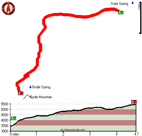
Trailhead 1 to Trailhead 2: Total hiking length = 4.7 miles Total climbing distance = 3.1 miles Difficulty : Medium Casual Hiking Pace:
5 hours
Fast Hiking Pace:
3 hours
Trailhead 2 to Trailhead 1: Total hiking length = 4.7 miles Total climbing distance = .6 miles Difficulty : Easy Casual Hiking Pace:
3.5 hours
Fast Hiking Pace:
1.5 hours
| | Trailhead 1 back to Trailhead 1: Total hiking length = 9.4 miles Total climbing distance = 3.7 miles Difficulty : Difficult Casual Hiking Pace:
8 hours
Fast Hiking Pace:
5 hours
Trailhead 2 back to Trailhead 2: Total hiking length = 9.4 miles Total climbing distance = 3.7 miles Difficulty : Difficult Casual Hiking Pace:
8 hours
Fast Hiking Pace:
5 hours
|
Total elevation difference: 2194 feet

User input for Bodie Tonata Creek Trail, Ferry County, Washington:

Outdoors Recreation Near Moses Lake, Washington Very comprehensive list of a variety of outdoors recreation in the vicinity of Moses Lake, Washington, the metro area neareast to Bodie Tonata Creek Trail. Find info on campgrounds, hiking trails, ski resorts, lakes, beaches, parks, whitewater and more.
More Hotels and Campgrounds Near Bodie Tonata Creek Trail, Ferry County, Washington
| |
|
| These outdoors activities are available near Bodie Tonata Creek Trail. |
| | Trails Near Bodie Tonata Creek Trail:
 |
Bodie Mountain Trail, Ferry County
County
, 2 miles away, 2.5 hiking miles, 648 feet elevation difference |
 |
Empire Drive Trail, Ferry County
County
, 4 miles away, 5.4 hiking miles, 856 feet elevation difference |
 |
Laws Trail, Ferry County
County
, 4 miles away, 2.7 hiking miles, 1006 feet elevation difference |
 |
Storm King Trail, Ferry County
County
, 5 miles away, 5.3 hiking miles, 1620 feet elevation difference |
 |
Maple Mountain Trail, Okanogan County
County
, 7 miles away, 7.8 hiking miles, 1620 feet elevation difference |
 |
Fawns Mill Trail, Okanogan County
County
, 10 miles away, 5 hiking miles, 1351 feet elevation difference |
|
|
|
 |
|