| |
|
| | Alright, enough of spending all this time inside a building, time to get out, and Backbone Ridge Trail in Lewis County, Washington is a really glorious place to spend some time. Tremendous hiking and backpacking trails in Washington are in abundance, and one of these is Backbone Ridge Trail in Lewis County. There are plenty of hiking and backpacking trails in Washington; each one of them is worth hiking. Different parts of this backcountry trail are at very different elevations which of course means you need to be prepared for different conditions on different |
|
parts of the backcountry trail. Hiking in Washington is a magnificent idea. This backcountry walk shouldn't take more than 4 hours, but of course some folks walk a bit slower and some a bit faster. Backcountry trekking here in the Northern Cascade Range is the best way to enjoy
| | these summits. High temperatures at Backbone Ridge Trail through the months of summer are in the 70's. Throughout the dark hours of summer temperatures plunge down into the 40's. Throughout the winter highs are typically in the 30's; nighttime lows in the 20's for Backbone Ridge Trail. Backbone Ridge Trail is a very long way away from society, and what a fine place for backpacking it is. All the water falling down from the sky makes Backbone Ridge Trail a wet place; most of the snow falls through January; July is when it's the driest. Backbone Ridge Trail | |
|
is a two ended hiking trail with two trailheads, so if you can get a ride from someone, you can hike it just one way. Backbone Ridge Trail has a total elevation difference of 1,833 feet which is about average. This is not a very long backcountry trail but it's always magnificent
to bring some emergency supplies, you never know what could happen. Being 4.8 miles long it's a mid length backcountry walk. This is one of many backpacking trails in the surrounding vicinity. While visiting this vicinity in Washington it's a brilliant idea to go trekking too.
The length of this great outdoors trail is about average having an average number of uphill miles which makes this backpacking trail good for the average walker looking for an enjoyable adventure. Please follow all local rules about fires and camping.
Briefly about the general
area: Since you're here at Backbone Ridge Trail why not explore Big Bottom; Ohanepecosh River is a good whitewater spot close by. So much amusing stuff to do here at Backbone Ridge Trail, too good to be true. Why not camp at River Bar Campground if you're here at Backbone
Ridge Trail. So many fun things to do here in the Northern Cascade Range, too nice to be true. Why not explore close by Purcell Creek if you're here at Backbone Ridge Trail, and don't miss out on a trip to Mount Rainier National Park while you're here. You can run the rapids
of Cowlitz River - Muddy Fork near Backbone Ridge Trail, and Grant Purcell Falls is a glorious local attraction. If you're here at Backbone Ridge Trail, you could explore Clear Fork Cowlitz River; a nice site to camp here at Backbone Ridge Trail is Hatchery RV Campground.
|
|
Location of Trailhead 1: Latitude 46.6749, Longitude -121.6008 - - Directions and Road Map
Location of Trailhead 2: Latitude 46.7085, Longitude -121.5985 - - Directions and Road Map

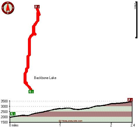
Trailhead 1 to Trailhead 2: Total hiking length = 2.4 miles Total climbing distance = 1.8 miles Difficulty : Difficult Casual Hiking Pace:
2.5 hours
Fast Hiking Pace:
1.5 hours
Trailhead 2 to Trailhead 1: Total hiking length = 2.4 miles Total climbing distance = .1 miles Difficulty : Easy Casual Hiking Pace:
1.5 hours
Fast Hiking Pace:
1 hours
| | Trailhead 1 back to Trailhead 1: Total hiking length = 4.8 miles Total climbing distance = 1.9 miles Difficulty : Medium Casual Hiking Pace:
4 hours
Fast Hiking Pace:
2.5 hours
Trailhead 2 back to Trailhead 2: Total hiking length = 4.8 miles Total climbing distance = 1.9 miles Difficulty : Medium Casual Hiking Pace:
4 hours
Fast Hiking Pace:
2.5 hours
|
Total elevation difference: 1833 feet

Kings Valu Inn, Enumclaw
|
35 miles away
Kings Valu Inn *Free Wireless Internet - Outdoor Seasonal Pool - In-Room Coffee - Quality Rooms* Kings Valu Inn is the complete home away from home for your traveling convenience. Stay for a day, a we...
|
| |
Howard Johnson Snoqualmie/Summit, Snoqualmie Pass
|
37 miles away
On Snoqualmie Pass, The only hotel on the mountain, Outdoor Heated Swimming pool, Indoor Hot Tub and Sauna. Ski across the street - 4 mountains to ski from. Free Shuttle Service to all Base Areas at ...
|
|
User input for Backbone Ridge Trail, Northern Cascade Range, Lewis County, Washington:

Outdoors Recreation Near Hood River, Oregon Very comprehensive list of a variety of outdoors recreation in the vicinity of Hood River, Oregon, the metro area neareast to Backbone Ridge Trail. Find info on campgrounds, hiking trails, ski resorts, lakes, beaches, parks, whitewater and more.
|
Current weather conditions at Backbone Ridge Trail, Northern Cascade Range, Lewis County, Washington

Local climate location: LONGMIRE RAINIER NPS 13 miles away

           
| |
Econo Lodge Buckley, Buckley
|
37 miles away
Mt. Rainier National Park, Puyallup Fairground, Crystal Mountain, White River Amphitheater and King County Fairground are all nearby. All rooms have microwaves, refrigerators, iron and ironing board. ...
|
Salish Lodge And Spa, Snoqualmie
|
43 miles away
Original Snoqualmie Lodge built atop the Falls in 1916 was a logging route stopover famous for its lumberjack breakfast. The original Lodge had only 5 guestrooms. Building on the existing lodge and in...
|
|
More Hotels and Campgrounds Near Backbone Ridge Trail, Northern Cascade Range, Lewis County, Washington
| |
| |
 |
|
| These outdoors activities are available near Backbone Ridge Trail. |
| | Trails Near Backbone Ridge Trail:
 |
Tatoosh Trail, Lewis County
County
, 5 miles away, 16.4 hiking miles, 5829 feet elevation difference |
 |
Packwood Lake Trail, Lewis County
County
, 5 miles away, 11.4 hiking miles, 384 feet elevation difference |
 |
Three Peaks Trail, Lewis County
County
, 5 miles away, 7.6 hiking miles, 1240 feet elevation difference |
 |
Five Thousand Thirty Trail, Lewis County
County
, 6 miles away, 4.2 hiking miles, 897 feet elevation difference |
|
| | Whitewater Near Backbone Ridge Trail:
 |
Cowlitz River - Muddy Fork, Lewis County
County
, 1 miles away, Class V - 5 miles long (to Cowlitz River) |
 |
Ohanepecosh River, Lewis County
County
, 2 miles away, Class V - 4.7 miles long (Ohanepecosh Campground to La Wis Wis Campground) |
 |
Cowlitz River - Clear Fork, Lewis County
County
, 4 miles away, Class V+ - 5 miles long (Lava Creek to La Wis Wis Campground) |
 |
Cowlitz River, Lewis County
County
, 4 miles away, Class II - 7.6 miles long (La Wis Wis Campground to Packwood) |
 |
Summit Creek, Lewis County
County
, 5 miles away, Class V+ - 5 miles long (Soda Springs to Highway 123) |
|
| | Hotels Near Backbone Ridge Trail:
 |
Kings Valu Inn, Enumclaw
, 35 miles away |
 |
Howard Johnson Snoqualmie/Summit, Snoqualmie Pass
, 37 miles away |
 |
Econo Lodge Buckley, Buckley
, 37 miles away |
 |
Salish Lodge And Spa, Snoqualmie
, 43 miles away |
 |
Comfort Suites Hood River, Hood River
, 47 miles away |
|
|
|
 |
|