| |
|
| | Here in the good state of Oregon backcountry backpacking is something that is always fun to do. Tremendous backcountry hiking trails in Oregon are in abundance, and one of those is Windy Pass Way in Douglas County. Put on your backcountry trekking shoes, and hit the great outdoors trail, Windy Pass Way in Douglas County, Oregon is nature at its best. Now this backcountry hiking trail is pretty long, so don't forget to pack enough supplies. Every single Oregon backcountry hiking trail has its own character. The total elevation difference for this great outdoors |
|
hiking trail is 1,518 feet which is an average number. The high level of precipitation makes Windy Pass Way a rather wet location; all through the month of December you get the most rain around here; July is when it's the driest. Outdoors folks generally like this part of Oregon.
| | There are two trailheads to chose from, one in each end which means you have the option of backpacking it one way if you have someone to pick you up at the other end. Some parts of this wilderness hiking trail are much higher up than other parts of the wilderness hiking trail which of course means you need to be prepared for different conditions on different parts of the wilderness hiking trail. At parts of the year this area sees very little rain, so do check for current fire restrictions before you go if you plan to bring a stove or make a camp fire. The | |
|
warmest time of the year brings highs in the 80's to Windy Pass Way while night lows are usually in the 40's. High temperatures through the wintertime are normally in the 40's; through the dark hours in the wintertime at Windy Pass Way temperatures descend to the 20's. Please follow
all local rules about fires and camping. Trekking here in the Central Cascade Range is a fine way to explore these mountains. This is just one of a large number of trails in this neighborhood. You'll must go far from Klamath Falls to get to Windy Pass Way, but it is a brilliant
great outdoors trail. With its 21 miles of walking distance; it's longer than many wilderness hiking trails. This hike should take you about 3 days, so make sure you've got all your overnight gear packed. This hiking and backpacking trail is many miles long having an average number
of uphill miles which makes this trail wonderful for hard core backpackers looking for adventure.
Briefly about the general area: Life's too short to enjoy all the cool things in the Central Cascade Range. Taking a little tour to close by Tandy Bay is a perfect idea,
and a delightful spot like Pumice Flat here at Windy Pass Way is too fine to miss. It's always glorious to stop by Crystal Springs; a quick tour to Warrior Creek is positively a delightful idea. A good location to go to near Windy Pass Way is Emigrant Pass, and don’t forget
to stop by Slim Prairie while you're here at Windy Pass Way. So much cool stuff in the neighborhood of Windy Pass Way, clearly phenomenal. There's so much to do here at Windy Pass Way that you need to camp here for a while, Lake Lucile Campground is a pleasant site for that, and
Windy Pass Way is tremendous enough to spend more than a day at, Shelter Cove Resort is a tremendous local campground. So many fun things in the Central Cascade Range, just impressive. Put some time aside to spend at Lemolo Falls since you're here at Windy Pass Way, and unsurprisingly Bradley Creek flows through this vicinity.
|
|
Location of Trailhead 1: Latitude 43.4327, Longitude -122.1209 - - Directions and Road Map
Location of Trailhead 2: Latitude 43.3709, Longitude -122.1527 - - Directions and Road Map

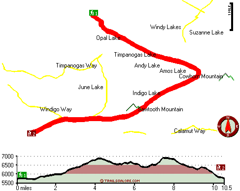
Trailhead 1 to Trailhead 2: Total hiking length = 10.5 miles Total climbing distance = 4.7 miles Difficulty : Difficult Casual Hiking Pace:
1.5 days
Fast Hiking Pace:
5 hours
Trailhead 2 to Trailhead 1: Total hiking length = 10.5 miles Total climbing distance = 5.2 miles Difficulty : Difficult Casual Hiking Pace:
1.5 days
Fast Hiking Pace:
5.5 hours
| | Trailhead 1 back to Trailhead 1: Total hiking length = 21 miles Total climbing distance = 9.9 miles Difficulty : Difficult Casual Hiking Pace:
3 days
Fast Hiking Pace:
2 days
Trailhead 2 back to Trailhead 2: Total hiking length = 21 miles Total climbing distance = 9.9 miles Difficulty : Difficult Casual Hiking Pace:
3 days
Fast Hiking Pace:
2 days
|
Total elevation difference: 1518 feet

Best Western Oakridge Inn, Oakridge
|
32 miles away
This Oakridge, Oregon hotel offers a complimentary continental breakfast each morning and convenient access to a variety of outdoor activities. Discover the Best Western Oakridge Inn, nestled agains...
|
| |
Best Western Newberry Station, La Pine
|
44 miles away
Stay at this La Pine, Oregon hotel, a central location to five of the major recreational areas in Oregon including Crater Lake and the 14 lake Cascade Lakes. Welcome to the Best Western Newberry Sta...
|
|
User input for Windy Pass Way, Central Cascade Range, Douglas County, Oregon:

Outdoors Recreation Near Klamath Falls, Oregon Very comprehensive list of a variety of outdoors recreation in the vicinity of Klamath Falls, Oregon, the metro area neareast to Windy Pass Way. Find info on campgrounds, hiking trails, ski resorts, lakes, beaches, parks, whitewater and more.
More Hotels and Campgrounds Near Windy Pass Way, Central Cascade Range, Douglas County, Oregon
| |
| |
 |
|
| These outdoors activities are available near Windy Pass Way. |
| | Trails Near Windy Pass Way:
 |
Sawtooth Way, Douglas County
County
, 1 miles away, 4.8 hiking miles, 1284 feet elevation difference |
 |
Timpanogas Way, Douglas County
County
, 2 miles away, 4 hiking miles, 432 feet elevation difference |
 |
Windigo Way, Douglas County
County
, 3 miles away, 3.2 hiking miles, 738 feet elevation difference |
 |
Kelsay Way, Douglas County
County
, 3 miles away, 6.2 hiking miles, 2161 feet elevation difference |
 |
Calamut Way, Douglas County
County
, 4 miles away, 2.7 hiking miles, 595 feet elevation difference |
 |
Windy Lakes Trail, Klamath County
County
, 4 miles away, 8 hiking miles, 1381 feet elevation difference |
 |
Fawn Lake Way, Klamath County
County
, 6 miles away, 14 hiking miles, 2081 feet elevation difference |
|
| | Whitewater Near Windy Pass Way:
 |
Hills Creek, Lane County
County
, 21 miles away, Class IV - 6 miles long (6 mi above Reservoir) |
 |
Salt Creek, Lane County
County
, 23 miles away, Class III-IV - 7.2 miles long (McCredie Hot Springs to Rigdon Road Bridge) |
 |
Salmon Creek, Lane County
County
, 27 miles away, Class II-V - 12 miles long (Top of Upper Salmon Creek Gorge to Oakridge) |
 |
Christy Creek, Lane County
County
, 30 miles away, Class III-V(V+) - 9 miles long (to Confluence with Willamette) |
 |
Willamette River - North Fork of Middle Fork, Lane County
County
, 30 miles away, Class IV-V - 13.5 miles long (to Westfir) |
|
|
|
 |
|