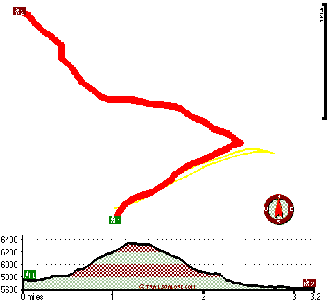
| |
|
| | Every Oregon backpacking and hiking trail has its own unique prettiness. With so many outdoors pursuits available in Oregon you'll never get bored. Windigo Way is a long tour away from Klamath Falls, but there's tremendous natural loveliness right here for you along it. This is a two-ended hiking and backpacking trail with two trailheads, so if you can get a ride from someone, you can backcountry trek it just one way. This backcountry walk shouldn't take more than 5.5 hours, but of course some people walk a bit slower and some a bit faster. Backpacking |
|
and hiking trails are great and plentiful in Oregon; one of them being Windigo Way in Douglas County. Throughout the summer at Windigo Way highs are regularly in the 80's with overnight lows in the 40's. During the winter highs are usually in the 40's, and overnight lows throughout
| | the winter for Windigo Way tend to be in the 20's. This is a neighborhood covered with lots of great outdoors trails. Windigo Way is 6.4 miles long it's a mid length backcountry trek. Put on your backpacking shoes, and hit the backpacking and hiking trail, Windigo Way in Douglas County, Oregon is a really tremendous spot to spend some time. Windigo Way is quite long, so do pack enough food to last the whole trip. Don’t forget to check for any current restrictions or closures before you go. These backpacking trails here in the Central Cascade Range are | |
|
the best way to enjoy these summits. This hiking and backpacking trail has a total elevation difference of 738 feet which is a lower than average number. This region does get very dry sometimes, so make sure you check current conditions and fire restrictions with local forest authorities
before you head out. Windigo Way is a mid-length backpacking trail having an average number of uphill miles which makes it a glorious great outdoors trail for experienced backcountry trekkers in great shape. The high level of rain makes Windigo Way a rather wet site; the month
of December is the wettest with most of the rain, and the driest month is July. Going for a backcountry trek here in Oregon never gets boring. The hiking and backpacking trail stays roughly within the same elevation zone the whole time, so you get pretty much the same conditions
along the whole hiking and backpacking trail.
Briefly about the general area: This location, the Central Cascade Range, has so much outdoors cool stuff. Lake Lucile Campground is a perfect campground here, and you can stay the night at Diamond Lake RV Park.
|
|
Location of Trailhead 1: Latitude 43.3695, Longitude -122.1526 - - Directions and Road Map
Location of Trailhead 2: Latitude 43.3956, Longitude -122.1646 - - Directions and Road Map

Trailhead 1 to Trailhead 2: Total hiking length = 3.2 miles Total climbing distance = 1 miles Difficulty : Easy Casual Hiking Pace:
2.5 hours
Fast Hiking Pace:
1.5 hours
Trailhead 2 to Trailhead 1: Total hiking length = 3.2 miles Total climbing distance = 1.6 miles Difficulty : Medium Casual Hiking Pace:
3 hours
Fast Hiking Pace:
1.5 hours
| | Trailhead 1 back to Trailhead 1: Total hiking length = 6.4 miles Total climbing distance = 2.6 miles Difficulty : Difficult Casual Hiking Pace:
5.5 hours
Fast Hiking Pace:
3.5 hours
Trailhead 2 back to Trailhead 2: Total hiking length = 6.4 miles Total climbing distance = 2.6 miles Difficulty : Difficult Casual Hiking Pace:
5.5 hours
Fast Hiking Pace:
3.5 hours
|
Total elevation difference: 738 feet

Best Western Oakridge Inn, Oakridge
|
30 miles away
This Oakridge, Oregon hotel offers a complimentary continental breakfast each morning and convenient access to a variety of outdoor activities. Discover the Best Western Oakridge Inn, nestled agains...
|
| |
Best Western Newberry Station, La Pine
|
47 miles away
Stay at this La Pine, Oregon hotel, a central location to 5 of the major recreational areas in Oregon including Crater Lake and the 14 lake Cascade Lakes. Welcome to the Best Western Newberry Statio...
|
|
User input for Windigo Way, Central Cascade Range, Douglas County, Oregon:

Outdoors Recreation Near Klamath Falls, Oregon Very comprehensive list of a variety of outdoors recreation in the vicinity of Klamath Falls, Oregon, the metro area neareast to Windigo Way. Find info on campgrounds, hiking trails, ski resorts, lakes, beaches, parks, whitewater and more.
More Hotels and Campgrounds Near Windigo Way, Central Cascade Range, Douglas County, Oregon
| |
| |
 |
|
| These outdoors activities are available near Windigo Way. |
| | Trails Near Windigo Way:
 |
Timpanogas Way, Douglas County
County
, 1 miles away, 4 hiking miles, 432 feet elevation difference |
 |
Sawtooth Way, Douglas County
County
, 1 miles away, 4.8 hiking miles, 1284 feet elevation difference |
 |
Windy Pass Way, Douglas County
County
, 3 miles away, 10.5 hiking miles, 1518 feet elevation difference |
 |
Kelsay Way, Douglas County
County
, 4 miles away, 6.2 hiking miles, 2161 feet elevation difference |
 |
Calamut Way, Douglas County
County
, 6 miles away, 2.7 hiking miles, 595 feet elevation difference |
 |
Windy Lakes Trail, Klamath County
County
, 7 miles away, 8 hiking miles, 1381 feet elevation difference |
 |
McGowan Mountain Way, Douglas County
County
, 8 miles away, 2.9 hiking miles, 2074 feet elevation difference |
|
| | Hotels Near Windigo Way:
 |
Mazama Village Motor Inn, Crater Lake
, 24 miles away |
 |
Crater Lake Motel, Chemult
, 27 miles away |
 |
Chemult Motel, Chemult
, 27 miles away |
 |
Holiday Village Motel Trailer, Chemult
, 27 miles away |
 |
Whispering Pines Motel, Chemult
, 27 miles away |
|
|
|
 |
|