Oregon hiking trails - Williams Creek Trail, Central Cascade Range, Douglas County

   
  Every backcountry hiking trail in Oregon is different from the others. It's a lengthy trip from Eugene-Springfield to Williams Creek Trail, but if you're looking for a great site to go hiking, this is a great pick. Oregon is a brilliant place for backcountry hikers. This is a region covered with lots of backcountry trails. Through the summertime months here at Williams Creek Trail, high temperatures generally get into the 70's. During the moonlight hours it's ordinarily in the 40's. The winter brings highs down to the 40's; overnight lows during the
    winter for Williams Creek Trail tend to be in the 30's. When you're here in Oregon hiking along one of its backcountry hiking trails is a glorious way to spend some time. At parts of the year this region sees very little rain, so do check for current fire restrictions before you
go if you plan to bring a stove or make a camp fire. Alright, enough of spending all this time inside a building, time to get out, and if you happen to be in Douglas County of Oregon, Williams Creek Trail is a great local backpacking trail for doing a bit of leg stretching. Of course, this is an overnight backcountry walk, 1.5 days normally, so better have big backpack to fit all the stuff you need. Williams Creek Trail is a two ended hiking trail with two trailheads which means you have the option of backcountry hiking it one way if you have someone  
to pick you up at the other end. Some parts of Williams Creek Trail are much higher up than other parts of the hiking trail, and that means that some parts of the hiking trail could be very different from other parts of it. 
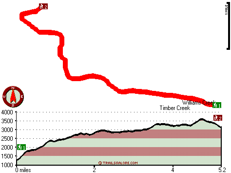
The total elevation difference for this hiking trail is 2,407 feet, and that is about average. Being 10.4 miles long; it's longer than many hiking trails. Great outdoors hiking trails for hiking, and backpacking can be found all over Oregon; Williams Creek Trail in Douglas County is one of them. Hiking trails like this one here in the Central Cascade Range are a really nice way to spend quality time in the fresh air. This hiking trail is a very long hiking trail having an average number of uphill miles which makes it a splendid backcountry trail for experienced walkers in great shape. Williams Creek Trail is a wet location that gets lots of rain; the month with most of the rain is November while July is generally the driest month. Please follow all local rules about fires and camping. This is a long great outdoors hiking trail, so don't forget to pack enough supplies.

Briefly about the general area:
Don't leave Williams Creek Trail without first paying a visit to Winslow Cabin Spring; glide down the rapids of Canyon Creek in a kayak. You definitely should go for the Central Cascade Range.
Whohoo, so many enjoyable things in one place! Williams Creek Trail is so good! Smith Springs Campground is a good local campground, and it's a pleasant idea to visit Bogus Creek. These mountains rock, just look at all the enjoyable stuff to do in the Central Cascade Range. River View RV Park is a splendid campground nearby, and don’t forget to visit Willow Flats since you're here at Williams Creek Trail. Don't forget to take a glorious little spree to Cougar Creek, and get covered with water paddling on Umpqua River - North.
A visit to Little Falls will fill your spirit with great feelings; why not check out Bloody Point also while you're here.

Location of Trailhead 1: Latitude 43.3377, Longitude -122.7662
- - Directions and Road Map

Location of Trailhead 2: Latitude 43.3677, Longitude -122.8192
- - Directions and Road Map


Trailhead 1 to Trailhead 2:
Total hiking length = 5.2 miles
Total climbing distance = 3.1 miles
Difficulty : Medium
Casual Hiking Pace: 5 hours
Fast Hiking Pace: 3 hours

Trailhead 2 to Trailhead 1:
Total hiking length = 5.2 miles
Total climbing distance = 1.4 miles
Difficulty : Easy
Casual Hiking Pace: 4 hours
Fast Hiking Pace: 2 hours
    Trailhead 1 back to Trailhead 1:
Total hiking length = 10.4 miles
Total climbing distance = 4.5 miles
Difficulty : Difficult
Casual Hiking Pace: 1.5 days
Fast Hiking Pace: 6 hours

Trailhead 2 back to Trailhead 2:
Total hiking length = 10.4 miles
Total climbing distance = 4.5 miles
Difficulty : Difficult
Casual Hiking Pace: 1.5 days
Fast Hiking Pace: 6 hours

Total elevation difference: 2407 feet


Moonstone Village Green Resort, Cottage Grove
28 miles away
Village Green Resort is located off Interstate 5, in Cottage Grove. The resort is six miles from the covered bridges, and approximately 30 miles from Eugene Airport. We are less than a mile from two g...
  
Comfort Inn Cottage Grove, Cottage Grove
28 miles away
User input for Williams Creek Trail, Central Cascade Range, Douglas County, Oregon:

Submit Input:
Your Name:
Write or Paste Input here:

Upload picture:      Review Guidelines


Outdoors Recreation Near Eugene-Springfield, Oregon
Very comprehensive list of a variety of outdoors recreation in the vicinity of Eugene-Springfield, Oregon, the metro area neareast to Williams Creek Trail. Find info on campgrounds, hiking trails, ski resorts, lakes, beaches, parks, whitewater and more.

Current weather conditions at Williams Creek Trail, Central Cascade Range, Douglas County, Oregon
WXPort

Local climate location: DORENA DAM 16 miles away

Holiday Inn Express COTTAGE GROVE, Cottage Grove
28 miles away
Welcome to the Holiday Inn Express in Cottage Grove.We are conveniently located in the Willamette Valley 30 miles south of Eugene just off I-5 at exit 174.We offer a free Continental Breakfast, an ind...

Best Western Oakridge Inn, Oakridge
29 miles away
This Oakridge, Oregon hotel offers a complimentary continental breakfast each morning and convenient access to a variety of outdoor activities. Discover the Best Western Oakridge Inn, nestled agains...

More Hotels and Campgrounds Near Williams Creek Trail, Central Cascade Range, Douglas County, Oregon

OTHER_INFO
  Central Cascade Range Campgrounds
Complete list of all the campgrounds in the Central Cascade Range.

Central Cascade Range Outdoors Info
Complete outdoors info for the Central Cascade Range.

Oregon Hiking Trails
Complete list of all hiking trails in Oregon

Books about hiking trails in Oregon
List of books available on Amazon.com about hiking trails in Oregon.

Oregon Outdoors Index
This is a very comprehensive index of outdoors activities in the great state of Oregon.


TOPO
High quality water resistant topo map of Williams Creek Trail, Central Cascade Range, Douglas County, Oregon.

OUTDOORS_GUIDE
These outdoors activities are available near Williams Creek Trail.
 Trails Near Williams Creek Trail:
Mott Trail, Douglas County County , 3 miles away, 7 hiking miles, 3396 feet elevation difference
Panther Trail, Douglas County County , 5 miles away, 9.3 hiking miles, 3150 feet elevation difference
Leach Camp Trail, Douglas County County , 7 miles away, 1.1 hiking miles, 1608 feet elevation difference
Pass Creek Trail, Douglas County County , 7 miles away, 3.9 hiking miles, 1839 feet elevation difference
Francis Way, Lane County County , 9 miles away,  .6 hiking miles, 136 feet elevation difference
China Creek Trail, Lane County County , 10 miles away, 1.5 hiking miles, 992 feet elevation difference
Red Butte Trail, Douglas County County , 10 miles away, 8.6 hiking miles, 1909 feet elevation difference
 Camp Grounds Near Williams Creek Trail:
Smith Springs Campground, Douglas County, 9 miles away
River View RV Park, Idleyld Park, 14 miles away
Shadow Falls Campground, Douglas County, 14 miles away
Buckhead Mountain Campground, Douglas County, 15 miles away
Umpqua's Last Resort Wilderness RV Park, Idleyld Park, 15 miles away
 Whitewater Near Williams Creek Trail:
Umpqua River - North, Douglas County County , 4 miles away, Class III - 25.5 miles long (Soda Springs to Deadline Falls)
Canyon Creek, Douglas County County , 4 miles away, Class III-IV - 9 miles long (Confluence with Pass Creek to Steamboat Creek)
Little River, Douglas County County , 6 miles away, Class -blank- - 8 miles long (FS Road 165 to White Creek Campground)
Steamboat Creek, Douglas County County , 7 miles away, Class IV - 6 miles long (Steamboat Falls to Canton Creek Campground)
Steamboat Creek, Douglas County County , 10 miles away, Class II+(IV) - 9.5 miles long (City Creek to Steamboat Falls)
 National Parks Near Williams Creek Trail:
Crater Lake National Park, Crater Lake - OR , 51 miles away
 Hotels Near Williams Creek Trail:
Moonstone Village Green Resort, Cottage Grove , 28 miles away
Comfort Inn Cottage Grove, Cottage Grove , 28 miles away
Holiday Inn Express COTTAGE GROVE, Cottage Grove , 28 miles away
Best Western Oakridge Inn, Oakridge , 29 miles away
Comfort Inn & Suites Creswell, Creswell , 32 miles away

Outdoors related information copyright © Stratus-Pikpuk, Inc. - Detailed hotel information copyright © Interactive Hotel Solutions