Oregon hiking trails - Wickiup Trail, Southern Cascade Range, Klamath County

   
  Great outdoors trails are magnificent and plentiful in Oregon, and one of these is Wickiup Trail in Klamath County. Alright, enough of spending all this time inside a building, time to get out, and Wickiup Trail in Klamath County, Oregon is the great outdoors at its best. Wickiup Trail is located a pretty long drive from Klamath Falls, but trekking it is always enjoyable. Some parts of Wickiup Trail are much higher up than other parts of the backcountry trail, and that means that some parts of the backcountry trail could be very different from other parts
    of it. This hiking trail has only one trailhead, so you're looking at an in and out backcountry hike. Of course, this is an overnight backcountry hike, 2 days normally, so better have big backpack to fit all the stuff you need. While visiting this neighborhood in Oregon it's a
great idea to go backcountry hiking too. Wickiup Trail is quite long, so don't forget to pack enough supplies. Every Oregon wilderness hiking trail is stunning in its own way. Being 12.4 miles long; it's longer than many backcountry trails. Wickiup Trail is a fine location of typical rain; through the month of November you get the most rain around here; the driest of the months is July. This trail sometimes gets very dry, so don’t forget to check for any current fire restrictions before you go. This backpacking and hiking trail is a very long backpacking and  
hiking trail having an average number of uphill miles which makes this a very tough backpacking trail for advanced hikers looking for a fine challenge. For the period of the months of summer highs here at Wickiup Trail get into the 80's. Summer overnight lows drop down to the 40's. The wintertime brings highs down to the 40's, and after the sun is down through the wintertime temperatures at Wickiup Trail drop into the 20's. Backcountry trails like this one here in the Southern Cascade Range are a really splendid way to spend quality time in the great outdoors. Please follow all local rules about fires and camping. Going for a walk here in Oregon never gets boring. Wickiup Trail has a total elevation difference of 2,089 feet which is an average number. There are so many backpacking trails in this vicinity.

Briefly about the general area:
But wait, there's more cool stuff to do in the Southern Cascade Range. Don’t forget to have a look at Wickiup Meadow if you're here at Wickiup Trail, and Crater Lake National Park is a great local destination.
Getting to Little Butte Creek from Wickiup Trail is uncomplicated; why not camp at Upper South Fork Campground if you're here at Wickiup Trail. This river is always fun. Wickiup Spring is a beautiful spot to pop by while you're at Wickiup Trail, and some of the water nearby flows, like Little Billie Creek. Having a great time in the Southern Cascade Range is painless. Onion Spring is always fun to check out, and a tremendous spot to camp here at Wickiup Trail is Hemlock Lake Campground.
You'll wish for more hours in a day to enjoy all the enjoyable things at Wickiup Trail. Soar down the rapids of Rogue River - North Fork in a kayak, and you should without doubt dedicate some time to Seven Lakes Basin if you're here at Wickiup Trail.

Location of Trailhead: Latitude 42.6059, Longitude -122.2983
- - Directions and Road Map

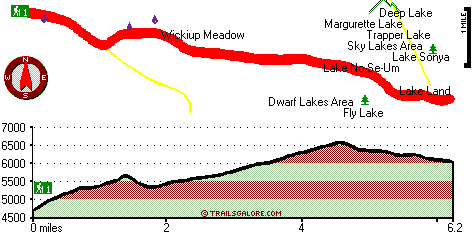
Total in and out hiking length = 12.4 miles

Total climbing distance = 5.5 miles

Difficulty : Difficult

Casual Hiking Pace: 2 days

Fast Hiking Pace: 7.5 hours

Total elevation difference: 2089 feet


Running Y Ranch, Klamath Falls
30 miles away
  
Lithia Springs Resort And Gardens, Ashland
30 miles away
Hello, from Ashland, Oregon! Imagine, at the end of a long day's travel, relaxing in a 2 person whirlpool filled with hot mineral water, right in your own room. Lay back, Let the relaxing quality of t...
User input for Wickiup Trail, Southern Cascade Range, Klamath County, Oregon:

Submit Input:
Your Name:
Write or Paste Input here:

Upload picture:      Review Guidelines


Outdoors Recreation Near Klamath Falls, Oregon
Very comprehensive list of a variety of outdoors recreation in the vicinity of Klamath Falls, Oregon, the metro area neareast to Wickiup Trail. Find info on campgrounds, hiking trails, ski resorts, lakes, beaches, parks, whitewater and more.

Current weather conditions at Wickiup Trail, Southern Cascade Range, Klamath County, Oregon
WXPort

Local climate location: PROSPECT 8 miles away

Klamath Falls Super 8 Motel, Klamath Falls
35 miles away
AAA approved. Conveniently located on Hwy 97, near Hwy 140, and Hwy 66. Downtown just minutes away. Klamath Medical Center Oregon Institute of Technology, State and National Forestry offices nearby. L...

Windmill Inn And Suites Of Ashland, Ashland
36 miles away
Discover one of the Northwests most luxurious inns. Escape civilizations cares without leaving its pleasures behind. Come and enjoy the quiet side of Ashland. All suite hotel with magnificent panora...

More Hotels and Campgrounds Near Wickiup Trail, Southern Cascade Range, Klamath County, Oregon

OTHER_INFO
  Southern Cascade Range Campgrounds
Complete list of all the campgrounds in the Southern Cascade Range.

Southern Cascade Range Outdoors Info
Complete outdoors info for the Southern Cascade Range.

Oregon Hiking Trails
Complete list of all hiking trails in Oregon

Books about hiking trails in Oregon
List of books available on Amazon.com about hiking trails in Oregon.

Oregon Outdoors Index
This is a very comprehensive index of outdoors activities in the great state of Oregon.


TOPO
High quality water resistant topo map of Wickiup Trail, Southern Cascade Range, Klamath County, Oregon.

OUTDOORS_GUIDE
These outdoors activities are available near Wickiup Trail.
 Trails Near Wickiup Trail:
Red Lake Trail, Klamath County County , 2 miles away, 10.3 hiking miles, 1759 feet elevation difference
Hemlock Lake Trail, Klamath County County , 3 miles away,  10.4 hiking miles, 2410 feet elevation difference
Seven Lakes Trail, Jackson County County , 3 miles away,  8.4 hiking miles, 2741 feet elevation difference
South Fork Trail, Klamath County County , 4 miles away, 7.4 hiking miles, 1813 feet elevation difference
King Spruce Trail, Klamath County County , 4 miles away,  5.6 hiking miles, 974 feet elevation difference
Blue Canyon Trail, Klamath County County , 4 miles away,  10 hiking miles, 763 feet elevation difference
Cold Spring Trail, Klamath County County , 5 miles away, 6.5 hiking miles, 937 feet elevation difference
 Camp Grounds Near Wickiup Trail:
Hemlock Lake Campground, Klamath County, 2 miles away
Upper South Fork Campground, Jackson County, 4 miles away
Saddle Campground, Jackson County, 5 miles away
Sevenmile Marsh Campground, Klamath County, 9 miles away
White Pine Campground, Klamath County, 11 miles away
 Whitewater Near Wickiup Trail:
Rogue River - North Fork, Jackson County County , 20 miles away, Class III - 6 miles long (River Bridge to North Fork Park)
Rogue River - North Fork, Jackson County County , 20 miles away, Class IV(V+) - 3.3 miles long (Mill Creek Falls to Lost Creek Lake)
Rogue River - North Fork, Jackson County County , 22 miles away, Class IV - 3 miles long (Natural Bridge to Woodruff Bridge)
Big Butte Creek, Jackson County County , 26 miles away, Class III-IV - 9.5 miles long (Butte Falls to Netherlands Road)
 National Parks Near Wickiup Trail:
Crater Lake National Park, Crater Lake - OR , 18 miles away
Lava Beds National Monument, Tulelake - CA , 63 miles away
 Hotels Near Wickiup Trail:
Rocky Point Station Lodging, Klamath Falls , 13 miles away
Mazama Village Motor Inn, Crater Lake , 17 miles away
Aspen Inn Motel, Fort Klamath , 18 miles away
Ft. Klamath Lodge & Rv, Fort Klamath , 18 miles away
Wilson's Cottages, Fort Klamath , 18 miles away
 Lakes Near Wickiup Trail
Holst Lake, Klamath County , 1 miles away
Hemlock Lake, Klamath County , 2 miles away

Outdoors related information copyright © Stratus-Pikpuk, Inc. - Detailed hotel information copyright © Interactive Hotel Solutions