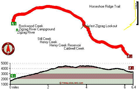
Oregon hiking trails - West Zigzag Mountain Trail, Central Cascade Range, Clackamas County

   
  Oregon has so much to offer nature lovers. Hitting the wilderness hiking trails is always an exciting thing to do, and West Zigzag Mountain Trail in Clackamas County, Oregon is an excellent site to go. There are plenty of hiking and backpacking trails in Oregon; each one of them has something unique to offer. West Zigzag Mountain Trail is a long journey away from Hood River, but It's always exciting to backcountry hike here. This is a long trail, so do pack enough food to last the whole trip. Being 12.8 miles long; it's longer than many great outdoors
    hiking trails. West Zigzag Mountain Trail sees pretty high levels of rain; the month with most of the rain is December while July is generally the driest month. Through the summertime, highs frequently are in the 70's at West Zigzag Mountain Trail; through summer nights temperatures
are in the 50's. Daytime highs through the wintertime are in the 40's; after the sun is down through the wintertime temperatures at West Zigzag Mountain Trail descend into the 30's. Some parts of this great outdoors hiking trail are much higher up than other parts of the great outdoors hiking trail, so keep in mind that you may need to dress differently at different elevations. The picturesque backcountry hiking trails of the Central Cascade Range are a really magnificent way to spend quality time in nature. The total elevation difference for this wilderness  
hiking trail is 3,016 feet which is a higher than average number. West Zigzag Mountain Trail is a two ended wilderness hiking trail with two trailheads, so if you can get a ride from someone, you can backcountry hike it just one way. West Zigzag Mountain Trail is many miles long having an average number of uphill miles which makes this hiking trail pleasant for hard core backpackers looking for adventure. This is a region covered with lots of hiking trails. Now, this is roughly a 2-day backcountry walk, so make sure you've got all your overnight gear packed. Hiking in Oregon is always an enjoyable thing to do. And keep in mind that there could be temporary safety restrictions in spot. Oregon has plenty of glorious hiking and backpacking trails; West Zigzag Mountain Trail in Clackamas County is one of them.

Briefly about the general area:
Now, you may assume that's plenty but there's even more amusing stuff to do here at West Zigzag Mountain Trail. Henry Creek flows through this region; Pioneer Tollgate Campground is a splendid local campground. Devil Canyon is a wonderful place to go to right next door to West Zigzag Mountain Trail; Old Maid Flat is a perfect location to check out.
A visit to Wind Creek Basin revitalizes the soul, and you can run the rapids of Zigzag River. Not enough hours in a day to enjoy the Central Cascade Range. A quick trip to Caldwell Creek in the vicinity of West Zigzag Mountain Trail is a great idea. But wait, there's more entertaining things to do in the Central Cascade Range. West Zigzag Mountain Trail is a perfect place to visit for more than one day, Bighorn Campground is a perfect place to camp nearby, and Final Falls is a lovely place to stop by while you're at West Zigzag Mountain Trail.
A short journey to Frustration Falls is always worthwhile, and get your pulse rate up on the nice whitewater of Sandy River.

Location of Trailhead 1: Latitude 45.3444, Longitude -121.928
- - Directions and Road Map

Location of Trailhead 2: Latitude 45.3242, Longitude -121.8566
- - Directions and Road Map


Trailhead 1 to Trailhead 2:
Total hiking length = 6.4 miles
Total climbing distance = 3.7 miles
Difficulty : Difficult
Casual Hiking Pace: 6.5 hours
Fast Hiking Pace: 3.5 hours

Trailhead 2 to Trailhead 1:
Total hiking length = 6.4 miles
Total climbing distance = 2.3 miles
Difficulty : Difficult
Casual Hiking Pace: 5.5 hours
Fast Hiking Pace: 3 hours
    Trailhead 1 back to Trailhead 1:
Total hiking length = 12.8 miles
Total climbing distance = 6 miles
Difficulty : Difficult
Casual Hiking Pace: 2 days
Fast Hiking Pace: 7.5 hours

Trailhead 2 back to Trailhead 2:
Total hiking length = 12.8 miles
Total climbing distance = 6 miles
Difficulty : Difficult
Casual Hiking Pace: 2 days
Fast Hiking Pace: 7.5 hours

Total elevation difference: 3016 feet


Whispering Woods (Vri), Welches
5 miles away
Whispering Woods is a resort destination east of Portland which opened in 1981 with 42 condominiums. The second phase of 24 additional condominiums opened in 1992. The resort offers a clubhouse with a...
  
Resort at the Mountain, Welches
5 miles away
The Resort at The Mountain is the premier Northwest golf and ski resort located in the Highlands of Oregon just an hour east of Portland at the western base of Mt. Hood. The Resort features 160 gues...
User input for West Zigzag Mountain Trail, Central Cascade Range, Clackamas County, Oregon:

Submit Input:
Your Name:
Write or Paste Input here:

Upload picture:      Review Guidelines


Outdoors Recreation Near Hood River, Oregon
Very comprehensive list of a variety of outdoors recreation in the vicinity of Hood River, Oregon, the metro area neareast to West Zigzag Mountain Trail. Find info on campgrounds, hiking trails, ski resorts, lakes, beaches, parks, whitewater and more.

Current weather conditions at West Zigzag Mountain Trail, Central Cascade Range, Clackamas County, Oregon
WXPort

Local climate location: HEADWORKS PTLD WTR BUR 13 miles away

Mount Hood Inn, Government Camp
9 miles away
At the Mount Hood Inn we offer our guests the finest accommodations on the mountain. With our modern facilities and friendly local staff we are able to give you the attention and service you have com...

Bonneville Hot Springs Resort, North Bonneville
15 miles away
This property is a 100 percent nonsmoking facility. Up to two children 16 and under stay free in same room with adult. Over two children are 10.00USD per child per day and purchase of rollaway is requ...

More Hotels and Campgrounds Near West Zigzag Mountain Trail, Central Cascade Range, Clackamas County, Oregon

OTHER_INFO
  Central Cascade Range Campgrounds
Complete list of all the campgrounds in the Central Cascade Range.

Central Cascade Range Outdoors Info
Complete outdoors info for the Central Cascade Range.

Oregon Hiking Trails
Complete list of all hiking trails in Oregon

Books about hiking trails in Oregon
List of books available on Amazon.com about hiking trails in Oregon.

Oregon Outdoors Index
This is a very comprehensive index of outdoors activities in the great state of Oregon.


TOPO
High quality water resistant topo map of West Zigzag Mountain Trail, Central Cascade Range, Clackamas County, Oregon.

OUTDOORS_GUIDE
These outdoors activities are available near West Zigzag Mountain Trail.
 Trails Near West Zigzag Mountain Trail:
Flag Mountain Trail, Clackamas County County , 1 miles away, 1.6 hiking miles, 924 feet elevation difference
Horseshoe Ridge Trail, Clackamas County County , 3 miles away,  6.6 hiking miles, 2174 feet elevation difference
Still Creek Trail, Clackamas County County , 3 miles away, 1.6 hiking miles, 274 feet elevation difference
Cool Creek Trail, Clackamas County County , 3 miles away, 4.3 hiking miles, 3377 feet elevation difference
Cast Creek Trail, Clackamas County County , 4 miles away, 4 hiking miles, 2784 feet elevation difference
Devils Canyon Trail, Clackamas County County , 4 miles away, 5.5 hiking miles, 1797 feet elevation difference
Hambone Trail, Clackamas County County , 4 miles away, 7.2 hiking miles, 1286 feet elevation difference
 Camp Grounds Near West Zigzag Mountain Trail:
Pioneer Tollgate Campground, Clackamas County, 1 miles away
Bighorn Campground, Clackamas County, 4 miles away
Devils Meadow Campground, Clackamas County, 4 miles away
Kinzel Lake Campground, Clackamas County, 5 miles away
Twin Bridges Campground, Clackamas County, 6 miles away
 Whitewater Near West Zigzag Mountain Trail:
Sandy River, Clackamas County County , 2 miles away, Class IV - 4.5 miles long (McNeil Campground to Lolo Pass Road)
Zigzag River, Clackamas County County , 2 miles away, Class III-IV - 3.2 miles long (Tollgate to Sandy River)
Sandy River, Clackamas County County , 10 miles away, Class II-III - 13.5 miles long (Lolo Pass Road to Marmot Dam)
Little Sandy River, Clackamas County County , 12 miles away, Class -blank- - 10 miles long (Bridge on FS 14 to SE Marmot Road)
Hood River - Lake Branch, Hood River County County , 15 miles away, Class IV-V - 3 miles long (3 miles above West Fork to Confluence with West Fork)
 National Parks Near West Zigzag Mountain Trail:
Mount Rainier National Park, Ashford - WA , 68 miles away
 Hotels Near West Zigzag Mountain Trail:
Whispering Woods (Vri), Welches , 5 miles away
Resort at the Mountain, Welches , 5 miles away
Mount Hood Inn, Government Camp , 9 miles away
Bonneville Hot Springs Resort, North Bonneville , 15 miles away
Best Western Columbia River Inn, Cascade Locks , 16 miles away

Outdoors related information copyright © Stratus-Pikpuk, Inc. - Detailed hotel information copyright © Interactive Hotel Solutions