| |
|
| | There are numerous backpacking trails in Oregon, and each one is beautiful in its own way. With so many outdoors pastimes available in Oregon you'll never get bored. Time to get out, and breathe some fresh air, and Wagner Gulch Trail in Grant County, Oregon is just the place. Wagner Gulch Trail has a total elevation difference of 2,158 feet which is about average. Through the warm days of summer here at Wagner Gulch Trail, high temperatures usually reach the 80's. Through the dark hours of summer temperatures fall down into the 30's. Through the wintertime |
|
highs are ordinarily in the 30's while Wagner Gulch Trail night low temperatures through the wintertime are in the 10's. Wagner Gulch Trail is located a relatively long trip from La Grande, but it's one of those places where backpacking is great. This is a long backcountry trail,
| | so make sure you bring plenty of supplies. Wagner Gulch Trail is 11.2 miles long; it's considered a longer hike. If you happen to be in Oregon, why not go trekking, it is always a fun thing to do. This great outdoors trail is many miles long with an average amount of climbing distance which makes this a very tough backpacking trail for advanced walkers looking for a nice challenge. Some parts of Wagner Gulch Trail are much higher up than other parts of the hiking and backpacking trail, so keep in mind that you may need to dress differently at different elevations. | |
|
This is just one of a large number of backpacking trails in this region. This backcountry trail sometimes gets very dry, so make sure you check current conditions and fire restrictions with local forest authorities before you head out. This hiking trail has two trailheads which
means you have the option of backcountry trekking it one way if you have someone to pick you up at the other end. Oregon has plenty of great backpacking trails, and Wagner Gulch Trail in Grant County is one of them. Wagner Gulch Trail is pretty waterless usually; the wettest month
of the year is usually November, that's the one that rains the most while July is the month with the least amount of precipitation. The great outdoors trails of the Blue Mountains are the best way to enjoy these mountains. This backcountry hike should take you about 1.5 days, so
make sure you've got all your overnight gear packed. And keep in mind that there could be temporary safety restrictions in location.
Briefly about the general area: Places like China Meadow are delightful to go to; in the event that you don't mind getting drenched, you
can always go whitewater paddling on John Day River - North Fork. So many cool things to do here in the Blue Mountains, too nice to be true. There's some flowing water nearby, Crane Creek is a stream you can explore while here, and whitewater paddling is wonderful on Grande Ronde
River. There's just no way someone can get bored here at Wagner Gulch Trail. A trip to Snowshoe Spring will fill your spirit with splendid feelings, and camping at Deerhorn Campground is always a great experience. All year is a great time in the Blue Mountains if you love the
outdoors. The beauty of mother nature reveals herself at Packsaddle Spring. Moon Meadow is a glorious place, and Wagner Gulch Trail is wonderful enough to spend more than a day at, Corrigal Spring Campground is a wonderful local campground. Badger Creek is near Wagner Gulch Trail and is always a delight to explore, and you could always look at McCarty Gulch.
|
|
Location of Trailhead 1: Latitude 44.9351, Longitude -118.5471 - - Directions and Road Map
Location of Trailhead 2: Latitude 44.894, Longitude -118.4812 - - Directions and Road Map

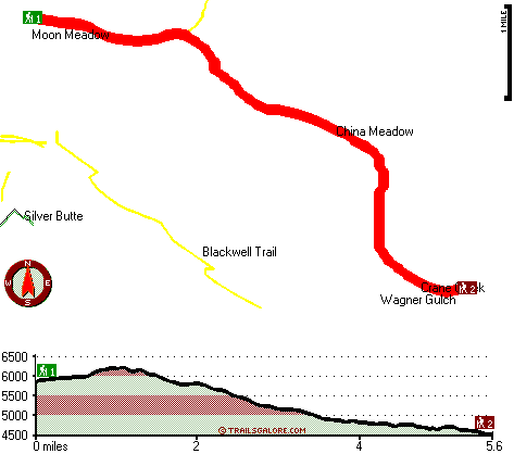
Trailhead 1 to Trailhead 2: Total hiking length = 5.6 miles Total climbing distance = 1.3 miles Difficulty : Easy Casual Hiking Pace:
4.5 hours
Fast Hiking Pace:
2.5 hours
Trailhead 2 to Trailhead 1: Total hiking length = 5.6 miles Total climbing distance = 3.4 miles Difficulty : Medium Casual Hiking Pace:
5.5 hours
Fast Hiking Pace:
3 hours
| | Trailhead 1 back to Trailhead 1: Total hiking length = 11.2 miles Total climbing distance = 4.7 miles Difficulty : Difficult Casual Hiking Pace:
1.5 days
Fast Hiking Pace:
6.5 hours
Trailhead 2 back to Trailhead 2: Total hiking length = 11.2 miles Total climbing distance = 4.7 miles Difficulty : Difficult Casual Hiking Pace:
1.5 days
Fast Hiking Pace:
6.5 hours
|
Total elevation difference: 2158 feet

La Grande Travelodge, La Grande
|
36 miles away
Free Wireless Internet Located in the Heart of La Grande Guests receive 10 percent off at 5 nearby restaurants Free Continental Breakfast Cookies in the afternoon Refrigerator, Coffee Pots, Microwave...
|
| |
Lagrande Super 8 Motel, La Grande
|
37 miles away
Welcome to the Super 8 LaGrange. Our property is AAA Approved, we offer our guests a SuperStart breakfast, indoor heated pool and hot tub, high speed internet, cable TV w/HBO, ESPN, in-room coffee ma...
|
|
User input for Wagner Gulch Trail, Blue Mountains, Grant County, Oregon:

Outdoors Recreation Near La Grande, Oregon Very comprehensive list of a variety of outdoors recreation in the vicinity of La Grande, Oregon, the metro area neareast to Wagner Gulch Trail. Find info on campgrounds, hiking trails, ski resorts, lakes, beaches, parks, whitewater and more.
More Hotels and Campgrounds Near Wagner Gulch Trail, Blue Mountains, Grant County, Oregon
| |
| |
 |
|
| These outdoors activities are available near Wagner Gulch Trail. |
| | Trails Near Wagner Gulch Trail:
 |
Blackwell Trail, Grant County
County
, 1 miles away, 7.6 hiking miles, 2286 feet elevation difference |
 |
Trout Meadows Trail, Grant County
County
, 2 miles away, 3.7 hiking miles, 508 feet elevation difference |
 |
Martin Creek Trail, Grant County
County
, 3 miles away, 4.4 hiking miles, 902 feet elevation difference |
 |
Silver Butte Trail, Grant County
County
, 3 miles away, 7.8 hiking miles, 2246 feet elevation difference |
 |
Indian Trail, Grant County
County
, 4 miles away, 6.7 hiking miles, 1314 feet elevation difference |
 |
Paradise Trail, Grant County
County
, 4 miles away, 8.6 hiking miles, 2883 feet elevation difference |
 |
Lake Creek Trail, Grant County
County
, 6 miles away, 8.7 hiking miles, 2647 feet elevation difference |
|
| | Whitewater Near Wagner Gulch Trail:
 |
John Day River - North Fork, Grant/ Umatilla County
County
, 11 miles away, Class II-III - 41 miles long (Route 52 Bridge to Dale) |
 |
Grande Ronde River, Union County
County
, 17 miles away, Class II-IV - 17 miles long (Tony Vey Meadow to Red Bridge State Park) |
|
| | Hotels Near Wagner Gulch Trail:
 |
La Grande Travelodge, La Grande
, 36 miles away |
 |
Lagrande Super 8 Motel, La Grande
, 37 miles away |
 |
Best Western Rama Inn & Suites, La Grande
, 37 miles away |
 |
Rugged Country Lodge DBA Double H Investments, Pendleton
, 37 miles away |
 |
Best Western John Day Inn, John Day
, 39 miles away |
|
|
|
 |
|