Oregon hiking trails - Union Creek Trail, Southern Cascade Range, Jackson County

   
  No chance of getting bored in Oregon if you like the fresh air. If you happen to be in Oregon, why not go trekking, it is always a fun thing to do. Great backpacking and hiking trails in Oregon are in abundance, and among these are Union Creek Trail in Jackson County. Backcountry trails like this one here in the Southern Cascade Range are the best way to enjoy these peaks. This is a one trailhead backpacking trail, so you'll be backpacking it in and back out. There are numerous backpacking and hiking trails in Oregon, and each one has its own character.
    The total elevation difference for this backpacking trail is 412 feet which is lower than average. This is a region covered with lots of great outdoors hiking trails. The time needed for this backcountry walk is roughly 6 hours, but you never know stuff could go wrong and you could
get stuck so be prepared for that. You spend the whole walk in roughly the same elevation zone which means the conditions are about the same from start to finish. Summertime brings highs in the 80's to Union Creek Trail, and the night is a tad colder of course, frequently in the 40's. All through the winter highs are in the 40's, and after the sun is down during the winter temperatures at Union Creek Trail plunge into the 20's. Union Creek Trail is 7 miles long it's an average length backpacking trail. Union Creek Trail is a mid-length backcountry hiking  
trail with an average amount of climbing distance which makes it a perfect great outdoors hiking trail for experienced backcountry walkers in pleasant shape. At parts of the year this vicinity sees very little rain, so do check for current fire restrictions before you go if you plan to bring a stove or make a camp fire. Union Creek Trail is a backcountry hiking trail quite far from Medford, but when you spend some time backpacking here you will feel like a whole new person. Can’t wait to get out in nature, Union Creek Trail in Jackson County, Oregon is a great spot for getting out. Please follow all local rules about fires and camping. Union Creek Trail is a wet place that gets a great deal of precipitation; November is the month that gets the most rain, and the driest of the months is July. Now this trail is pretty long, so don't forget to pack enough supplies.

Briefly about the general area:
Some of the water close by flows, like Bybee Creek, and Rogue River - North Fork is a nice whitewater spot nearby. The sights at Crater Lake National Park will blow your mind.
This place, the Southern Cascade Range, has so much outdoors fun stuff. Why not camp at Haymaker Campground if you're here at Union Creek Trail, and a fine place for whitewater paddling is Rogue River - North Fork. Mountain Home Mobile Village is a nice local campground, and getting to Castle Creek from Union Creek Trail is easy.

Location of Trailhead: Latitude 42.9068, Longitude -122.4441
- - Directions and Road Map

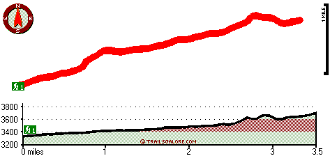
Total in and out hiking length = 7 miles

Total climbing distance = 2.9 miles

Difficulty : Difficult

Casual Hiking Pace: 6 hours

Fast Hiking Pace: 4 hours

Total elevation difference: 412 feet


Lithia Springs Resort And Gardens, Ashland
38 miles away
Hello, from Ashland, Oregon Imagine, at the end of a long day's travel, relaxing in a 2 person whirlpool tub filled with hot mineral water, right in your own room. Let the relaxing quality of the min...
  
La Quinta Inn and Suites White City, White City
39 miles away
The new La Quinta Inn & Suites White City, near Medford, the gateway to Crater Lake National Park, provides spacious, modern rooms with amenities that include microwave, refrigerator, free high-speed ...
User input for Union Creek Trail, Southern Cascade Range, Jackson County, Oregon:

Submit Input:
Your Name:
Write or Paste Input here:

Upload picture:      Review Guidelines


Outdoors Recreation Near Medford, Oregon
Very comprehensive list of a variety of outdoors recreation in the vicinity of Medford, Oregon, the metro area neareast to Union Creek Trail. Find info on campgrounds, hiking trails, ski resorts, lakes, beaches, parks, whitewater and more.

Current weather conditions at Union Creek Trail, Southern Cascade Range, Jackson County, Oregon
WXPort

Local climate location: TOKETEE FALLS 16 miles away

Windmill Inn And Suites Of Ashland, Ashland
41 miles away
Discover one of the Northwests most luxurious inns. Escape civilizations cares without leaving its pleasures behind. Come and enjoy the quiet side of Ashland. All suite hotel with magnificent panora...

Holiday Inn Express Hotel & Suites ASHLAND, Ashland
41 miles away
The Holiday Inn Express Hotel & Suites in Ashland is the gateway to your Oregon adventure. Our hotel features a warm, elegant environment. Conveniently placed near all of Ashland's attractions includi...

More Hotels and Campgrounds Near Union Creek Trail, Southern Cascade Range, Jackson County, Oregon

OTHER_INFO
  Southern Cascade Range Campgrounds
Complete list of all the campgrounds in the Southern Cascade Range.

Southern Cascade Range Outdoors Info
Complete outdoors info for the Southern Cascade Range.

Oregon Hiking Trails
Complete list of all hiking trails in Oregon

Books about hiking trails in Oregon
List of books available on Amazon.com about hiking trails in Oregon.

Oregon Outdoors Index
This is a very comprehensive index of outdoors activities in the great state of Oregon.


TOPO
High quality water resistant topo map of Union Creek Trail, Southern Cascade Range, Jackson County, Oregon.

OUTDOORS_GUIDE
These outdoors activities are available near Union Creek Trail.
 Trails Near Union Creek Trail:
Flat Creek Trail, Jackson County County , 3 miles away, 2.5 hiking miles, 229 feet elevation difference
Anderson Mountain Trail, Douglas County County , 4 miles away,  6.8 hiking miles, 1906 feet elevation difference
Mill Creek Trail, Jackson County County , 4 miles away,  6 hiking miles, 972 feet elevation difference
Dead Soldier Trail, Jackson County County , 5 miles away, 3.1 hiking miles, 1743 feet elevation difference
Sandstone Trail, Douglas County County , 6 miles away, 3.9 hiking miles, 2406 feet elevation difference
Frenchman Camp Trail, Jackson County County , 6 miles away, 1.2 hiking miles, 141 feet elevation difference
Ginkgo Trail, Jackson County County , 6 miles away, 4.7 hiking miles, 1087 feet elevation difference
 Camp Grounds Near Union Creek Trail:
Haymaker Campground, Douglas County, 9 miles away
Mountain Home Mobile Village, Prospect, 9 miles away
Prospect Rv Park, Prospect, 10 miles away
Buckeye Lake Campground, Douglas County, 11 miles away
Cliff Lake Campground, Douglas County, 11 miles away
 Whitewater Near Union Creek Trail:
Rogue River - North Fork, Jackson County County , 5 miles away, Class IV - 3 miles long (Natural Bridge to Woodruff Bridge)
Rogue River - North Fork, Jackson County County , 8 miles away, Class III - 6 miles long (River Bridge to North Fork Park)
Rogue River - North Fork, Jackson County County , 12 miles away, Class IV(V+) - 3.3 miles long (Mill Creek Falls to Lost Creek Lake)
Jackson Creek, Douglas County County , 15 miles away, Class IV(V) - 8 miles long (NF300 to Cover Camp)
 National Parks Near Union Creek Trail:
Crater Lake National Park, Crater Lake - OR , 20 miles away
 Hotels Near Union Creek Trail:
Lithia Springs Resort And Gardens, Ashland , 38 miles away
La Quinta Inn and Suites White City, White City , 39 miles away
Windmill Inn And Suites Of Ashland, Ashland , 41 miles away
Holiday Inn Express Hotel & Suites ASHLAND, Ashland , 41 miles away
Super 8 Ashland, Ashland , 41 miles away

Outdoors related information copyright © Stratus-Pikpuk, Inc. - Detailed hotel information copyright © Interactive Hotel Solutions