| |
|
| | It's a long journey from Medford to Umpqua Rogue Trail, but trekking along this wilderness hiking trail is very exciting. Hiking in Oregon is a splendid idea. Finally, trekking time is here again, and Umpqua Rogue Trail in Douglas County, Oregon is a really tremendous place to spend some time. Umpqua Rogue Trail typically gets a great deal of precipitation; during the month of November you get the most rain around here while July is ordinarily the driest month. This is a vicinity covered with lots of backpacking and hiking trails. Don’t forget to check |
|
for any current restrictions or closures before you go. Through the months of summer here at Umpqua Rogue Trail, high temperatures usually get into the 80's, and the night is slightly cooler of course, typically in the 40's. Highs through the winter are typically in the 40's, and
| | through the dark hours in the winter at Umpqua Rogue Trail temperatures descend to the 30's. With its 7.2 miles of walking distance it's an average length trail. At parts of the year this neighborhood sees very little rain, so make sure you check current conditions and fire restrictions with local forest authorities before you head out. Keep in mind that this is a long backcountry hiking trail, so make sure you bring plenty of supplies. The total elevation difference for Umpqua Rogue Trail is 1,122 feet, and that is about average. Oregon has plenty of great backpacking | |
|
and hiking trails; Umpqua Rogue Trail is one of them, and it's in Douglas County. Umpqua Rogue Trail is a two ended wilderness trail with two trailheads, so if you can get a ride from someone, you can backcountry hike it just one way. There's not much difference in elevation along
Umpqua Rogue Trail, so you get pretty much the same conditions along the whole trail. Each backpacking and hiking trail in Oregon has its own character. The time needed for this backcountry trek is roughly 6.5 hours, but you never know stuff could go wrong and you could get stuck
so be prepared for that. In Oregon you never run out of outdoors fun. Umpqua Rogue Trail is a mid-length backpacking trail having an average number of uphill miles which makes it a nice backpacking and hiking trail for experienced walkers in wonderful shape. The backpacking trails
of the Southern Cascade Range are a very tremendous way to see these mountains.
Briefly about the general area: Don't forget to take a glorious little tour to West Fork Abbott Creek, and a magnificent place to camp here at Umpqua Rogue Trail is Neal Springs Campground.
Looking for a fine visit? Crater Lake National Park is pretty right next door to Umpqua Rogue Trail, and Windy Gap is close at hand, and is a tremendous site. This site is peerless, just look at all the entertaining things to do near Umpqua Rogue Trail. Camping at Cliff Lake
Campground is always a brilliant experience; get your pulse rate up on the great whitewater of Jackson Creek. You'll really wish for more hours in a day to enjoy all the cool things in the Southern Cascade Range. It's a fine idea to have a look at DeWitt Creek, it's close to Umpqua Rogue Trail, and there's whitewater on Rogue River - North Fork for all you adrenaline junkies.
|
|
Location of Trailhead 1: Latitude 42.9522, Longitude -122.5086 - - Directions and Road Map
Location of Trailhead 2: Latitude 42.938, Longitude -122.5552 - - Directions and Road Map

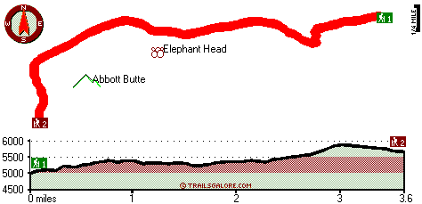
Trailhead 1 to Trailhead 2: Total hiking length = 3.6 miles Total climbing distance = 1.7 miles Difficulty : Medium Casual Hiking Pace:
3.5 hours
Fast Hiking Pace:
2 hours
Trailhead 2 to Trailhead 1: Total hiking length = 3.6 miles Total climbing distance = 1.3 miles Difficulty : Medium Casual Hiking Pace:
3 hours
Fast Hiking Pace:
1.5 hours
| | Trailhead 1 back to Trailhead 1: Total hiking length = 7.2 miles Total climbing distance = 3 miles Difficulty : Difficult Casual Hiking Pace:
6.5 hours
Fast Hiking Pace:
4 hours
Trailhead 2 back to Trailhead 2: Total hiking length = 7.2 miles Total climbing distance = 3 miles Difficulty : Difficult Casual Hiking Pace:
6.5 hours
Fast Hiking Pace:
4 hours
|
Total elevation difference: 1122 feet

Super 8 Motel Medford OR, Medford
|
37 miles away
75 Rooms Indoor Heated Pool with an 80 Foot Waterslide Indoor Spa Easy Access Off I-5 Within 1 Mile From The Jacksonville Medford International Airport Within 3 Miles to Rogue Valley Regiona...
|
| |
Courtyard by Marriott Medford Airport, Medford
|
38 miles away
Open in July 2005, the Medford Airport Courtyard is located minutes from downtown Medford and Central Point. Travelers can experience the beauty of Southern Oregon by rafting on the Rogue River or at...
|
|
User input for Umpqua Rogue Trail, Southern Cascade Range, Douglas County, Oregon:

Outdoors Recreation Near Medford, Oregon Very comprehensive list of a variety of outdoors recreation in the vicinity of Medford, Oregon, the metro area neareast to Umpqua Rogue Trail. Find info on campgrounds, hiking trails, ski resorts, lakes, beaches, parks, whitewater and more.
More Hotels and Campgrounds Near Umpqua Rogue Trail, Southern Cascade Range, Douglas County, Oregon
| |
| |
 |
|
| These outdoors activities are available near Umpqua Rogue Trail. |
| | Trails Near Umpqua Rogue Trail:
 |
Sandstone Trail, Douglas County
County
, 4 miles away, 3.9 hiking miles, 2406 feet elevation difference |
 |
Anderson Mountain Trail, Douglas County
County
, 5 miles away, 6.8 hiking miles, 1906 feet elevation difference |
 |
Flat Creek Trail, Jackson County
County
, 5 miles away, 2.5 hiking miles, 229 feet elevation difference |
 |
Jackson Creek Trail, Douglas County
County
, 6 miles away, 2.9 hiking miles, 1219 feet elevation difference |
 |
Fish Lake Trail, Douglas County
County
, 7 miles away, 9 hiking miles, 2685 feet elevation difference |
 |
Acker Divide Trail, Douglas County
County
, 7 miles away, 10.8 hiking miles, 1953 feet elevation difference |
|
| | Whitewater Near Umpqua Rogue Trail:
 |
Rogue River - North Fork, Jackson County
County
, 5 miles away, Class IV - 3 miles long (Natural Bridge to Woodruff Bridge) |
 |
Jackson Creek, Douglas County
County
, 7 miles away, Class IV(V) - 8 miles long (NF300 to Cover Camp) |
 |
Rogue River - North Fork, Jackson County
County
, 8 miles away, Class III - 6 miles long (River Bridge to North Fork Park) |
 |
Rogue River - North Fork, Jackson County
County
, 11 miles away, Class IV(V+) - 3.3 miles long (Mill Creek Falls to Lost Creek Lake) |
 |
Jackson Creek, Douglas County
County
, 15 miles away, Class III-IV - 8 miles long (Cover Camp to FS 31) |
|
| | Hotels Near Umpqua Rogue Trail:
 |
Super 8 Motel Medford OR, Medford
, 37 miles away |
 |
Courtyard by Marriott Medford Airport, Medford
, 38 miles away |
 |
Candlewood Suites MEDFORD, Medford
, 38 miles away |
 |
Comfort Inn North, Medford
, 38 miles away |
 |
Rogue Regency, Medford
, 38 miles away |
|
|
|
 |
|