Oregon hiking trails - Twin Peaks Trail, Central Cascade Range, Lane County

   
  Hey, time for a backcountry hike don’t you think? Twin Peaks Trail in Lane County, Oregon is the wilderness at its best. Tremendous great outdoors hiking trails in Oregon are in abundance, and among these are Twin Peaks Trail in Lane County. You'll have to go far from Bend to get to Twin Peaks Trail, but it is a brilliant wilderness trail. At Twin Peaks Trail throughout the summer months highs are in the 80's. Summer overnight lows sink down to the 40's. High temperatures during the winter are normally in the 40's while the cold winter nights at Twin
    Peaks Trail are in the 20's. Twin Peaks Trail is a quite wet place generally with a good deal of rainfall; of all the months in a year December is the one with the most rain, and the driest of the months is July. Twin Peaks Trail is 15.8 miles long; it's longer than many wilderness
trails. Twin Peaks Trail has two trailheads, so if you can get a ride from someone, you can backcountry hike it just one way. This is a vicinity covered with lots of wilderness hiking trails. If you happen to be in Oregon, why not go backpacking, it never gets boring. Of course, this is an overnight walk, 2.5 days normally, so make sure you've got all your overnight gear packed. Don’t forget to check for any current restrictions or closures before you go. These backpacking trails here in the Central Cascade Range are a really good way to spend quality  
time in the wilderness. This trail sometimes gets very dry, so do check for current fire restrictions before you go if you plan to bring a stove or make a camp fire. In Oregon you never run out of outdoors fun. Keep in mind that this is a long trail, so make sure you bring plenty of supplies. You spend the whole backcountry hike in roughly the same elevation zone, so you won’t have to worry about different climate zones along your backcountry hike. This backpacking trail is a backpacking trail of good length with an average amount of climbing distance which makes this wilderness hiking trail nice for hard core backpackers looking for adventure. There are numerous great outdoors hiking trails in Oregon, and each one is well worth a backcountry walk. The total elevation difference for Twin Peaks Trail is 1,368 feet which is an average number.

Briefly about the general area:
You just can't envision the amount of outdoors entertaining things the Central Cascade Range has to offer. Looking for some flowing water? Try Ray Creek, and camping at Shelter Cove Resort is always a perfect experience. Skyline Creek is a great local stream; if you're here, do take a journey to Islet Point.
Clover Meadow is a great spot to stretch your legs a bit, and Lillian Falls is an inspiring place to check out while here. If you adore the outdoors, you'll fancy Twin Peaks Trail. A pleasant spot to camp here at Twin Peaks Trail is North Wickiup Campground, and a short visit to Benz Spring is always worthwhile. Having a fine time in the Central Cascade Range is trouble-free. A pleasant trip to Long Meadow is a great way to spend an afternoon.
Since you're here at Twin Peaks Trail why not visit Maiden Peak Saddle, and whitewater paddling is perfect on McKenzie River - South Fork.

Location of Trailhead 1: Latitude 43.6783, Longitude -122.0177
- - Directions and Road Map

Location of Trailhead 2: Latitude 43.7494, Longitude -121.9712
- - Directions and Road Map


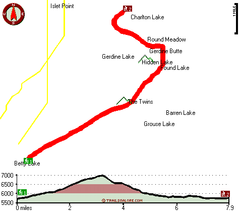
Trailhead 1 to Trailhead 2:
Total hiking length = 7.9 miles
Total climbing distance = 3.8 miles
Difficulty : Difficult
Casual Hiking Pace: 7.5 hours
Fast Hiking Pace: 4 hours

Trailhead 2 to Trailhead 1:
Total hiking length = 7.9 miles
Total climbing distance = 2.9 miles
Difficulty : Difficult
Casual Hiking Pace: 6.5 hours
Fast Hiking Pace: 3.5 hours
    Trailhead 1 back to Trailhead 1:
Total hiking length = 15.8 miles
Total climbing distance = 6.7 miles
Difficulty : Difficult
Casual Hiking Pace: 2.5 days
Fast Hiking Pace: 9 hours

Trailhead 2 back to Trailhead 2:
Total hiking length = 15.8 miles
Total climbing distance = 6.7 miles
Difficulty : Difficult
Casual Hiking Pace: 2.5 days
Fast Hiking Pace: 9 hours

Total elevation difference: 1368 feet


Best Western Newberry Station, La Pine
33 miles away
Stay at this La Pine, Oregon hotel, a central location to five of the major recreational areas in Oregon including Crater Lake and the 14 lake Cascade Lakes. Welcome to the Best Western Newberry Sta...
  
Best Western Oakridge Inn, Oakridge
35 miles away
This Oakridge, Oregon hotel offers a complimentary continental breakfast each morning and convenient access to a variety of outdoor activities. Discover the Best Western Oakridge Inn, nestled agains...
User input for Twin Peaks Trail, Central Cascade Range, Lane County, Oregon:

Submit Input:
Your Name:
Write or Paste Input here:

Upload picture:      Review Guidelines


Outdoors Recreation Near Bend, Oregon
Very comprehensive list of a variety of outdoors recreation in the vicinity of Bend, Oregon, the metro area neareast to Twin Peaks Trail. Find info on campgrounds, hiking trails, ski resorts, lakes, beaches, parks, whitewater and more.

Current weather conditions at Twin Peaks Trail, Central Cascade Range, Lane County, Oregon
WXPort

Local climate location: MC KENZIE BRIDGE R S 20 miles away

Sunriver Resort, Sunriver
38 miles away
Sunriver Resort is located at the foot of the Cascade Mountain range in Central Oregon- 15 miles south of Bend. A four-star- full-service resort for family- couples and business. Offering world-class ...

The Pines at Sunriver, Sunriver
39 miles away
Located 35 miles from Redmond Airport and 175 miles from Portland Airport. Sunriver offers overnight accommodations after a strenuous day on Mount Bachelor which boasts coast from Canada to Californi...

More Hotels and Campgrounds Near Twin Peaks Trail, Central Cascade Range, Lane County, Oregon

OTHER_INFO
  Central Cascade Range Campgrounds
Complete list of all the campgrounds in the Central Cascade Range.

Central Cascade Range Outdoors Info
Complete outdoors info for the Central Cascade Range.

Oregon Hiking Trails
Complete list of all hiking trails in Oregon

Books about hiking trails in Oregon
List of books available on Amazon.com about hiking trails in Oregon.

Oregon Outdoors Index
This is a very comprehensive index of outdoors activities in the great state of Oregon.


TOPO
High quality water resistant topo map of Twin Peaks Trail, Central Cascade Range, Lane County, Oregon.

OUTDOORS_GUIDE
These outdoors activities are available near Twin Peaks Trail.
 Trails Near Twin Peaks Trail:
Crain Prairie Trail, Lane County County , 4 miles away, 18.3 hiking miles, 504 feet elevation difference
Moore Creek Trail, Deschutes County County , 4 miles away, 10.1 hiking miles, 1397 feet elevation difference
Maiden Peak Trail, Lane County County , 4 miles away,  10.4 hiking miles, 3274 feet elevation difference
Mount Ray Trail, Lane County County , 6 miles away,  4.6 hiking miles, 1058 feet elevation difference
Gold Lake Trail, Lane County County , 7 miles away, 2.1 hiking miles, 493 feet elevation difference
Island Lake Trail, Lane County County , 7 miles away,  8.2 hiking miles, 1361 feet elevation difference
Waldo Lake Trail, Lane County County , 7 miles away,  10.6 hiking miles, 2265 feet elevation difference
 Camp Grounds Near Twin Peaks Trail:
Shelter Cove Resort, Crescent Lake, 10 miles away
North Wickiup Campground, Deschutes County, 16 miles away
Twin Springs Campground, Lane County, 16 miles away
East Lake Resort and RV Parks, La Pine, 17 miles away
Upper Campground, Deschutes County, 18 miles away
 Whitewater Near Twin Peaks Trail:
McKenzie River - South Fork, Lane County County , 21 miles away, Class III-IV - 6.2 miles long (Dutch Oven Camp to Cougar Reservoir)
Horse Creek, Lane County County , 23 miles away, Class III - 11 miles long (above Separation Creek to McKenzie River)
Deschutes River, Deschutes County County , 23 miles away, Class I-IV - 9 miles long (Wickiup Dam to Pringle Falls)
Hills Creek, Lane County County , 25 miles away, Class IV - 6 miles long (6 mi above Reservoir)
Salt Creek, Lane County County , 26 miles away, Class III-IV - 7.2 miles long (McCredie Hot Springs to Rigdon Road Bridge)
 National Parks Near Twin Peaks Trail:
Crater Lake National Park, Crater Lake - OR , 42 miles away
 Hotels Near Twin Peaks Trail:
Best Western Newberry Station, La Pine , 33 miles away
Best Western Oakridge Inn, Oakridge , 35 miles away
Sunriver Resort, Sunriver , 38 miles away
The Pines at Sunriver, Sunriver , 39 miles away
Lodge at Suttle Lake, Sisters , 40 miles away
 Lakes Near Twin Peaks Trail
Torrey Lake, Lane County , 5 miles away

Outdoors related information copyright © Stratus-Pikpuk, Inc. - Detailed hotel information copyright © Interactive Hotel Solutions