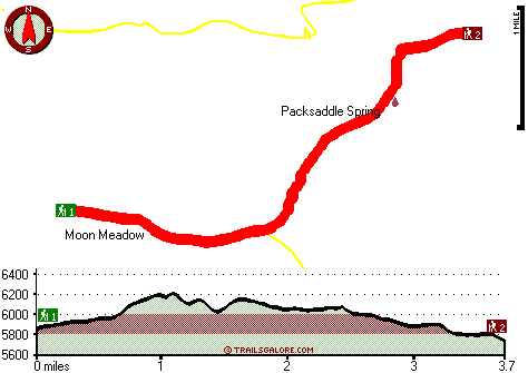
Oregon hiking trails - Trout Meadows Trail, Blue Mountains, Grant County

   
  Can’t wait to get out in the outdoors, Trout Meadows Trail in Grant County, Oregon is a brilliant site for getting out. There are so many delightful wilderness trails for hiking in Oregon; among these are Trout Meadows Trail in Grant County. Here in Oregon hiking is so much fun. Please follow all local rules about fires and camping. At parts of the year this vicinity sees very little rain, so don’t forget to check for any current fire restrictions before you go. Summertime highs at Trout Meadows Trail usually tend to be in the 80's, and throughout the
    night it cools down to the 30's. Highs throughout the wintertime are typically in the 30's, and overnight lows throughout the wintertime for Trout Meadows Trail tend to be in the 10's. Backcountry backpacking in Oregon is such a tremendous thing to do. You should count on this
backcountry trek taking about 6.5 hours, but of course some people walk a bit slower and some a bit faster. At Trout Meadows Trail you don’t see much rain; November is the month that gets the most rain; July meanwhile is the driest month. The total elevation difference for this backcountry trail is 508 feet which is lower than average. Trout Meadows Trail is a mid-length wilderness trail with an average amount of climbing distance which makes this hiking trail brilliant for hard core backpackers looking for adventure. Every single Oregon wilderness trail  
is well worth a backcountry trek. The hiking trail stays roughly within the same elevation zone the whole time, so you won’t have to worry about different climate zones along your hike. Trout Meadows Trail is not very in the neighborhood of La Grande at all, but it is an enjoyable site to backcountry hike. Being 7.4 miles long it's an average length hiking trail. The wilderness trails of the Blue Mountains are a really great way to spend quality time in the wilderness. Now this backpacking trail is pretty long, so make sure you bring plenty of supplies. There are so many hiking trails in this neighborhood. This is a two-ended backcountry trail with two trailheads, so backpacking it one way is an option if you can arrange for a ride back.

Briefly about the general area:
Camping is available at Corrigal Spring Campground, and you could always explore McCarty Gulch. These mountains rock, just check out all the enjoyable stuff to do in the Blue Mountains. Take a side trip to Squaw Creek; China Meadow is a wonderful place to check out.
Packsaddle Spring is an inspiring place to go to while you're here, and spots like Moon Meadow are wonderful to have a look at. If you came for an overnight stay Time and a Half Campground is a splendid spot to camp, and paddling on John Day River - North Fork is so much fun. Trout Meadows Trail beyond doubt is in the middle of a lovely outdoors paradise. Badger Creek is a beautiful stream that is worth a visit.

Location of Trailhead 1: Latitude 44.9351, Longitude -118.5474
- - Directions and Road Map

Location of Trailhead 2: Latitude 44.9558, Longitude -118.4997
- - Directions and Road Map


Trailhead 1 to Trailhead 2:
Total hiking length = 3.7 miles
Total climbing distance = 1.7 miles
Difficulty : Medium
Casual Hiking Pace: 3.5 hours
Fast Hiking Pace: 2 hours

Trailhead 2 to Trailhead 1:
Total hiking length = 3.7 miles
Total climbing distance = 1.7 miles
Difficulty : Medium
Casual Hiking Pace: 3.5 hours
Fast Hiking Pace: 2 hours
    Trailhead 1 back to Trailhead 1:
Total hiking length = 7.4 miles
Total climbing distance = 3.4 miles
Difficulty : Difficult
Casual Hiking Pace: 6.5 hours
Fast Hiking Pace: 4.5 hours

Trailhead 2 back to Trailhead 2:
Total hiking length = 7.4 miles
Total climbing distance = 3.4 miles
Difficulty : Difficult
Casual Hiking Pace: 6.5 hours
Fast Hiking Pace: 4.5 hours

Total elevation difference: 508 feet


Rugged Country Lodge DBA Double H Investments, Pendleton
36 miles away
Rugged Country Lodge- Pendleton's only 'bed-and-breakfast motel.' Completely renovated. All non-smoking. Affordable rates. Luxury queen beds. Down bedding. Fridges and microwaves. Air-conditioning. Fr...
  
La Grande Travelodge, La Grande
36 miles away
Free Wireless Internet Located in the Heart of La Grande Guests receive 10 percent off at 5 nearby restaurants Free Continental Breakfast Cookies in the afternoon Refrigerator, Coffee Pots, Microwave...
User input for Trout Meadows Trail, Blue Mountains, Grant County, Oregon:

Submit Input:
Your Name:
Write or Paste Input here:

Upload picture:      Review Guidelines


Outdoors Recreation Near La Grande, Oregon
Very comprehensive list of a variety of outdoors recreation in the vicinity of La Grande, Oregon, the metro area neareast to Trout Meadows Trail. Find info on campgrounds, hiking trails, ski resorts, lakes, beaches, parks, whitewater and more.

Current weather conditions at Trout Meadows Trail, Blue Mountains, Grant County, Oregon
WXPort

Local climate location: UKIAH 7 miles away

Lagrande Super 8 Motel, La Grande
36 miles away
Welcome to the Super 8 LaGrange. Our property is AAA Approved, we offer our guests a SuperStart breakfast, indoor heated pool and hot tub, high speed internet, cable TV w/HBO, ESPN, in-room coffee ma...

Best Western Rama Inn & Suites, La Grande
36 miles away
Discover this La Grande hotel surrounded by the natural beauty of Eastern Oregon conveniently located near Eastern Oregon University and Boise Cascade. Nestled between the beautiful Blue Mountains i...

More Hotels and Campgrounds Near Trout Meadows Trail, Blue Mountains, Grant County, Oregon

OTHER_INFO
  Blue Mountains Campgrounds
Complete list of all the campgrounds in the Blue Mountains.

Blue Mountains Outdoors Info
Complete outdoors info for the Blue Mountains.

Oregon Hiking Trails
Complete list of all hiking trails in Oregon

Books about hiking trails in Oregon
List of books available on Amazon.com about hiking trails in Oregon.

Oregon Outdoors Index
This is a very comprehensive index of outdoors activities in the great state of Oregon.


TOPO
High quality water resistant topo map of Trout Meadows Trail, Blue Mountains, Grant County, Oregon.

OUTDOORS_GUIDE
These outdoors activities are available near Trout Meadows Trail.
 Trails Near Trout Meadows Trail:
Martin Creek Trail, Grant County County , 1 miles away, 4.4 hiking miles, 902 feet elevation difference
Wagner Gulch Trail, Grant County County , 2 miles away, 5.6 hiking miles, 2158 feet elevation difference
Blackwell Trail, Grant County County , 2 miles away,  7.6 hiking miles, 2286 feet elevation difference
Indian Trail, Grant County County , 3 miles away, 6.7 hiking miles, 1314 feet elevation difference
Silver Butte Trail, Grant County County , 4 miles away, 7.8 hiking miles, 2246 feet elevation difference
Paradise Trail, Grant County County , 4 miles away,  8.6 hiking miles, 2883 feet elevation difference
Fly Creek Trail, Umatilla County County , 5 miles away, 6.5 hiking miles, 1916 feet elevation difference
 Camp Grounds Near Trout Meadows Trail:
Corrigal Spring Campground, Grant County, 14 miles away
Time and a Half Campground, Union County, 15 miles away
Camp Elkanah Campground, La Grande, 15 miles away
Deerhorn Campground, Grant County, 16 miles away
 Whitewater Near Trout Meadows Trail:
John Day River - North Fork, Grant/ Umatilla County County , 10 miles away, Class II-III - 41 miles long (Route 52 Bridge to Dale)
 Hotels Near Trout Meadows Trail:
Rugged Country Lodge DBA Double H Investments, Pendleton , 36 miles away
La Grande Travelodge, La Grande , 36 miles away
Lagrande Super 8 Motel, La Grande , 36 miles away
Best Western Rama Inn & Suites, La Grande , 36 miles away
Pendleton Super 8 Motel, Pendleton , 39 miles away

Outdoors related information copyright © Stratus-Pikpuk, Inc. - Detailed hotel information copyright © Interactive Hotel Solutions