Oregon hiking trails - Tom and Jerry Trail, Southern Cascade Range, Klamath County

   
  There are so many wonderful backpacking trails for hiking in Oregon; one of them being Tom and Jerry Trail in Klamath County. No chance of getting bored in Oregon if you like the outdoors. Can’t wait to get out in nature, Tom and Jerry Trail in Klamath County, Oregon is such a tremendous place. Every Oregon backpacking trail is worth hiking. An average amount of rain falls at Tom and Jerry Trail; during the month of November you get the most rain around here while July is generally the driest month. Different parts of Tom and Jerry Trail are at very
    different elevations, and that means that some parts of the wilderness hiking trail could be very different from other parts of it. Tom and Jerry Trail is a backcountry trail quite far from Klamath Falls, but It's always exciting to backcountry walk here. This great outdoors hiking
trail sometimes gets very dry, so make sure you check current conditions and fire restrictions with local forest authorities before you head out. Backcountry hiking here in the Southern Cascade Range is a perfect way to explore these highlands. Going for a backcountry walk here in Oregon is a nice way to spend some time. Tom and Jerry Trail is quite long, so make sure you bring plenty of supplies. Summer brings highs in the 80's to Tom and Jerry Trail, and during the night it cools down to the 40's. The winter comes with highs in the 40's, and during  
the dark hours in the winter at Tom and Jerry Trail temperatures fall to the 20's. And keep in mind that there could be temporary safety restrictions in place. This backcountry hike shouldn't take more than 9 hours, but you never know stuff could go wrong and you could get stuck so be prepared for that. This is a one trailhead backpacking trail, so you're looking at an in and out backcountry trek. This backpacking trail has a total elevation difference of 1,530 feet, and that is about average. Tom and Jerry Trail is many miles long with an average amount of climbing distance which makes this hiking trail good for hard core backpackers looking for adventure. This is just one of a large number of hiking trails in this region. Being 10 miles long; it's considered a longer trek.

Briefly about the general area:
Whitewater paddling is nice on Rogue River - North Fork, and Varmint Creek is one of the streams nearby that might be worth a visit. All the outdoors cool stuff in the Southern Cascade Range will keep you coming back over and over. Since you're here at Tom and Jerry Trail why not visit Snowbrush Gulch.
Not enough hours in a day to enjoy the Southern Cascade Range. Camping at Tom and Jerry Trail is great fun, Sevenmile Marsh Campground is a great local campground; a pleasant trip to Lucky Meadows is a great way to spend an afternoon. So many cool things in the vicinity of Tom and Jerry Trail, completely fantastic. If you came for an overnight stay Hemlock Lake Campground is a pleasant place to camp, and Spring Prairie is a beautiful place any time of year. Put some time aside to spend at Otter Spring while you're here at Tom and Jerry Trail, and let's not forget Halifax Creek which is a stream that you may encounter during your stay.
This river is so wonderful. Crippled Horse Spring is always fun to check out; if you're looking for a nice spree, Crater Lake National Park is reasonably near.

Location of Trailhead: Latitude 42.7575, Longitude -122.295
- - Directions and Road Map

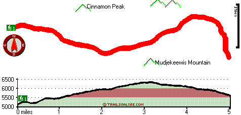
Total in and out hiking length = 10 miles

Total climbing distance = 4.2 miles

Difficulty : Difficult

Casual Hiking Pace: 9 hours

Fast Hiking Pace: 5.5 hours

Total elevation difference: 1530 feet


Spring Creek Ranch, Chiloquin
27 miles away
  
Lithia Springs Resort And Gardens, Ashland
36 miles away
Hello, from Ashland, Oregon! Imagine, at the end of a long day's travel, relaxing in a 2 person whirlpool filled with hot mineral water, right in your own room. Lay back, Let the relaxing quality of t...
User input for Tom and Jerry Trail, Southern Cascade Range, Klamath County, Oregon:

Submit Input:
Your Name:
Write or Paste Input here:

Upload picture:      Review Guidelines


Outdoors Recreation Near Klamath Falls, Oregon
Very comprehensive list of a variety of outdoors recreation in the vicinity of Klamath Falls, Oregon, the metro area neareast to Tom and Jerry Trail. Find info on campgrounds, hiking trails, ski resorts, lakes, beaches, parks, whitewater and more.

Current weather conditions at Tom and Jerry Trail, Southern Cascade Range, Klamath County, Oregon
WXPort

Local climate location: PROSPECT 16 miles away

Windmill Inn And Suites Of Ashland, Ashland
40 miles away
Discover one of the Northwests most luxurious inns. Escape civilizations cares without leaving its pleasures behind. Come and enjoy the quiet side of Ashland. All suite hotel with magnificent panora...

Holiday Inn Express Hotel & Suites Ashland, Or, Ashland
40 miles away
The Holiday Inn Express Hotel & Suites in Ashland is the gateway to your Oregon adventure. Our hotel features a warm, elegant environment. Conveniently placed near all of Ashland's attractions, you wi...

More Hotels and Campgrounds Near Tom and Jerry Trail, Southern Cascade Range, Klamath County, Oregon

OTHER_INFO
  Southern Cascade Range Campgrounds
Complete list of all the campgrounds in the Southern Cascade Range.

Southern Cascade Range Outdoors Info
Complete outdoors info for the Southern Cascade Range.

Oregon Hiking Trails
Complete list of all hiking trails in Oregon

Books about hiking trails in Oregon
List of books available on Amazon.com about hiking trails in Oregon.

Oregon Outdoors Index
This is a very comprehensive index of outdoors activities in the great state of Oregon.


TOPO
High quality water resistant topo map of Tom and Jerry Trail, Southern Cascade Range, Klamath County, Oregon.

OUTDOORS_GUIDE
These outdoors activities are available near Tom and Jerry Trail.
 Trails Near Tom and Jerry Trail:
Red Blanket Trail, Jackson County County , 3 miles away, 2.6 hiking miles, 2031 feet elevation difference
Alta Lake Trail, Klamath County County , 4 miles away,  13.8 hiking miles, 3119 feet elevation difference
Bessie Rock Trail, Jackson County County , 4 miles away,  1.6 hiking miles, 1635 feet elevation difference
King Spruce Trail, Klamath County County , 5 miles away,  5.6 hiking miles, 974 feet elevation difference
Cold Spring Trail, Jackson County County , 5 miles away,  4.8 hiking miles, 363 feet elevation difference
Moude Mountain Trail, Klamath County County , 5 miles away,  29 hiking miles, 1315 feet elevation difference
Seven Lakes Trail, Jackson County County , 5 miles away,  8.4 hiking miles, 2741 feet elevation difference
 Camp Grounds Near Tom and Jerry Trail:
Hemlock Lake Campground, Klamath County, 7 miles away
Sevenmile Marsh Campground, Klamath County, 8 miles away
Mazama Campground, Klamath County, 9 miles away
Upper South Fork Campground, Jackson County, 9 miles away
Saddle Campground, Jackson County, 12 miles away
 Whitewater Near Tom and Jerry Trail:
Rogue River - North Fork, Jackson County County , 16 miles away, Class III - 6 miles long (River Bridge to North Fork Park)
Rogue River - North Fork, Jackson County County , 17 miles away, Class IV - 3 miles long (Natural Bridge to Woodruff Bridge)
Rogue River - North Fork, Jackson County County , 18 miles away, Class IV(V+) - 3.3 miles long (Mill Creek Falls to Lost Creek Lake)
 National Parks Near Tom and Jerry Trail:
Crater Lake National Park, Crater Lake - OR , 12 miles away
Lava Beds National Monument, Tulelake - CA , 68 miles away
 Hotels Near Tom and Jerry Trail:
Mazama Village Motor Inn, Crater Lake , 11 miles away
Union Creek Resort, Prospect , 15 miles away
Prospect Historical Hotel, Prospect , 16 miles away
Aspen Inn Motel, Fort Klamath , 18 miles away
Ft. Klamath Lodge & Rv, Fort Klamath , 18 miles away
 Lakes Near Tom and Jerry Trail
Lake Ivern, Klamath County , 5 miles away

Outdoors related information copyright © Stratus-Pikpuk, Inc. - Detailed hotel information copyright © Interactive Hotel Solutions