| |
There are two trailheads to chose from, one in each end which means you have the option of backcountry hiking it one way if you have someone to pick you up at the other end. This hiking and backpacking trail has a total elevation difference of 2,444 feet which is about average. This is a wilderness trail that is quite long, so make sure you bring plenty of supplies. You should count on this walk taking about 6.5 hours, but you never know stuff could go wrong and you could get stuck so be prepared for that. Being 7.6 miles long it's an average length hiking and backpacking trail. Tison Trail goes through some very different elevations, so keep in mind that you may need to dress differently at different elevations. This wilderness trail sometimes gets very dry, so don’t forget to check for any current fire restrictions before you go.
|
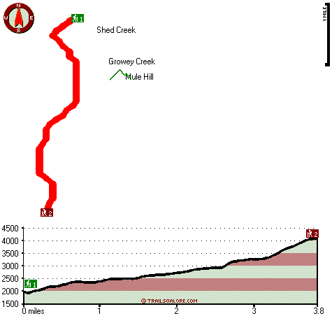
Trailhead 1 to Trailhead 2:
Total hiking length = 3.8 miles
Total climbing distance = 2.8 miles
Difficulty : Difficult
Casual Hiking Pace:
4 hours
Fast Hiking Pace:
2.5 hours
Trailhead 2 to Trailhead 1:
Total hiking length = 3.8 miles
Total climbing distance = .2 miles
Difficulty : Easy
Casual Hiking Pace:
2.5 hours
Fast Hiking Pace:
1.5 hours
| | Trailhead 1 back to Trailhead 1:
Total hiking length = 7.6 miles
Total climbing distance = 3 miles
Difficulty : Difficult
Casual Hiking Pace:
6.5 hours
Fast Hiking Pace:
4 hours
Trailhead 2 back to Trailhead 2:
Total hiking length = 7.6 miles
Total climbing distance = 3 miles
Difficulty : Difficult
Casual Hiking Pace:
6.5 hours
Fast Hiking Pace:
4 hours
|
Total elevation difference: 2444 feet
|


